National Register of Historic Places listings in Yazoo County, Mississippi
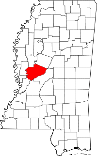
Location of Yazoo County in Mississippi
This is a list of the National Register of Historic Places listings in Yazoo County, Mississippi.
This is intended to be a complete list of the properties and districts on the National Register of Historic Places in Yazoo County, Mississippi, United States. Latitude and longitude coordinates are provided for many National Register properties and districts; these locations may be seen together in a map.[1]
There are 14 properties and districts listed on the National Register in the county, including 1 National Historic Landmark.
- This National Park Service list is complete through NPS recent listings posted October 11, 2018.[2]
Current listings
| [3] | Name on the Register[4] | Image | Date listed[5] | Location | City or town | Description |
|---|---|---|---|---|---|---|
| 1 | Afro-American Sons and Daughters Hospital | January 24, 2006 (#05001558) |
8th St. and Webster Ave. 32°51′22″N 90°24′03″W / 32.856111°N 90.400833°W |
Yazoo City | ||
| 2 | Bull Homestead | January 17, 2002 (#01001479) |
13836 Mississippi Highway 16, E. 32°45′58″N 90°10′23″W / 32.766111°N 90.173056°W |
Benton | ||
| 3 | Casey Jones Wreck Site | April 3, 1973 (#73001033) |
1 mile north of Vaughan 32°49′00″N 90°02′07″W / 32.816667°N 90.035278°W |
Vaughan | ||
| 4 | Deasonville Archeological Site | April 29, 1993 (#93000299) |
Address Restricted |
Deasonville | ||
| 5 | Fairview Landing (22Yz561) | December 14, 1988 (#88002699) |
Address Restricted |
Holly Bluff | ||
| 6 | Big John Hart House | July 1, 1993 (#93000580) |
Castle Chapel Rd., southeast of Yazoo City 32°45′20″N 90°22′06″W / 32.755556°N 90.368333°W |
Yazoo City | ||
| 7 | Holly Bluff Site |  |
October 15, 1966 (#66000412) |
Address Restricted |
Holly Bluff | |
| 8 | Home Place | September 26, 1988 (#88001584) |
2 miles east of Mississippi Highway 433, southern side of Midway to Ebeneezer Rd. 32°53′02″N 90°09′40″W / 32.883889°N 90.161111°W |
Benton | ||
| 9 | Mosely-Woods House | June 25, 2005 (#05000623) |
1461 Bell Rd. 32°49′20″N 90°26′07″W / 32.822222°N 90.435278°W |
Yazoo City | ||
| 10 | Augustus J. Oakes House | .jpg) |
April 8, 1993 (#93000207) |
308 Monroe St. 32°50′37″N 90°24′50″W / 32.843611°N 90.413889°W |
Yazoo City | |
| 11 | Ricks Memorial Library | 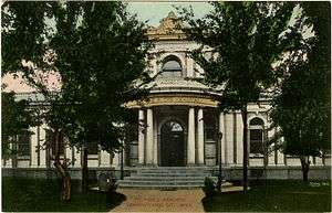 |
September 18, 1975 (#75001062) |
310 N. Main St. 32°50′55″N 90°24′43″W / 32.848611°N 90.411944°W |
Yazoo City | |
| 12 | Rosedale Plantation | July 20, 2011 (#11000474) |
5302 Bend Rd. 32°47′43″N 90°04′03″W / 32.795278°N 90.0675°W |
Vaughn vicinity | ||
| 13 | Shellwood Site (22YZ600) | April 25, 1986 (#86000869) |
Address Restricted |
Lake City | ||
| 14 | Yazoo City Town Center Historic District | April 16, 1979 (#79001342) |
Irregular pattern along Main, Madison, and Broadway Sts. 32°50′46″N 90°24′39″W / 32.846111°N 90.410833°W |
Yazoo City |
See also
| Wikimedia Commons has media related to National Register of Historic Places in Yazoo County, Mississippi. |
References
- ↑ The latitude and longitude information provided in this table was derived originally from the National Register Information System, which has been found to be fairly accurate for about 99% of listings. For about 1% of NRIS original coordinates, experience has shown that one or both coordinates are typos or otherwise extremely far off; some corrections may have been made. A more subtle problem causes many locations to be off by up to 150 yards, depending on location in the country: most NRIS coordinates were derived from tracing out latitude and longitudes from USGS topographical quadrant maps created under the North American Datum of 1927, which differs from the current, highly accurate WGS84 GPS system used by most on-line maps. Chicago is about right, but NRIS longitudes in Washington are higher by about 4.5 seconds, and are lower by about 2.0 seconds in Maine. Latitudes differ by about 1.0 second in Florida. Some locations in this table may have been corrected to current GPS standards.
- ↑ "National Register of Historic Places: Weekly List Actions". National Park Service, United States Department of the Interior. Retrieved on October 11, 2018.
- ↑ Numbers represent an ordering by significant words. Various colorings, defined here, differentiate National Historic Landmarks and historic districts from other NRHP buildings, structures, sites or objects.
- ↑ National Park Service (2009-03-13). "National Register Information System". National Register of Historic Places. National Park Service.
- ↑ The eight-digit number below each date is the number assigned to each location in the National Register Information System database, which can be viewed by clicking the number.
| Topics | |
|---|---|
| Lists by states |
|
| Lists by insular areas | |
| Lists by associated states | |
| Other areas | |
| |
Municipalities and communities of Yazoo County, Mississippi, United States | ||
|---|---|---|
| Cities | | |
| Towns | ||
| Villages | ||
| Unincorporated communities | ||
| Ghost towns | ||
This article is issued from
Wikipedia.
The text is licensed under Creative Commons - Attribution - Sharealike.
Additional terms may apply for the media files.