Hopewell Landing, Mississippi
| Hopewell Landing, Mississippi | |
|---|---|
| Unincorporated community | |
 Hopewell Landing, Mississippi  Hopewell Landing, Mississippi | |
| Coordinates: 32°40′54″N 90°36′30″W / 32.68167°N 90.60833°WCoordinates: 32°40′54″N 90°36′30″W / 32.68167°N 90.60833°W | |
| Country | United States |
| State | Mississippi |
| County | Washington |
| Elevation | 85 ft (26 m) |
| Time zone | UTC-6 (Central (CST)) |
| • Summer (DST) | UTC-5 (CDT) |
| Area code(s) | 662 |
| GNIS feature ID | 692252[1] |
Hopewell Landing is an unincorporated community in Yazoo County, Mississippi. It lies at an elevation of 85 feet (26 m).
Located on the Yazoo River, it was noted in the 1870s and 1880s as a steamboat landing.[1][2]
Residents are within the Yazoo County School District. Residents are zoned to Yazoo County Middle School and Yazoo County High School.
References
- 1 2 U.S. Geological Survey Geographic Names Information System: Hopewell Landing, Mississippi
- ↑ Cayton, Frank M. (1881). "Landings on All the Western and Southern Rivers and Bayous: Showing Location, Post Offices, &c". Woodward, Tiernan & Hale.
Municipalities and communities of Yazoo County, Mississippi, United States | ||
|---|---|---|
| Cities | 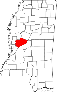 | |
| Towns | ||
| Villages | ||
| Unincorporated communities | ||
| Ghost towns | ||
This article is issued from
Wikipedia.
The text is licensed under Creative Commons - Attribution - Sharealike.
Additional terms may apply for the media files.