| [2] |
Name on the Register[3] |
Image |
Date listed[4] |
Location |
City or town |
Description |
|---|
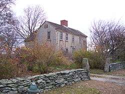
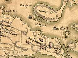
| 1 |
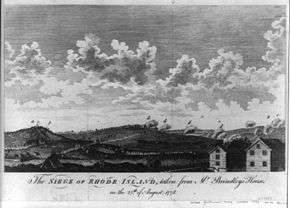
Battle of Rhode Island Site |
|
May 30, 1974
(#74002054) |
Lehigh Hill and both sides of RI 24 between Medley and Dexter Sts.
41°36′12″N 71°15′31″W / 41.603333°N 71.258611°W / 41.603333; -71.258611 (Battle of Rhode Island Site) |
Portsmouth |
Successful defense against British in 1778. Only Revolutionary War battle in which a segregated African-American unit fought (support logistics, 2 killed). |
| 2 |
Borden Farm |
|
June 5, 2007
(#07000528) |
2951 and 2967 E. Main Rd.
41°36′32″N 71°14′45″W / 41.608889°N 71.245833°W / 41.608889; -71.245833 (Borden Farm) |
Portsmouth |
|
| 3 |
Farnham Farm |
|
February 2, 2006
(#05001617) |
113 Mount Pleasant Ave.
41°35′52″N 71°19′22″W / 41.5979°N 71.3229°W / 41.5979; -71.3229 (Farnham Farm) |
Portsmouth |
|
| 4 |
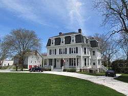
Greenvale Farm |
|
January 4, 1980
(#80000082) |
582 Wapping Rd.
41°32′05″N 71°14′18″W / 41.534722°N 71.238333°W / 41.534722; -71.238333 (Greenvale Farm) |
Portsmouth |
19th century estate house on the water below Greenvale Vineyard. |
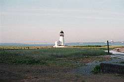
| 5 |
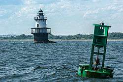
Hog Island Shoal Lighthouse |
|
March 30, 1988
(#88000282) |
S of Hog Island, E passage, Narrangansett Bay
41°37′56″N 71°16′25″W / 41.632222°N 71.273611°W / 41.632222; -71.273611 (Hog Island Shoal Lighthouse) |
Portsmouth |
|
| 6 |
Lawton-Almy-Hall Farm |
|
October 11, 1978
(#78000068) |
559 Union St.
41°33′35″N 71°16′31″W / 41.559722°N 71.275278°W / 41.559722; -71.275278 (Lawton-Almy-Hall Farm) |
Portsmouth |
|
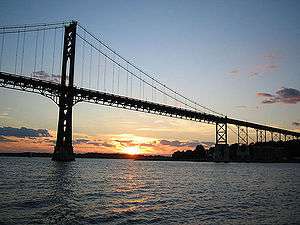
| 7 |
Mount Hope Bridge |
|
January 31, 1976
(#76000038) |
RI 114 over Narragansett Bay
41°38′25″N 71°15′32″W / 41.640278°N 71.258889°W / 41.640278; -71.258889 (Mount Hope Bridge) |
Portsmouth |
Longest bridge in New England for over 40 years |
| 8 |
Oak Glen |
|
March 29, 1978
(#78003444) |
745 Union St.
41°33′33″N 71°16′53″W / 41.559167°N 71.281389°W / 41.559167; -71.281389 (Oak Glen) |
Portsmouth |
|
| 9 |
Pine Hill Archeological Site, RI-655 |
|
November 3, 1983
(#83003803) |
Address Restricted
|
Portsmouth |
|
| 10 |
Portsmouth Friends Meetinghouse Parsonage and Cemetery |
|
March 7, 1973
(#73000053) |
11 Middle Rd. and 2232 E. Main Rd.
41°35′27″N 71°15′14″W / 41.590722°N 71.253822°W / 41.590722; -71.253822 (Portsmouth Friends Meetinghouse Parsonage and Cemetery) |
Portsmouth |
|
| 11 |
Prudence Island Lighthouse |
|
March 30, 1988
(#88000270) |
Eastern end of Sandy Pt. on Prudence Island
41°36′20″N 71°18′11″W / 41.605556°N 71.303056°W / 41.605556; -71.303056 (Prudence Island Lighthouse) |
Portsmouth |
part of the Lighthouses of Rhode Island TR |
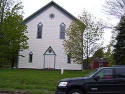
| 12 |
Union Church |
|
June 13, 1974
(#74000045) |
Union St. and E. Main Rd.
41°33′30″N 71°15′22″W / 41.558333°N 71.256111°W / 41.558333; -71.256111 (Union Church) |
Portsmouth |
|
| 13 |
Wreck Sites of H.M.S. Cerberus and H.M.S. Lark |
|
April 26, 1973
(#73000061) |
Waters of Narragansett Bay adjacent to Aquidneck Island
41°35′04″N 71°18′19″W / 41.584444°N 71.305278°W / 41.584444; -71.305278 (Wreck Sites of H.M.S. Cerberus and H.M.S. Lark) |
South Portsmouth |
|
_(extra_close)_(US48).svg.png)