| [2] |
Name on the Register[3] |
Image |
Date listed[4] |
Location |
City or town |
Description |
|---|
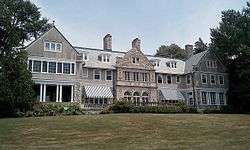
| 1 |
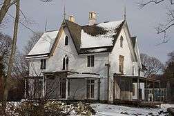
Blithewold |
|
June 27, 1980
(#80000074) |
Ferry Rd.
41°39′14″N 71°16′07″W / 41.653889°N 71.268611°W / 41.653889; -71.268611 (Blithewold) |
Bristol |
1890s summer retreat established by Augustus Van Wickle, Pennsylvania coal magnate |
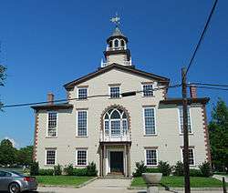
| 2 |
Bristol County Courthouse |
|
April 28, 1970
(#70000011) |
High St.
41°39′48″N 71°16′17″W / 41.663333°N 71.271389°W / 41.663333; -71.271389 (Bristol County Courthouse) |
Bristol |
|
| 3 |
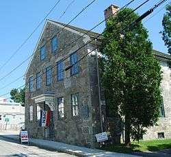
Bristol County Jail |
|
April 24, 1973
(#73000048) |
48 Court St.
41°40′10″N 71°16′32″W / 41.669444°N 71.275556°W / 41.669444; -71.275556 (Bristol County Jail) |
Bristol |
|
| 4 |
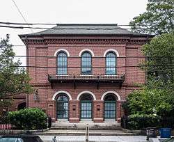
Bristol Customshouse and Post Office |
|
May 31, 1972
(#72000015) |
420-448 Hope St.
41°39′58″N 71°16′31″W / 41.666111°N 71.275278°W / 41.666111; -71.275278 (Bristol Customshouse and Post Office) |
Bristol |
|
| 5 |
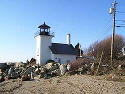
Bristol Ferry Lighthouse |
|
February 25, 1988
(#87001696) |
Ferry Rd.
41°38′35″N 71°15′37″W / 41.643056°N 71.260278°W / 41.643056; -71.260278 (Bristol Ferry Lighthouse) |
Bristol |
|
| 6 |
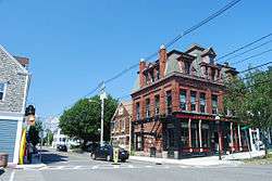
Bristol Waterfront Historic District |
|
March 18, 1975
(#75000053) |
Bristol Harbor to E side of Wood St. as far N as Washington St. and S to Walker Cove
41°40′10″N 71°16′31″W / 41.669444°N 71.275278°W / 41.669444; -71.275278 (Bristol Waterfront Historic District) |
Bristol |
|
| 7 |
Benjamin Church House |
|
September 22, 1971
(#71000011) |
1014 Hope St.
41°41′09″N 71°16′43″W / 41.685833°N 71.278611°W / 41.685833; -71.278611 (Benjamin Church House) |
Bristol |
|
| 8 |
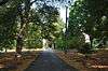
Juniper Hill Cemetery |
|
June 3, 1998
(#98000632) |
24 Sherry Ave.
41°40′53″N 71°16′06″W / 41.681389°N 71.268333°W / 41.681389; -71.268333 (Juniper Hill Cemetery) |
Bristol |
|
| 9 |
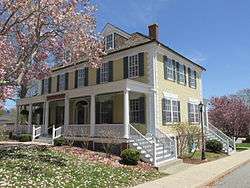
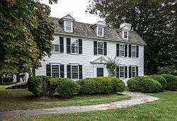
Longfield |
|
July 17, 1972
(#72000016) |
1200 Hope St.
41°41′49″N 71°16′47″W / 41.696944°N 71.279722°W / 41.696944; -71.279722 (Longfield) |
Bristol |
|
| 10 |
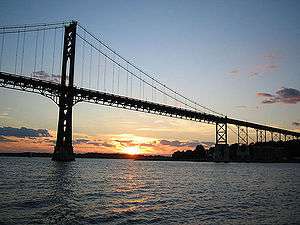
Mount Hope Bridge |
|
January 31, 1976
(#76000038) |
RI 114 over Narragansett Bay
41°38′25″N 71°15′32″W / 41.640278°N 71.258889°W / 41.640278; -71.258889 (Mount Hope Bridge) |
Bristol |
|
| 11 |
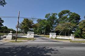
Mount Hope Farm |
|
May 2, 1977
(#77000023) |
Metacom Ave.
41°40′09″N 71°14′50″W / 41.669167°N 71.247222°W / 41.669167; -71.247222 (Mount Hope Farm) |
Bristol |
|
| 12 |
Poppasquash Farms Historic District |
|
June 27, 1980
(#80000075) |
Off RI 114
41°40′45″N 71°17′44″W / 41.679167°N 71.295556°W / 41.679167; -71.295556 (Poppasquash Farms Historic District) |
Bristol |
Includes Colt State Park and adjacent properties. |
| 13 |
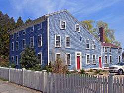
Joseph Reynolds House |
|
May 31, 1972
(#72000017) |
956 Hope St.
41°41′01″N 71°16′46″W / 41.683611°N 71.279444°W / 41.683611; -71.279444 (Joseph Reynolds House) |
Bristol |
Oldest three-story frame house in New England, dating to 1700. Used as headquarters by Lafayette during 1778 Rhode Island campaign. |
_(extra_close)_(US48).svg.png)