National Register of Historic Places listings in North Cascades National Park
This is a list of the National Register of Historic Places listings in North Cascades National Park.
This is intended to be a complete list of the properties and districts on the National Register of Historic Places in North Cascades National Park, Washington, United States. The locations of National Register properties and districts for which the latitude and longitude coordinates are included below, may be seen in a Google map.[1]
There are 15 properties listed on the National Register in the park.
- This National Park Service list is complete through NPS recent listings posted October 11, 2018.[2]
Current listings
| [3] | Name on the Register | Image | Date listed[4] | Location | City or town | Description |
|---|---|---|---|---|---|---|
| 1 | Backus-Marblemount Ranger Station House No. 1009 | 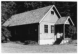 |
February 10, 1989 (#88003462) |
Ranger Station Rd., 1 mi. N of WA 20 48°32′26″N 121°26′55″W / 48.540577°N 121.448684°W |
Marblemount | |
| 2 | Backus-Marblemount Ranger Station House No. 1010 |  |
February 10, 1989 (#88003463) |
Ranger Station Rd., 1 mi. N of WA 20 48°32′27″N 121°26′57″W / 48.540912°N 121.449262°W |
Marblemount | |
| 3 | Beaver Pass Shelter | 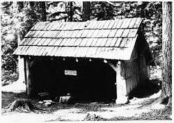 |
February 10, 1989 (#88003448) |
Beaver Pass, 14 mi (23 km). W of Ross Lake 48°52′20″N 121°14′56″W / 48.872222°N 121.248889°W |
Diablo | |
| 4 | Black Warrior Mine | October 15, 1974 (#74000914) |
At end of Horseshoe Basin Trail, about 20.5 miles (33.0 km) northwest of Stehekin 48°28′47″N 121°01′29″W / 48.47969°N 121.0248°W |
Stehekin | ||
| 5 | Bridge Creek Cabin-Ranger Station | February 10, 1989 (#88003458) |
In Bridge Creek Campground, southwest of Stehekin Valley Trail, about 13 miles (21 km) northwest of Stehekin 48°25′47″N 120°52′22″W / 48.42969°N 120.87269°W |
Stehekin | ||
| 6 | Bridge Creek Shelter | 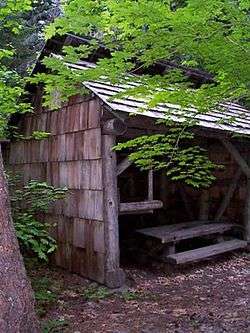 |
February 10, 1989 (#88003445) |
In Bridge Creek Campground, north of Stehekin Valley Trail, about 12.8 miles (20.6 km) northwest of Stehekin 48°25′48″N 120°52′05″W / 48.43009°N 120.86801°W |
Stehekin | |
| 7 | Copper Mountain Fire Lookout | 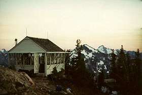 |
February 10, 1989 (#88003446) |
On Copper Mountain, 10 mi (16 km). E of Hannegan Campground 48°54′33″N 121°27′41″W / 48.909167°N 121.461389°W |
Newhalem | |
| 8 | Gilbert's Cabin |  |
February 10, 1989 (#88003453) |
Cascade River Rd. W of Gilbert Creek 48°29′19″N 121°05′20″W / 48.488611°N 121.088889°W |
Stehekin | |
| 9 | International Boundary US-Canada Monuments | February 10, 1989 (#88003450) |
Along US-Canada border between eastern boundary of Ross Lake NRA and western boundary of North Cascades National Park 49°00′04″N 121°31′19″W / 49.001111°N 121.521944°W |
Hozomeen | ||
| 10 | Perry Creek Shelter | 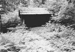 |
February 10, 1989 (#88003447) |
On Little Beaver Trail, 5 mi (8.0 km). W of Ross Lake 48°55′16″N 121°09′21″W / 48.921111°N 121.155833°W |
Hozomeen | |
| 11 | Rock Cabin | 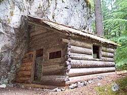 |
February 10, 1989 (#88003457) |
Fisher Creek Trail S of Diablo Lake 48°34′42″N 120°59′47″W / 48.578333°N 120.996389°W |
Diablo | |
| 12 | Sourdough Mountain Lookout | 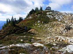 |
February 10, 1989 (#88003449) |
On Sourdough Mountain, 5 mi (8.0 km). NE of Diablo 48°44′34″N 121°06′29″W / 48.742778°N 121.108056°W |
Diablo | |
| 13 | Sulphide-Frisco Cabin | 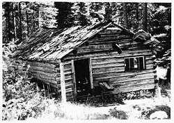 |
February 10, 1989 (#88003459) |
Along Bridge Creek Trail, about 11.5 miles (18.5 km) north of Stehekin 48°28′20″N 120°42′46″W / 48.47225°N 120.71289°W |
Stehekin | |
| 14 | Swamp-Meadow Cabin (east) | 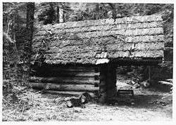 |
February 10, 1989 (#88003456) |
Thunder Creek Trail S of Diablo Lake 48°34′44″N 121°01′05″W / 48.578889°N 121.018056°W |
Diablo | |
| 15 | Swamp-Meadow Cabin (west) | 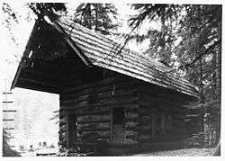 |
February 10, 1989 (#88003455) |
Thunder Creek Trail S of Diablo Lake 48°34′44″N 121°01′05″W / 48.578889°N 121.018056°W |
Diablo |
See also
References
- ↑ The latitude and longitude information provided in this table was derived originally from the National Register Information System, which has been found to be fairly accurate for about 99% of listings. For about 1% of NRIS original coordinates, experience has shown that one or both coordinates are typos or otherwise extremely far off; some corrections may have been made. A more subtle problem causes many locations to be off by up to 150 yards, depending on location in the country: most NRIS coordinates were derived from tracing out latitude and longitudes from USGS topographical quadrant maps created under the North American Datum of 1927, which differs from the current, highly accurate WGS84 GPS system used by most on-line maps. Chicago is about right, but NRIS longitudes in Washington are higher by about 4.5 seconds, and are lower by about 2.0 seconds in Maine. Latitudes differ by about 1.0 second in Florida. Some locations in this table may have been corrected to current GPS standards.
- ↑ "National Register of Historic Places: Weekly List Actions". National Park Service, United States Department of the Interior. Retrieved on October 11, 2018.
- ↑ Numbers represent an ordering by significant words. Various colorings, defined here, differentiate National Historic Landmarks and historic districts from other NRHP buildings, structures, sites or objects.
- ↑ The eight-digit number below each date is the number assigned to each location in the National Register Information System database, which can be viewed by clicking the number.
| Topics | |
|---|---|
| Lists by states |
|
| Lists by insular areas | |
| Lists by associated states | |
| Other areas | |
| |
| Wikimedia Commons has media related to National Register of Historic Places in North Cascades National Park. |
This article is issued from
Wikipedia.
The text is licensed under Creative Commons - Attribution - Sharealike.
Additional terms may apply for the media files.