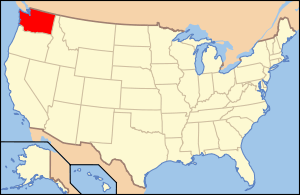
National Register of Historic Places listings in Chelan County, Washington
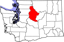
Location of Chelan County in Washington
This is a list of the National Register of Historic Places listings in Chelan County, Washington.
This is intended to be a complete list of the properties and districts on the National Register of Historic Places in Chelan County, Washington, United States. Latitude and longitude coordinates are provided for many National Register properties and districts; these locations may be seen together in a map.[1]
There are 46 properties and districts listed on the National Register in the county. Another property was once listed but has been removed.
- This National Park Service list is complete through NPS recent listings posted October 11, 2018.[2]
Current listings
| [3] | Name on the Register[4] | Image | Date listed[5] | Location | City or town | Description |
|---|---|---|---|---|---|---|
| 1 | Black Warrior Mine | October 15, 1974 (#74000914) |
At end of Horseshoe Basin Trail, about 20.5 miles (33.0 km) northwest of Stehekin, in North Cascades National Park 48°28′47″N 121°01′29″W / 48.47969°N 121.0248°W |
Stehekin | ||
| 2 | Blewett Arrastra | 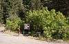 |
September 17, 1974 (#74001941) |
About 11.2 miles (18.0 km) southwest of Cashmere, in Wenatchee National Forest 47°25′21″N 120°39′34″W / 47.42245°N 120.65942°W |
Cashmere | |
| 3 | Bridge Creek Cabin-Ranger Station | February 10, 1989 (#88003458) |
In Bridge Creek Campground, southwest of Stehekin Valley Trail, about 13 miles (21 km) northwest of Stehekin, in North Cascades National Park 48°25′47″N 120°52′22″W / 48.42969°N 120.87269°W |
Stehekin | Included in the North Cascades National Park Service Complex MRA | |
| 4 | Bridge Creek Shelter | 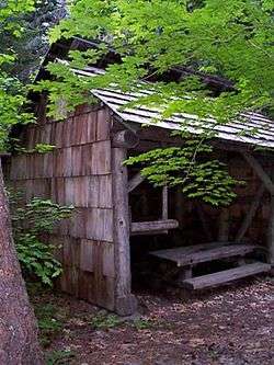 |
February 10, 1989 (#88003445) |
In Bridge Creek Campground, north of Stehekin Valley Trail, about 12.8 miles (20.6 km) northwest of Stehekin, in North Cascades National Park 48°25′48″N 120°52′05″W / 48.43009°N 120.86801°W |
Stehekin | |
| 5 | Buckner Cabin | 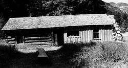 |
May 17, 1974 (#74000912) |
End of Rainbow Lane, about 2.6 miles (4.2 km) northwest of Stehekin, Washington, in Lake Chelan National Recreation Area 48°20′05″N 120°42′04″W / 48.33473°N 120.70115°W |
Stehekin | Also a contributing property to Buckner Homestead Historic District. |
| 6 | Buckner Homestead Historic District | 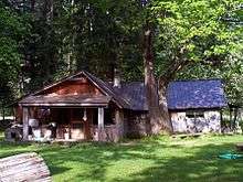 |
February 10, 1989 (#88003441)[6] |
Along Rainbow Lane, about 2.6 miles (4.2 km) northwest of Stehekin, Washington, in Lake Chelan National Recreation Area 48°20′08″N 120°42′03″W / 48.33567°N 120.70082°W |
Stehekin | Originally Address restricted[7], location was disclosed in 2016.[6] |
| 7 | Burbank Homestead Waterwheel | 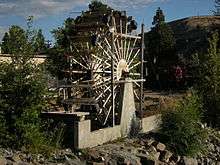 |
June 19, 1973 (#73002277) |
In Cashmere Pioneer Village, 600 Cotlets Way, shortly south of Wenatchee bridge 47°31′13″N 120°27′25″W / 47.52032°N 120.45703°W |
Cashmere | |
| 8 | Chatter Creek Guard Station | 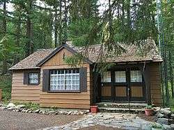 |
April 8, 1986 (#86000812) |
Along Icicle Gorge Loop Trail, Wenatchee National Forest, about 10.5 miles (16.9 km) west of Leavenworth 47°36′27″N 120°53′04″W / 47.60755°N 120.88442°W |
Leavenworth | |
| 9 | Chelan Butte Lookout | 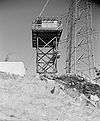 |
December 27, 1990 (#90001912) |
Columbia Breaks Fire Interpretive Center, along US-97, about 1.2 miles (1.9 km) north of Entiat 47°41′41″N 120°12′39″W / 47.69459°N 120.21096°W |
Entiat | Originally located on the summit of Chelan Butte mountain (47°48′24″N 120°02′04″W / 47.8068°N 120.03457°W), it was removed in 1995 and relocated to Entiat in 1996.[8][9] Included in the USDA Forest Service Fire Lookouts on Wenatchee NF MPS |
| 10 | Columbia River Bridge | 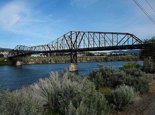 |
July 16, 1982 (#82004198) |
Spans Columbia River between Bridge Street, Wenatchee and 9th Street NE, East Wenatchee 47°24′53″N 120°17′50″W / 47.41461°N 120.29719°W |
Wenatchee | |
| 11 | Senator George Sellar Bridge | 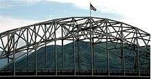 |
May 24, 1995 (#95000623) |
Spans Columbia River on US-2, between Stevens Street, Wenatchee and 5th Street NE, East Wenatchee 47°24′35″N 120°17′44″W / 47.40983°N 120.29568°W |
Wenatchee | |
| 12 | Cottage Avenue Historic District | 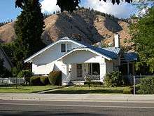 |
December 26, 2002 (#02001617) |
208-509 Cottage Avenue, 103 Maple Street, 107 Parkhill Street 47°31′15″N 120°27′47″W / 47.52097°N 120.46319°W |
Cashmere | 52 contributing properties in 12.47 acres (5.05 ha), located at 208-509 Cottage Avenue, 103 Maple Street and 107 Parkhill Street. |
| 13 | Courtney Cabin | 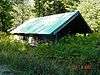 |
May 31, 1974 (#74000910) |
End of Company Creek Road, about 5.7 miles (9.2 km) northwest of Stehekin, Washington, in Lake Chelan National Recreation Area 48°21′54″N 120°45′03″W / 48.36493°N 120.7508°W |
Stehekin | |
| 14 | Downtown Wenatchee Historic District | 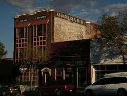 |
December 17, 2008 (#08001200) |
Roughly bounded by North and South Columbia Street, Mission Street, First Street, and Kittitas Street 47°25′24″N 120°18′38″W / 47.42342°N 120.31048°W |
Wenatchee | |
| 15 | Flick Creek Shelter | 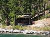 |
February 10, 1989 (#88003444) |
East side of Lake Chelan, south of Flick Creek, about 3.2 miles (5.1 km) southeast of Stehekin, in Lake Chelan National Recreation Area 48°16′11″N 120°37′23″W / 48.2696°N 120.62316°W |
Stehekin | Included in the North Cascades National Park Service Complex MRA |
| 16 | Golden West Lodge Historic District | 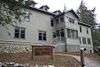 |
February 10, 1989 (#88003442) |
End of Stehekin Valley Road, in Lake Chelan National Recreation Area 48°18′31″N 120°39′23″W / 48.3085°N 120.65641°W |
Stehekin | |
| 17 | High Bridge Ranger Station Historic District | 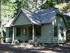 |
February 10, 1989 (#88003443) |
Along Stehekin Valley Road, about 9.6 miles (15.4 km) northwest of Stehekin, in Lake Chelan National Recreation Area 48°22′48″N 120°50′16″W / 48.38013°N 120.83768°W |
Stehekin | Included in the North Cascades National Park Service Complex MRA |
| 18 | High Bridge Shelter | 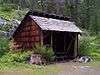 |
February 10, 1989 (#88003461) |
In High Bridge Campground, off Stehekin Valley Road, about 9.7 miles (15.6 km) northwest of Stehekin, in Lake Chelan National Recreation Area 48°22′52″N 120°50′21″W / 48.38113°N 120.83924°W |
Stehekin | Included in the North Cascades National Park Service Complex MRA |
| 19 | Michael Horan House | 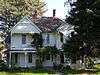 |
March 31, 1992 (#92000281) |
2 Horan Road 47°27′34″N 120°20′05″W / 47.45941°N 120.33459°W |
Wenatchee | Included in the property is the garage building, shortly east of the house. |
| 20 | Lake Chelan Hydroelectric Power Plant | 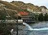 |
December 15, 1988 (#88002739) |
Southwestern end of Lake Chelan to Columbia River 47°49′36″N 120°00′11″W / 47.82664°N 120.00306°W |
Chelan | |
| 21 | Lake Wenatchee Residence No. 1200 | 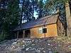 |
March 6, 1991 (#91000158) |
Along Lake Wenatchee Highway, north shore of Lake Wenatchee, about 18 miles (29 km) northwest of Leavenworth, in Wenatchee National Forest 47°50′13″N 120°47′55″W / 47.83691°N 120.79851°W |
Leavenworth | Included in the USDA Forest Service Administrative Buildings in Oregon and Washington Built by the CCC MPS |
| 22 | Leavenworth National Fish Hatchery | 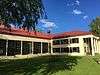 |
July 27, 1998 (#98000847) |
12790 Fish Hatchery Road, about 2.7 miles (4.3 km) south of Leavenworth 47°33′31″N 120°40′30″W / 47.55855°N 120.67493°W |
Leavenworth | |
| 23 | Leavenworth Ranger Station |  |
April 11, 1986 (#86000840) |
600 Sherbourne Street 47°35′55″N 120°39′27″W / 47.59863°N 120.65743°W |
Leavenworth | |
| 24 | Leavenworth Ski Hill Historic District |  |
July 17, 2013 (#13000505) |
10701 Ski Hill Drive, inside the Wenatchee National Forest 47°36′51″N 120°40′13″W / 47.61427°N 120.67027°W |
Leavenworth | |
| 25 | Richard Hinton Lord House | 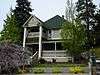 |
March 25, 1999 (#99000404) |
121 East Highland Avenue 47°50′45″N 120°01′03″W / 47.84591°N 120.01761°W |
Chelan | |
| 26 | Lucas Homestead | 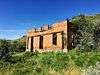 |
December 14, 1978 (#78002734) |
South of Downie Canyon Road, about 4.8 miles (7.7 km) southwest of Chelan 47°48′13″N 120°06′21″W / 47.8036°N 120.10597°W |
Chelan | |
| 27 | Lucerne Guard Station | 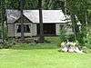 |
March 6, 1991 (#91000160) |
Southern shore of Lake Chelan, in Wenatchee National Forest 48°12′08″N 120°35′25″W / 48.20214°N 120.59036°W |
Lucerne | Included in the USDA Forest Service Administrative Buildings in Oregon and Washington Built by the CCC MPS |
| 28 | George Miller House | 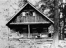 |
February 10, 1989 (#88003464) |
Shortly east of Stehekin Valley Road, in Lake Chelan National Recreation Area 48°18′41″N 120°39′24″W / 48.3115°N 120.65675°W |
Stehekin | |
| 29 | Penstock Bridge |  |
July 16, 1982 (#82004196) |
Spans Wenatchee River, near the Old Pipeline Bed Trailhead, about 2.3 miles (3.7 km) west of Leavenworth, in Wenatchee National Forest 47°35′17″N 120°42′33″W / 47.58794°N 120.70911°W |
Leavenworth | Included in the Historic Bridges/Tunnels in Washington State TR |
| 30 | Purple Point-Stehekin Ranger Station House | 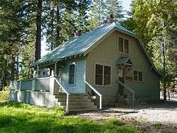 |
February 10, 1989 (#88003460) |
Along Stehekin Valley Road, in Lake Chelan National Recreation Area 48°18′27″N 120°39′19″W / 48.30763°N 120.6553°W |
Stehekin | |
| 31 | Rock Island Railroad Bridge | 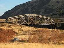 |
July 30, 1975 (#75001842) |
Spans Columbia River about 0.7 miles (1.1 km) southwest of Rock Island 47°22′01″N 120°09′14″W / 47.36701°N 120.1538°W |
Rock Island | |
| 32 | Ruby Theatre | 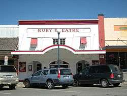 |
October 7, 1991 (#91001495) |
135 East Woodin Avenue 47°50′25″N 120°01′03″W / 47.8402°N 120.01746°W |
Chelan | |
| 33 | St. Andrews Episcopal Church | 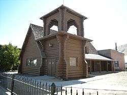 |
March 31, 1992 (#92000283) |
120 East Woodin Avenue 47°50′23″N 120°01′06″W / 47.8397°N 120.01842°W |
Chelan | |
| 34 | Stehekin School | 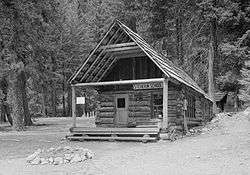 |
May 31, 1974 (#74000913) |
Along Stehekin Valley Road, about 0.25 miles (0.40 km) east of Rainbow Falls road junction, in Lake Chelan National Recreation Area 48°20′27″N 120°41′52″W / 48.34092°N 120.69777°W |
Stehekin | |
| 35 | Steliko Ranger Station | 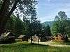 |
March 6, 1991 (#91000159) |
Along Entiat River Road, about 0.6 miles (0.97 km) east of Ardenvoir, in Wenatchee National Forest 47°44′36″N 120°21′40″W / 47.74345°N 120.36124°W |
Ardenvoir | Five contributing buildings in a 3.27 acres (1.32 ha) area. Some of the buildings are no more standing. Included in the USDA Forest Service Administrative Buildings in Oregon and Washington Built by the CCC MPS. |
| 36 | Stevens Pass Guard Station | 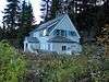 |
March 6, 1991 (#91000156) |
Along US Highway 2, at Stevens Pass, about 13 miles (21 km) east of Skykomish, in Wenatchee National Forest 47°44′44″N 121°05′18″W / 47.74563°N 121.08822°W |
Skykomish | Included in the USDA Forest Service Administrative Buildings in Oregon and Washington Built by the CCC MPS. |
| 37 | Stevens Pass Historic District | 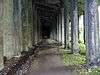 |
October 22, 1976 (#76001884) |
About 22 miles (35 km) from Martin Creek Tunnel in the west to Cascade Tunnel in the east, across Stevens Pass, in Wenatchee National Forest 47°46′15″N 121°00′06″W / 47.77074°N 121.00153°W |
Berne | |
| 38 | Sugarloaf Peak Lookout | December 27, 1990 (#90001914) |
End of Entiat Summit Road, on the summit of Sugarloaf Peak, about 12.7 miles (20.4 km) northwest of Leavenworth, in Wenatchee National Forest 47°45′25″N 120°31′41″W / 47.757°N 120.528°W |
Leavenworth | Included in the USDA Forest Service Fire Lookouts on Wenatchee NF MPS | |
| 39 | Sulphide-Frisco Cabin | 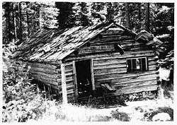 |
February 10, 1989 (#88003459) |
Along Bridge Creek Trail, about 11.5 miles (18.5 km) north of Stehekin, in North Cascades National Park 48°28′20″N 120°42′46″W / 48.47225°N 120.71289°W |
Stehekin | |
| 40 | Tyee Mountain Lookout | December 27, 1990 (#90001913) |
Summit of Tyee Mountain, about 18 miles (29 km) northwest of Entiat, in Wenatchee National Forest 47°51′51″N 120°28′17″W / 47.8642°N 120.47144°W |
Entiat | Included in the USDA Forest Service Fire Lookouts on Wenatchee NF MPS | |
| 41 | U.S. Post Office and Annex | 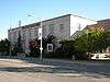 |
May 27, 1977 (#77001331) |
127 South Mission Street 47°25′21″N 120°18′39″W / 47.42247°N 120.31081°W |
Wenatchee | Also contributing properties to Downtown Wenatchee Historic District |
| 42 | Wells House | 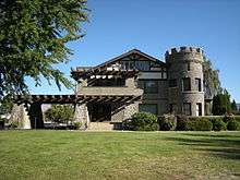 |
June 4, 1973 (#73001865) |
1300 5th Street 47°25′53″N 120°20′01″W / 47.43133°N 120.33359°W |
Wenatchee | |
| 43 | Wenatchee Carnegie Library | 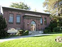 |
August 3, 1982 (#82004199) |
2 South Chelan Avenue 47°25′24″N 120°18′50″W / 47.42332°N 120.31381°W |
Wenatchee | Included in the Carnegie Libraries of Washington TR |
| 44 | Wenatchee Fire Station #1 | 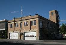 |
September 10, 2004 (#04000953) |
136 South Chelan Avenue 47°25′17″N 120°18′44″W / 47.42135°N 120.31227°W |
Wenatchee | |
| 45 | Wenatchee Flat Site |  |
August 14, 1973 (#73001866) |
Address restricted[7] |
Wenatchee | |
| 46 | West Monitor Bridge |  |
July 16, 1982 (#82004197) |
Spans Wenatchee River on Old Monitor Road 47°30′04″N 120°25′32″W / 47.50102°N 120.42556°W |
Monitor | Included in the Historic Bridges/Tunnels in Washington State TR |
Former listings
| [3] | Name on the Register | Image | Date listed | Date removed | Location | City or town | Summary |
|---|---|---|---|---|---|---|---|
| 1 | Centennial Flour Mill | 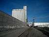 |
December 12, 1976 (#76001877) | July 16, 1990 | 701 South Wenatchee Avenue 47°24′56″N 120°18′10″W / 47.41559°N 120.30289°W |
Wenatchee |
See also
| Wikimedia Commons has media related to National Register of Historic Places in Chelan County, Washington. |
References
- ↑ The latitude and longitude information provided in this table was derived originally from the National Register Information System, which has been found to be fairly accurate for about 99% of listings. For about 1% of NRIS original coordinates, experience has shown that one or both coordinates are typos or otherwise extremely far off; some corrections may have been made. A more subtle problem causes many locations to be off by up to 150 yards, depending on location in the country: most NRIS coordinates were derived from tracing out latitude and longitudes from USGS topographical quadrant maps created under the North American Datum of 1927, which differs from the current, highly accurate WGS84 GPS system used by most on-line maps. Chicago is about right, but NRIS longitudes in Washington are higher by about 4.5 seconds, and are lower by about 2.0 seconds in Maine. Latitudes differ by about 1.0 second in Florida. Some locations in this table may have been corrected to current GPS standards.
- ↑ "National Register of Historic Places: Weekly List Actions". National Park Service, United States Department of the Interior. Retrieved on October 11, 2018.
- 1 2 Numbers represent an ordering by significant words. Various colorings, defined here, differentiate National Historic Landmarks and historic districts from other NRHP buildings, structures, sites or objects.
- ↑ National Park Service (2008-04-24). "National Register Information System". National Register of Historic Places. National Park Service.
- ↑ The eight-digit number below each date is the number assigned to each location in the National Register Information System database, which can be viewed by clicking the number.
- 1 2 National Park Service. "Buckner Homestead Historic District (Amended Documentation)" (PDF). Retrieved June 19, 2017.
- 1 2 Federal and state laws and practices restrict general public access to information regarding the specific location of this resource. In some cases, this is to protect archeological sites from vandalism, while in other cases it is restricted at the request of the owner. See: Knoerl, John; Miller, Diane; Shrimpton, Rebecca H. (1990), Guidelines for Restricting Information about Historic and Prehistoric Resources, National Register Bulletin (29), National Park Service, U.S. Department of the Interior, OCLC 20706997 .
- ↑ "Chelan Butte Lookout Site". Retrieved June 19, 2017.
- ↑ "Chelan Butte". Retrieved June 19, 2017.

| Topics | |
|---|---|
| Lists by states |
|
| Lists by insular areas | |
| Lists by associated states | |
| Other areas | |
| |
Municipalities and communities of Chelan County, Washington, United States | ||
|---|---|---|
| Cities | | |
| CDPs | ||
| Other unincorporated communities | ||
| Indian reservation | ||
| Ghost towns | ||
| Footnotes | ‡This populated place also has portions in an adjacent county or counties | |
This article is issued from
Wikipedia.
The text is licensed under Creative Commons - Attribution - Sharealike.
Additional terms may apply for the media files.