| [1] |
Name on the Register[2] |
Image |
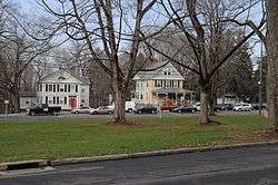
Date listed[3] |
Location |
City or town |
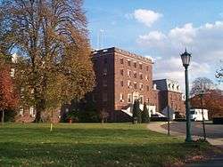
Description |
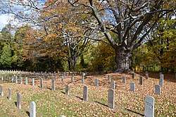
|---|
| 1 |
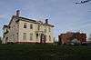
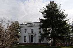
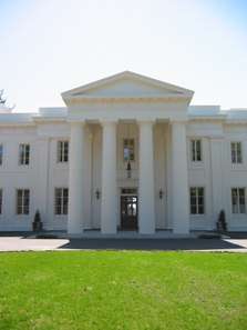
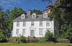
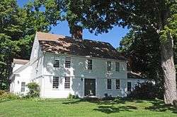
Alsop House |
|
October 6, 1970
(#70000686) |
301 High St.
41°33′30″N 72°39′22″W / 41.558333°N 72.656111°W / 41.558333; -72.656111 (Alsop House) |
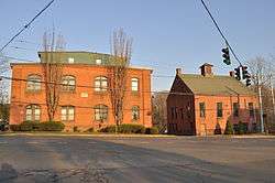
Middletown |
Stately mansion built in "Greek-Tuscan Italianate" style in 1838-39, now owned by Wesleyan University. Designated a National Historic Landmark in 2009. |
| 2 |
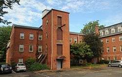
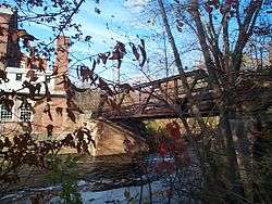
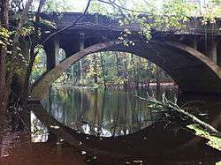
Arrawanna Bridge |
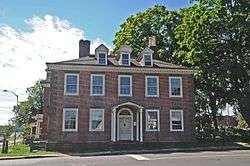
|
September 29, 2004
(#04001092) |
Berlin St. at the Coginchaug River
41°33′46″N 72°40′00″W / 41.562778°N 72.666667°W / 41.562778; -72.666667 (Arrawanna Bridge) |
Middletown |
An early reinforced concrete bridge, of elegant open spandrel design, blocked from use and deteriorating as of 2004 nomination. |
| 3 |
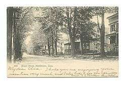
Broad Street Historic District |
|
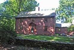
August 25, 1988
(#88001319) |
Roughly bounded by High, Washington, Broad and Church Sts.
41°33′29″N 72°39′10″W / 41.558056°N 72.652778°W / 41.558056; -72.652778 (Broad Street Historic District) |
Middletown |
|
| 4 |
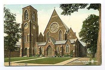
Church of the Holy Trinity and Rectory |
|
August 14, 1979
(#79002615) |
381 Main St. and 144 Broad St.
41°33′40″N 72°39′06″W / 41.561111°N 72.651667°W / 41.561111; -72.651667 (Church of the Holy Trinity and Rectory) |
Middletown |
|
| 5 |
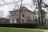
Coite-Hubbard House |
|
December 20, 1978
(#78002846) |
269 High St.
41°33′26″N 72°39′20″W / 41.557222°N 72.655556°W / 41.557222; -72.655556 (Coite-Hubbard House) |
Middletown |
|
| 6 |
Connecticut General Hospital for the Insane |
|
August 29, 1985
(#85001920) |
Silver St. E. of Eastern Dr.
41°33′10″N 72°37′47″W / 41.552778°N 72.629722°W / 41.552778; -72.629722 (Connecticut General Hospital for the Insane) |
Middletown |
|
| 7 |
Connecticut Valley Hospital Cemetery |
|
August 2, 2018
(#100002718) |
S of jct. of Silvermine Rd. & O'Brien Dr.
41°33′12″N 72°37′11″W / 41.5533°N 72.6196°W / 41.5533; -72.6196 (Connecticut Valley Hospital Cemetery) |
Middletown |
|
| 8 |
The Eclectic House |
|
January 2, 2013
(#12001111) |
200 High St., Wesleyan University
41°33′18″N 72°39′15″W / 41.55510°N 72.65419°W / 41.55510; -72.65419 (The Eclectic House) |
Middletown |
|
| 9 |
Highland Historic District |
|
June 28, 1982
(#82003770) |
Atkins St. and Country Club Rd.
41°34′05″N 72°44′16″W / 41.568056°N 72.737778°W / 41.568056; -72.737778 (Highland Historic District) |
Middletown |
|
| 10 |
Nehemiah Hubbard House |
|
May 11, 1982
(#82003771) |
Laurel Grove Rd. and Wadsworth St.
41°32′17″N 72°40′52″W / 41.538056°N 72.681111°W / 41.538056; -72.681111 (Nehemiah Hubbard House) |
Middletown |
|
| 11 |
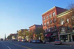
Main Street Historic District (Middletown) |
|
June 30, 1983
(#83001275) |
Roughly Main St. between College and Hartford Ave.
41°33′45″N 72°38′56″W / 41.5625°N 72.648889°W / 41.5625; -72.648889 (Main Street Historic District (Middletown)) |
Middletown |
|
| 12 |
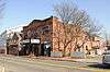
Metro South Historic District |
|
January 24, 1980
(#80004064) |
Main and College Sts.
41°33′27″N 72°38′49″W / 41.5575°N 72.646944°W / 41.5575; -72.646944 (Metro South Historic District) |
Middletown |
|
| 13 |
Middletown Alms House |
|
April 29, 1982
(#82003772) |
53 Warwick St.
41°32′56″N 72°39′09″W / 41.548889°N 72.6525°W / 41.548889; -72.6525 (Middletown Alms House) |
Middletown |
|
| 14 |
Middletown South Green Historic District |
|
August 12, 1975
(#75001922) |
Union Park area, on S. Main, Crescent, Pleasant, and Church Sts.
41°33′21″N 72°38′56″W / 41.555833°N 72.648889°W / 41.555833; -72.648889 (Middletown South Green Historic District) |
Middletown |
|
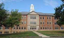
| 15 |
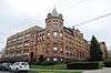
Old Middletown High School |
|
August 23, 1985
(#85001826) |
Pearl and Court Sts.
41°33′30″N 72°39′13″W / 41.558333°N 72.653611°W / 41.558333; -72.653611 (Old Middletown High School) |
Middletown |
|
| 16 |
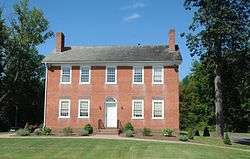
Jacob Pledger House |
|
March 15, 1982
(#82003773) |
717 Newfield St.
41°34′43″N 72°40′22″W / 41.578554°N 72.672897°W / 41.578554; -72.672897 (Jacob Pledger House) |
Middletown |
|
| 17 |
Plumb House |
|
December 1, 1978
(#78002848) |
West of Middletown at 872 Westfield St.
41°33′49″N 72°42′06″W / 41.563611°N 72.701667°W / 41.563611; -72.701667 (Plumb House) |
Middletown |
|
| 18 |
Russell Company Upper Mill |
|
February 6, 1986
(#86000150) |
475 E. Main St.
41°32′37″N 72°38′20″W / 41.543611°N 72.638889°W / 41.543611; -72.638889 (Russell Company Upper Mill) |
Middletown |
|
| 19 |
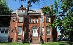
Edward Augustus Russell House |
|
April 29, 1982
(#82004336) |
318 High St.
41°33′32″N 72°39′20″W / 41.558889°N 72.655556°W / 41.558889; -72.655556 (Edward Augustus Russell House) |
Middletown |
Later ΚΝΚ fraternity, now offices of University Relations, Wesleyan University |
| 20 |
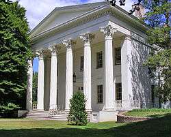
Samuel Wadsworth Russell House |
|
October 6, 1970
(#70000688) |
350 High St.
41°33′37″N 72°39′20″W / 41.560278°N 72.655556°W / 41.560278; -72.655556 (Samuel Wadsworth Russell House) |
Middletown |
Greek revival mansion, designed by Ithiel Town; now part of Wesleyan University. |
| 21 |
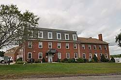
Saint Luke's Home for Destitute and Aged Women |
|
April 29, 1982
(#82004337) |
135 Pearl St.
41°33′42″N 72°39′17″W / 41.561667°N 72.654861°W / 41.561667; -72.654861 (Saint Luke's Home for Destitute and Aged Women) |
Middletown |
|
| 22 |
Sanseer Mill |
|
July 31, 1986
(#86002101) |
215 E. Main St.
41°32′59″N 72°38′31″W / 41.549722°N 72.641944°W / 41.549722; -72.641944 (Sanseer Mill) |
Middletown |
|
| 23 |
Starr Mill |
|
December 14, 1993
(#93001379) |
Junction of Middlefield St. and Beverly Heights
41°32′55″N 72°41′28″W / 41.548611°N 72.691111°W / 41.548611; -72.691111 (Starr Mill) |
Middletown |
|
| 24 |
Starr Mill Road Bridge |
|
December 10, 1993
(#93001344) |
Starr Mill Rd. across the Cochinaug River
41°32′56″N 72°40′38″W / 41.548889°N 72.677222°W / 41.548889; -72.677222 (Starr Mill Road Bridge) |
Middletown |
|
| 25 |
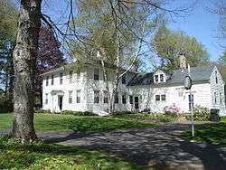
Town Farms Inn |
|
May 4, 1979
(#79002614) |
Spring St. at River Rd.
41°33′28″N 72°37′20″W / 41.557778°N 72.622222°W / 41.557778; -72.622222 (Town Farms Inn) |
Middletown |
|
| 26 |
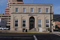
U.S. Post Office |
|
April 12, 1982
(#82004338) |
291 Main St.
41°33′36″N 72°39′01″W / 41.56°N 72.650278°W / 41.56; -72.650278 (U.S. Post Office) |
Middletown |
|
| 27 |
Wadsworth Estate Historic District |
|
July 25, 1996
(#96000775) |
15, 30, 33, 59, 73, and 89 Laurel Grove Rd., Wadsworth Falls State Park, and 421 Wadsworth St.
41°32′02″N 72°40′44″W / 41.533889°N 72.678889°W / 41.533889; -72.678889 (Wadsworth Estate Historic District) |
Middletown |
|
| 28 |
Washington Street Historic District |
|
May 9, 1985
(#85001018) |
Roughly bounded by Washington and Main Sts., Washington Terrace, and Vine St.
41°33′41″N 72°39′31″W / 41.561389°N 72.658611°W / 41.561389; -72.658611 (Washington Street Historic District) |
Middletown |
|
| 29 |
Seth Wetmore House |
|
September 10, 1970
(#70000689) |
CT 66 and Camp Rd.
41°33′09″N 72°41′19″W / 41.5525°N 72.688611°W / 41.5525; -72.688611 (Seth Wetmore House) |
Middletown |
|
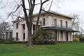
| 30 |
Wilcox, Crittenden Mill |
|
December 3, 1986
(#86003349) |
234-315 S. Main St., Pameacha, and Highlands Aves.
41°32′54″N 72°39′19″W / 41.548333°N 72.655278°W / 41.548333; -72.655278 (Wilcox, Crittenden Mill) |
Middletown |
|
| 31 |
Captain Benjamin Williams House |
|
December 1, 1978
(#09000143) |
27 Washington St.,
41°33′47″N 72°38′54″W / 41.563003°N 72.648428°W / 41.563003; -72.648428 (Captain Benjamin Williams House) |
Middletown |
|
| 32 |
Woodrow Wilson High School |
|
August 6, 1986
(#86002270) |
Hunting Hill Ave. and Russell St.
41°32′25″N 72°38′57″W / 41.540278°N 72.649167°W / 41.540278; -72.649167 (Woodrow Wilson High School) |
Middletown |
|
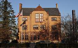
| 33 |
Xi Chapter, Psi Upsilon Fraternity |
|
November 4, 2009
(#09000870) |
242 High St.
41°33′24″N 72°39′18″W / 41.556689°N 72.654908°W / 41.556689; -72.654908 (Xi Chapter, Psi Upsilon Fraternity) |
Middletown |
|
.jpg)