| [2] |
Name on the Register |
Image |
Date listed[3] |
Location |
City or town |
Description |
|---|
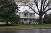
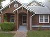
| 1 |
Acoa |
|
June 22, 1982
(#82002446) |
Mathis Rd.
34°39′05″N 83°28′15″W / 34.651389°N 83.470833°W / 34.651389; -83.470833 (Acoa) |
Hollywood |
|
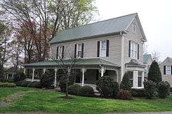
| 2 |
Henry Asbury House |
|
August 18, 1982
(#82002425) |
211 E. Waters St.
34°37′01″N 83°31′26″W / 34.616944°N 83.523889°W / 34.616944; -83.523889 (Henry Asbury House) |
Clarkesville |
|
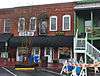
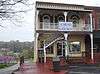
| 3 |
Baron-York Building |
|
August 18, 1982
(#82002426) |
714 N. Washington St.
34°36′56″N 83°31′34″W / 34.615556°N 83.526111°W / 34.615556; -83.526111 (Baron-York Building) |
Clarkesville |
|
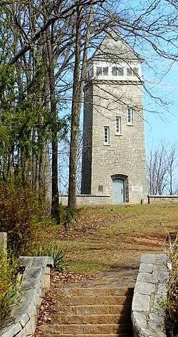
| 4 |
Chenocetah Fire Tower |
|
June 11, 1984
(#84001110) |
Chenocetah Mountain
34°30′08″N 83°30′25″W / 34.502222°N 83.506944°W / 34.502222; -83.506944 (Chenocetah Fire Tower) |
Cornelia |
|
| 5 |
Church Furniture Store |
|
August 18, 1982
(#82002427) |
N. Washington St.
34°36′53″N 83°31′32″W / 34.614722°N 83.525556°W / 34.614722; -83.525556 (Church Furniture Store) |
Clarkesville |
|
| 6 |
Clarkesville Garage |
|
August 18, 1982
(#82002429) |
304 N. Washington St.
34°36′52″N 83°31′32″W / 34.614444°N 83.525556°W / 34.614444; -83.525556 (Clarkesville Garage) |
Clarkesville |
|
| 7 |
Cornelius Church House |
|
August 18, 1982
(#82002428) |
304 N. Washington St.
34°36′52″N 83°31′31″W / 34.614444°N 83.525278°W / 34.614444; -83.525278 (Cornelius Church House) |
Clarkesville |
|
| 8 |
Cornelia Community House |
|
June 21, 1982
(#82002445) |
U.S. 123 at LaVista Lane
34°30′47″N 83°31′08″W / 34.513056°N 83.518889°W / 34.513056; -83.518889 (Cornelia Community House) |
Cornelia |
|
| 9 |
Daes Chapel Methodist Church |
|
August 18, 1982
(#82002430) |
N. Washington St.
34°36′56″N 83°31′41″W / 34.615556°N 83.528056°W / 34.615556; -83.528056 (Daes Chapel Methodist Church) |
Clarkesville |
|
| 10 |
Demorest Commercial Historic District |
|
October 16, 1989
(#89001713) |
Georgia St. and Central Ave.
34°33′54″N 83°32′43″W / 34.565°N 83.545278°W / 34.565; -83.545278 (Demorest Commercial Historic District) |
Demorest |
|
| 11 |
Demorest Women's Club |
|
December 30, 2008
(#08001247) |
1035 Central Ave.
34°33′59″N 83°32′39″W / 34.5664°N 83.5443°W / 34.5664; -83.5443 (Demorest Women's Club) |
Demorest |
|
| 12 |
Furr-Lambert House |
|
August 18, 1982
(#82002431) |
223 Grant St.
34°37′06″N 83°31′27″W / 34.618333°N 83.524167°W / 34.618333; -83.524167 (Furr-Lambert House) |
Clarkesville |
|
| 13 |
Glen-Ella Springs Hotel |
|
January 4, 1990
(#89002270) |
SW of Tallulah Falls on Co. Rd. 218
34°43′12″N 83°26′54″W / 34.72°N 83.448333°W / 34.72; -83.448333 (Glen-Ella Springs Hotel) |
Turnerville |
|
| 14 |
Grace Church |
|
February 15, 1980
(#80001087) |
Wilson and Greene Sts.
34°36′58″N 83°31′24″W / 34.616111°N 83.523333°W / 34.616111; -83.523333 (Grace Church) |
Clarkesville |
|
| 15 |
Griggs-Erwin House |
|
August 18, 1982
(#82002432) |
Bridge St.
34°37′02″N 83°31′37″W / 34.617222°N 83.526944°W / 34.617222; -83.526944 (Griggs-Erwin House) |
Clarkesville |
|
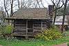
| 16 |
Haywood English Family Log House |
|
December 19, 1991
(#91001852) |
GA 115 W of jct. with Habersham Rd.
34°36′25″N 83°34′26″W / 34.606944°N 83.573889°W / 34.606944; -83.573889 (Haywood English Family Log House) |
Clarkesville |
|
| 17 |
A. P. Hill House |
|
August 18, 1982
(#82002433) |
N. Washington St.
34°36′48″N 83°31′30″W / 34.613333°N 83.525°W / 34.613333; -83.525 (A. P. Hill House) |
Clarkesville |
|
| 18 |
Irvin General Merchandise Store |
|
July 26, 1984
(#84001113) |
Irvin St.
34°30′40″N 83°31′40″W / 34.511111°N 83.527778°W / 34.511111; -83.527778 (Irvin General Merchandise Store) |
Cornelia |
|
| 19 |
Jackson Building |
|
August 18, 1982
(#82002434) |
710 N. Washington St.
34°36′56″N 83°31′33″W / 34.615556°N 83.525833°W / 34.615556; -83.525833 (Jackson Building) |
Clarkesville |
|
| 20 |
Jackson Pharmacy |
|
August 18, 1982
(#82002435) |
712 N. Washington St.
34°36′56″N 83°31′34″W / 34.615556°N 83.526111°W / 34.615556; -83.526111 (Jackson Pharmacy) |
Clarkesville |
|
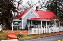
| 21 |
Lawton Place |
|
January 8, 2009
(#08001282) |
136 7th St.
34°31′01″N 83°29′58″W / 34.5170°N 83.4995°W / 34.5170; -83.4995 (Lawton Place) |
Mount Airy |
|
| 22 |
J. A. Lewis House |
|
August 18, 1982
(#82002436) |
N. Washington St.
34°36′48″N 83°31′27″W / 34.613333°N 83.524167°W / 34.613333; -83.524167 (J. A. Lewis House) |
Clarkesville |
|
| 23 |
Loudermilk Boarding House |
|
February 9, 2001
(#01000079) |
271 Foreacre St.
34°30′42″N 83°31′28″W / 34.511667°N 83.524444°W / 34.511667; -83.524444 (Loudermilk Boarding House) |
Cornelia |
|
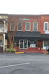
| 24 |
Market Building |
|
August 18, 1982
(#82002437) |
N. Washington St.
34°36′56″N 83°31′41″W / 34.615556°N 83.528056°W / 34.615556; -83.528056 (Market Building) |
Clarkesville |
|
| 25 |
Mauldin House |
|
August 18, 1982
(#82002438) |
102 E. Water St.
34°36′56″N 83°31′31″W / 34.615556°N 83.525278°W / 34.615556; -83.525278 (Mauldin House) |
Clarkesville |
|
| 26 |
Robert McMillan House |
|
August 18, 1982
(#82002439) |
Allen Lane
34°36′20″N 83°31′08″W / 34.605556°N 83.518889°W / 34.605556; -83.518889 (Robert McMillan House) |
Clarkesville |
|
| 27 |
McMillan-Garrison House |
|
August 18, 1982
(#82002440) |
403 S. Washington St.
34°36′16″N 83°31′11″W / 34.604444°N 83.519722°W / 34.604444; -83.519722 (McMillan-Garrison House) |
Clarkesville |
|
| 28 |
Olgetree Farm |
|
July 9, 1997
(#97000753) |
Jct. of Pea Ridge Rd. and Paradise Park Rd.
34°32′21″N 83°35′44″W / 34.539167°N 83.595556°W / 34.539167; -83.595556 (Olgetree Farm) |
View |
|
| 29 |
Porter-York House |
|
August 18, 1982
(#82002441) |
Bridge St.
34°37′03″N 83°31′38″W / 34.6175°N 83.527222°W / 34.6175; -83.527222 (Porter-York House) |
Clarkesville |
|
| 30 |
Pyle-Davis House |
|
June 23, 2003
(#03000537) |
202 Massachusetts Bvd.
34°33′53″N 83°32′34″W / 34.564722°N 83.542778°W / 34.564722; -83.542778 (Pyle-Davis House) |
Demorest |
|
| 31 |
Reeves Building |
|
August 18, 1982
(#82002442) |
N. Washington St.
34°36′53″N 83°31′37″W / 34.614722°N 83.526944°W / 34.614722; -83.526944 (Reeves Building) |
Clarkesville |
|
| 32 |
South Washington Street Historic District |
|
August 18, 1982
(#82002443) |
S. Washington St. between Laurel Dr. and Spring St.
34°36′26″N 83°31′17″W / 34.607222°N 83.521389°W / 34.607222; -83.521389 (South Washington Street Historic District) |
Clarkesville |
|
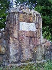
| 33 |
Tallulah Falls School |
|
January 30, 1992
(#91002026) |
Jct. of US 441 and Tallulah School Rd.
34°43′54″N 83°23′36″W / 34.731667°N 83.393333°W / 34.731667; -83.393333 (Tallulah Falls School) |
Tallulah Falls |
|
| 34 |
Washington-Jefferson Street Historic District |
|
August 18, 1982
(#82002444) |
Washington, Jefferson, and Wilson Sts. between Green St. and Laurel Dr.
34°36′49″N 83°31′21″W / 34.613611°N 83.5225°W / 34.613611; -83.5225 (Washington-Jefferson Street Historic District) |
Clarkesville |
|
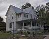
| 35 |
Woodlands and Blythewood |
|
December 30, 1975
(#75002121) |
3 mi. N of Clarkesville off U.S. 441
34°39′00″N 83°29′54″W / 34.65°N 83.498333°W / 34.65; -83.498333 (Woodlands and Blythewood) |
Clarkesville |
|
%2C_HABERSHAM_COUNTY.jpg)