Mount Airy, Georgia
| Mount Airy, Georgia | |
|---|---|
| Town | |
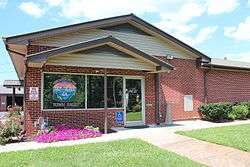 Mount Airy Town Hall | |
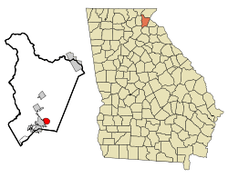 Location in Habersham County and the state of Georgia | |
| Coordinates: 34°31′3″N 83°30′22″W / 34.51750°N 83.50611°WCoordinates: 34°31′3″N 83°30′22″W / 34.51750°N 83.50611°W | |
| Country | United States |
| State | Georgia |
| County | Habersham |
| Area | |
| • Total | 2.59 sq mi (6.70 km2) |
| • Land | 2.58 sq mi (6.68 km2) |
| • Water | 0.008 sq mi (0.02 km2) |
| Elevation | 1,545 ft (471 m) |
| Population (2010) | |
| • Total | 1,284 |
| • Estimate (2016)[1] | 1,300 |
| • Density | 498/sq mi (192.1/km2) |
| Time zone | UTC-5 (Eastern (EST)) |
| • Summer (DST) | UTC-4 (EDT) |
| ZIP code | 30563 |
| Area code(s) | 706 |
| FIPS code | 13-53284[2] |
| GNIS feature ID | 0332428[3] |
| Website |
townofmtairy |
Mount Airy is a town in Habersham County, Georgia, United States. The population was 1,284 at the 2010 census,[4] up from 604 at the 2000 census.
History
The town of Mount Airy was founded on March 3, 1874. It began primarily as a summer retreat for wealthy residents of Atlanta and Savannah. There was once a grand hotel called the Monterrey where the current City Hall stands. Many wealthy families came to the hotel to seek refuge from the heat and from the large populations of malaria-carrying mosquitoes. Mount Airy was a popular tourist destination with many families eventually establishing homes in the area.
A grand, white-columned home on Seventh Street was once the home of baseball legend Ty Cobb. He lived in the home for some time after his retirement. The house still stands as a private residence and is listed in the National Register of Historic Places. Mount Airy was also the hometown of the nation's longest serving elected state official, Tommy Irvin, the late state agriculture commissioner.
Geography
Mount Airy is located in southern Habersham County at 34°31′03″N 83°30′22″W / 34.517638°N 83.506177°W.[5] It is bordered to the west by the city of Cornelia and to the south by Chattahoochee National Forest. The town sits on top of the Eastern Continental Divide, with Camp Creek, draining the northern half of town, flowing north to Hazel Creek and the Soquee River, a tributary of the Chattahoochee River, and ultimately the Gulf of Mexico, while the southern half of town drains to Nancy Town Creek, then the Middle Fork of the Broad River and eventually the Savannah River, which flows to the Atlantic Ocean.
According to the United States Census Bureau, the town has a total area of 2.6 square miles (6.7 km2), of which 0.01 square miles (0.02 km2), or 0.31%, are water.[4] At 1,539 feet (469 m) above sea level, Mount Airy is the highest point on the Southern Railway line between New Orleans and Washington, D.C.. This is confirmed by a US Geological survey marker located on the tracks just behind the City Hall.
Demographics
| Historical population | |||
|---|---|---|---|
| Census | Pop. | %± | |
| 1880 | 112 | — | |
| 1890 | 201 | 79.5% | |
| 1900 | 310 | 54.2% | |
| 1910 | 256 | −17.4% | |
| 1920 | 343 | 34.0% | |
| 1930 | 354 | 3.2% | |
| 1940 | 437 | 23.4% | |
| 1950 | 416 | −4.8% | |
| 1960 | 417 | 0.2% | |
| 1970 | 463 | 11.0% | |
| 1980 | 670 | 44.7% | |
| 1990 | 543 | −19.0% | |
| 2000 | 604 | 11.2% | |
| 2010 | 1,284 | 112.6% | |
| Est. 2016 | 1,300 | [1] | 1.2% |
| U.S. Decennial Census[6] | |||
As of the census[2] of 2000, there were 604 people, 235 households, and 179 families residing in the town. The population density was 323.3 people per square mile (124.7/km²). There were 256 housing units at an average density of 137.0 per square mile (52.9/km²). The racial makeup of the town was 92.38% White, 2.32% African American, 0.17% Native American, 2.81% Asian, 0.99% from other races, and 1.32% from two or more races. Hispanic or Latino of any race were 2.65% of the population.
There were 235 households out of which 30.6% had children under the age of 18 living with them, 58.7% were married couples living together, 11.9% had a female householder with no husband present, and 23.8% were non-families. 21.3% of all households were made up of individuals and 7.7% had someone living alone who was 65 years of age or older. The average household size was 2.57 and the average family size was 2.95.
In the town, the population was spread out with 23.2% under the age of 18, 8.3% from 18 to 24, 31.0% from 25 to 44, 23.2% from 45 to 64, and 14.4% who were 65 years of age or older. The median age was 38 years. For every 100 females, there were 105.4 males. For every 100 females age 18 and over, there were 100.0 males.
The median income for a household in the town was $42,813, and the median income for a family was $45,375. Males had a median income of $27,083 versus $23,500 for females. The per capita income for the town was $18,493. About 3.5% of families and 4.8% of the population were below the poverty line, including 3.9% of those under age 18 and 2.8% of those age 65 or over.
References
- 1 2 "Population and Housing Unit Estimates". Retrieved June 9, 2017.
- 1 2 "American FactFinder". United States Census Bureau. Retrieved 2008-01-31.
- ↑ "US Board on Geographic Names". United States Geological Survey. 2007-10-25. Retrieved 2008-01-31.
- 1 2 "Geographic Identifiers: 2010 Demographic Profile Data (G001): Mount Airy town, Georgia". American Factfinder. U.S. Census Bureau. Retrieved May 16, 2017.
- ↑ "US Gazetteer files: 2010, 2000, and 1990". United States Census Bureau. 2011-02-12. Retrieved 2011-04-23.
- ↑ "Census of Population and Housing". Census.gov. Retrieved June 4, 2015.
Municipalities and communities of Habersham County, Georgia, United States | ||
|---|---|---|
| Cities | 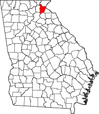 | |
| Towns | ||
| CDP | ||
| Unincorporated communities | ||
| Footnotes | ‡This populated place also has portions in an adjacent county or counties | |