Chelan Falls, Washington
| Chelan Falls, Washington | |
|---|---|
| Census-designated place | |
 Chelan Falls | |
| Coordinates: 47°48′05″N 119°59′09″W / 47.80139°N 119.98583°WCoordinates: 47°48′05″N 119°59′09″W / 47.80139°N 119.98583°W | |
| Country | United States |
| State | Washington |
| County | Chelan |
| Area | |
| • Total | 0.28 sq mi (0.72 km2) |
| • Land | 0.28 sq mi (0.72 km2) |
| • Water | 0.0 sq mi (0.0 km2) |
| Elevation | 732 ft (223 m) |
| Population (2010) | |
| • Total | 329 |
| • Density | 1,178/sq mi (454.9/km2) |
| Time zone | UTC-8 (Pacific (PST)) |
| • Summer (DST) | UTC-7 (PDT) |
| ZIP code | 98817 |
| Area code(s) | 509 |
| GNIS feature ID | 1517645[1] |
Chelan Falls is a census-designated place and unincorporated community in Chelan County, Washington, United States. The population was 329 at the 2010 census.[2] Chelan Falls is located on the Columbia River at the mouth of the Chelan River, 5 miles (8 km) south-southeast of Chelan. Chelan Falls has a post office with ZIP code 98817.[3]
References
- ↑ U.S. Geological Survey Geographic Names Information System: Chelan Falls, Washington
- ↑ "Geographic Identifiers: 2010 Demographic Profile Data (G001): Chelan Falls CDP, Washington". U.S. Census Bureau, American Factfinder. Retrieved August 26, 2015.
- ↑ ZIP Code Lookup Archived September 12, 2012, at the Wayback Machine.
Municipalities and communities of Chelan County, Washington, United States | ||
|---|---|---|
| Cities | 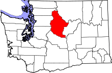 | |
| CDPs | ||
| Other unincorporated communities | ||
| Indian reservation | ||
| Ghost towns | ||
| Footnotes | ‡This populated place also has portions in an adjacent county or counties | |
This article is issued from
Wikipedia.
The text is licensed under Creative Commons - Attribution - Sharealike.
Additional terms may apply for the media files.