National Register of Historic Places listings in Beaverhead County, Montana
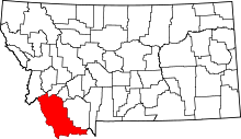
Location of Beaverhead County in Montana
This is a list of the National Register of Historic Places listings in Beaverhead County, Montana. It is intended to be a complete list of the properties and districts on the National Register of Historic Places in Beaverhead County, Montana, United States. The locations of National Register properties and districts for which the latitude and longitude coordinates are included below, may be seen in a map.[1]
There are 19 properties and districts listed on the National Register in the county, including 2 National Historic Landmarks.
- This National Park Service list is complete through NPS recent listings posted October 11, 2018.[2]
Listings county-wide
| [3] | Name on the Register | Image | Date listed[4] | Location | City or town | Description |
|---|---|---|---|---|---|---|
| 1 | Bannack Historic District | 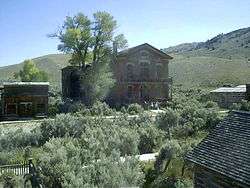 |
October 15, 1966 (#66000426) |
22 miles from Dillon off Montana Highway 278 45°08′40″N 112°58′15″W / 45.144444°N 112.970833°W |
Dillon | |
| 2 | Barrett Hospital | January 18, 1985 (#85000109) |
Chapman and S. Atlantic Sts. 45°12′28″N 112°38′29″W / 45.207778°N 112.641389°W |
Dillon | ||
| 3 | Martin Barrett House | 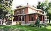 |
January 28, 1987 (#86003675) |
733 S. Pacific 45°12′39″N 112°38′25″W / 45.210833°N 112.640278°W |
Dillon | |
| 4 | Big Hole National Battlefield | 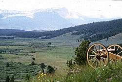 |
October 15, 1966 (#66000427) |
12 miles west of Wisdom 45°38′49″N 113°38′56″W / 45.646944°N 113.648889°W |
Wisdom | |
| 5 | Birch Creek CCC Camp | December 7, 1982 (#82000591) |
North of Dillon on United States Forest Service Road 98 45°24′51″N 112°51′22″W / 45.414167°N 112.856111°W |
Dillon | ||
| 6 | Browne's Bridge | January 4, 2010 (#09001179) |
Browne's Bridge Fishing Access Site 45°32′50″N 112°41′36″W / 45.547311°N 112.693367°W |
Glen | ||
| 7 | Canyon Creek Charcoal Kilns | 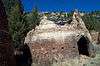 |
June 2, 2005 (#05000511) |
Approximately 5 miles northwest of Glendale on United States Forest Service Road 187 45°40′58″N 112°52′07″W / 45.682778°N 112.868611°W |
Glendale | |
| 8 | Clark's Lookout, August 13, 1805 | _-_Beaverhead_County%2C_Montana.png) |
March 10, 1994 (#94000136) |
Western side of U.S. Route 91, 500 feet north of the Beaverhead River 45°14′06″N 112°37′57″W / 45.235°N 112.6325°W |
Dillon | |
| 9 | Dillon City Library | _-_Beaverhead_County%2C_Montana.png) |
November 14, 1978 (#78001679) |
121 S. Idaho St. 45°12′59″N 112°38′13″W / 45.216389°N 112.636944°W |
Dillon | |
| 10 | Elkhorn-Coolidge Historic District | 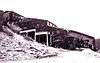 |
September 12, 2008 (#08000884) |
United States Forest Service Road 2465, approximately four miles southeast of its junction with Montana Highway 43 45°29′41″N 113°02′29″W / 45.4948°N 113.0414°W |
Wise River | Includes the Elkhorn mine site and the adjoining ghost town of Coolidge. |
| 11 | Hecla House | August 10, 2005 (#05000885) |
Approximately 11 miles west of Glendale on Trapper Creek Rd. 188 45°36′13″N 112°55′44″W / 45.603611°N 112.928889°W |
Melrose | ||
| 12 | Hotel Metlen | 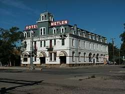 |
December 13, 1983 (#83003978) |
5 S. Railroad Ave. 45°13′06″N 112°37′55″W / 45.218333°N 112.631944°W |
Dillon | |
| 13 | Lamarche Game Trap | September 28, 1976 (#76001117) |
Sugarloaf Mountain, north of Dillon[5]:174 45°30′12″N 112°47′50″W / 45.503333°N 112.797222°W |
Dillon | Likely created by the Shoshone[5]:178 | |
| 14 | Lemhi Pass | 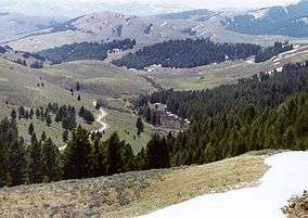 |
October 15, 1966 (#66000313) |
West of Grant, in the Beaverhead and Salmon National Forests 44°58′04″N 113°27′23″W / 44.967778°N 113.456389°W |
Grant | Extends into Lemhi County, Idaho |
| 15 | Montana State Normal School | 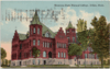 |
August 27, 1980 (#80002398) |
710 S. Atlantic St. 45°12′33″N 112°38′22″W / 45.209167°N 112.639444°W |
Dillon | |
| 16 | Oregon Short Line Passenger Depot | _-_Beaverhead_County%2C_Montana.png) |
April 19, 1990 (#90000628) |
S. Montana St. 45°13′00″N 112°38′18″W / 45.216667°N 112.638333°W |
Dillon | |
| 17 | Sheep Creek Wickiup Cave | September 23, 1981 (#81000338) |
Address Restricted |
Lima | ||
| 18 | US Post Office-Dillon Main | _-_Beaverhead_County%2C_Montana.png) |
March 14, 1986 (#86000683) |
117 S. Idaho St. 45°12′57″N 112°38′15″W / 45.215833°N 112.6375°W |
Dillon | |
| 19 | Van Camp-Tash Ranch | April 16, 2008 (#08000312) |
1200 Montana Highway 278 45°10′51″N 112°42′01″W / 45.180972°N 112.700153°W |
Dillon |
See also
| Wikimedia Commons has media related to National Register of Historic Places in Beaverhead County, Montana. |
References
- ↑ The latitude and longitude information provided in this table was derived originally from the National Register Information System, which has been found to be fairly accurate for about 99% of listings. For about 1% of NRIS original coordinates, experience has shown that one or both coordinates are typos or otherwise extremely far off; some corrections may have been made. A more subtle problem causes many locations to be off by up to 150 yards, depending on location in the country: most NRIS coordinates were derived from tracing out latitude and longitudes from USGS topographical quadrant maps created under the North American Datum of 1927, which differs from the current, highly accurate WGS84 GPS system used by most on-line maps. Chicago is about right, but NRIS longitudes in Washington are higher by about 4.5 seconds, and are lower by about 2.0 seconds in Maine. Latitudes differ by about 1.0 second in Florida. Some locations in this table may have been corrected to current GPS standards.
- ↑ "National Register of Historic Places: Weekly List Actions". National Park Service, United States Department of the Interior. Retrieved on October 11, 2018.
- ↑ Numbers represent an ordering by significant words. Various colorings, defined here, differentiate National Historic Landmarks and historic districts from other NRHP buildings, structures, sites or objects.
- ↑ The eight-digit number below each date is the number assigned to each location in the National Register Information System database, which can be viewed by clicking the number.
- 1 2 Keyser, James D. "The LaMarche Game Trap: An Early Historic Game Trap in Southwestern Montana". Plains Anthropologist 19.65 (1974): 173-179.
| Topics | |
|---|---|
| Lists by states |
|
| Lists by insular areas | |
| Lists by associated states | |
| Other areas | |
| |
Municipalities and communities of Beaverhead County, Montana, United States | ||
|---|---|---|
| City | | |
| Town | ||
| CDP | ||
| Ghost towns | ||
| Unincorporated communities | ||
This article is issued from
Wikipedia.
The text is licensed under Creative Commons - Attribution - Sharealike.
Additional terms may apply for the media files.