Namtok Pha Charoen National Park
| Namtok Pha Charoen National Park | |
|---|---|
| อุทยานแห่งชาติน้ำตกพาเจริญ | |
|
IUCN category II (national park) | |
 Namtok Pha Charoen | |
 Park location in Thailand | |
| Location | Tak Province, Thailand |
| Nearest city | Tak |
| Coordinates | 16°30′28.879″N 98°42′11.105″E / 16.50802194°N 98.70308472°ECoordinates: 16°30′28.879″N 98°42′11.105″E / 16.50802194°N 98.70308472°E |
| Area | 855 km2 (330 sq mi) |
| Governing body | Department of National Parks, Wildlife and Plant Conservation |
Namtok Pha Charoen National Park (Thai: อุทยานแห่งชาติน้ำตกพาเจริญ) is a national park in the Phop Phra District, Tak Province, Thailand. Most of its area is high complex mountains of 1,765 m elevation and features a mixed deciduous forest and a coniferous forest.[1]
Geography
Namtok Pha Charoen National Park is west of Tak town. The park's area is 855 square kilometres (330 sq mi) (534,375 rai).[2]
Climate
As the area of the national park is affected by the southwestern monsoon, its weather is cool and can be divided into three seasons: summer (March–May), when the weather is not extremely hot because of the altitude and breezy condition of the area; the rainy season (June–October), when there are heavy and continuous rains throughout; and winter (November–February) when the weather is not much cold with the lowest temperature of 6 °C. Rainfall in the park is between 1,500-2,000 mm per year.
Flora and fauna
The area has many deciduous trees, pine forest and curcuma (Siam tulip), which is a flower with big bright orange coloured petals. It blooms during July to October every year at the natural park office area.
Wild animals found in the national park include gaur, deer, Muntiacus Muntjak, birds, Indochinese tigers, wild boars, red junglefowls, pheasants, snakes, porcupines, masked palm civets, gibbons, monkeys, mouse deer, and wolves.
Sights
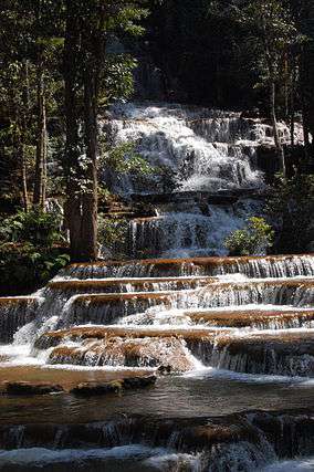
- Namtok Pha Charoen A limestone waterfall receiving water from a creek that flows into a pool of water. This ninety-seven-tiered waterfall flows year round.
- Bo Nam Ron Huai Nam Nak The water in this natural hot well measures 12 degrees Celsius. There are gazebos provided by the Phop Phra District administration next to the well at its side on the Ro Pho Cho Road.
- Doi Kia Viewpoint This is the highest point of the borderline between Myanmar and Thailand. It is around 512 m high and overlooks a forest in Myanmar.
- Namtok Pa Wai The waterfall originates from Pa Wai Creek where water flows all year round and many rattan plants grow.
- Namtok Sai Fa and Namtok Sai Rung These waterfalls have spray of water which looks like a rainbow when being seen in sunlight.
References
| Wikimedia Commons has media related to Namtok Pha Charoen National Park. |
- ↑ "Namtok Pha Charoen National Park". Department of National Parks (DNP) Thailand. Archived from the original on 3 March 2016. Retrieved 28 October 2015.
- ↑ "Pharcharoen National Park". Tourism Authority of Thailand (TAT). Retrieved 28 October 2015.