Nahalal
| Nahalal נַהֲלָל | |
|---|---|
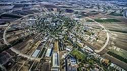 Aerial view of Nahalal | |
 Nahalal | |
| Coordinates: 32°41′24″N 35°11′48″E / 32.69000°N 35.19667°ECoordinates: 32°41′24″N 35°11′48″E / 32.69000°N 35.19667°E | |
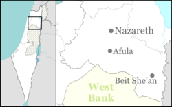
| District | Northern |
| Council | Jezreel Valley |
| Affiliation | Moshavim Movement |
| Founded | 1921 |
| Founded by | Jews from Eastern Europe |
| Population (2017)[1] | 845 |


Nahalal (Hebrew: נַהֲלָל) is a moshav in northern Israel. Covering 8.5 square kilometers, it falls under the jurisdiction of Jezreel Valley Regional Council. In 2017 it had a population of 845.[1]
Nahalal is best known for its general layout, as designed by Richard Kauffmann: slightly oval round, similar to a spoke wheel with its public buildings at the "hub" and individual plots of agricultural land radiating from it like spokes with symmetrically placed roads creating eight equal sectors, an inner ring of residential buildings, and an outer ring road.[2]
In the Hebrew Bible
Nahalal was a Levitical city mentioned in the Hebrew Bible. It was located in the territory of the tribe of Zebulun (Joshua 19:15) and given to the Merarite division of the Levite tribe. In the King James Version of the Bible it is called Nahallal.[3] It has also been referred to as Nahalol.[4]
History
Antiquity
Archaeological findings in the area suggest human settlement there dates to the Bronze Age, and continued into the Iron Age, Persian era, Hellenistic period, Roman era, and Byzantine era. Among the artifacts found was an ancient Jewish inscription of the word "Sabbath" on a rock, from Nahalal or nearby Shimron.[5]
Ottoman empire
An Arab village in the area, Ma'alul, was incorporated into the Ottoman Empire in 1517. It was identified with the biblical Nahalal by Rabbi Joseph Schwartz in 1850.
Modern era
By the 20th century, Ma'alul's inhabitants were tenants of the Sursuq family of Beirut, absentee landlords who had acquired the land earlier. In 1921, they sold all but 2,000 dunams of Ma'alul's land to the Zionist Palestine Land Development Company.[6] Moshe Dayan mentioned Nahalal as an example of "there is not one place built in this country which did not have a former Arab population".[7]
Nahalal was founded on 11 September 1921, on land given to the founders by the Jewish National Fund. It was the first moshav ovidim (workers' cooperative agricultural settlement) in Mandatory Palestine.[8] The modern moshav was designed by Richard Kauffmann. Its founders immigrated to Palestine from Eastern Europe as part of the Second Aliyah and Third Aliyah between 1904 and 1914 (at the end of the Ottoman rule), some of whom had been members of the first kibbutz, Degania Alef. After working in farming communities for a decade, they dreamt of establishing an income-sharing farming community similar to a kibbutz, but they wanted to maintain the nuclear household structure (kibbutzim had communal dining and children slept in separate housing).
The rivulets created marshes that attracted Anopheles mosquitoes that spread malaria. Heeding the warnings of the experts among them, like Dr. Hillel Yaffe, an expert on the war against malaria, they temporarily settled on a nearby hill, near the Arab village of Ma'lul. Later, the founders came down from the hill and divided the land.
According to a census conducted in 1922 by the British Mandate authorities, Nahalal had a population of 437 Jews.[9]
On 22 December 1932, a member of Nahalal and his son were killed when a bomb was thrown into their home.
The physical layout of Nahalal, devised by architect Richard Kaufmann, became the pattern for many moshavim established before 1948; it is based on concentric circles, with the public buildings (school, administrative and offices, services, and warehouses) in the center, the homesteads in the innermost circle, the farm buildings in the next, and beyond those, ever-widening circles of gardens and fields, initially divided into 80 equal parcels, 75 to the members and 5 to Kaduri agricultural school (the first two parts and the last three parts contain the agricultural school). This equal parceling of the land became the trademark geometric shape of Nahalal.
Education
In 1929, a Girls' Agricultural Training Farm was established at Nahalal by Hana Meisel of the Women's International Zionist Organization, and in the 1940s it became a co-educational farming school of the Youth Aliyah movement.
Notable residents
- Assi Dayan (1945–2014), film director, actor, screenwriter, and producer; son of Moshe Dayan
- Moshe Dayan, Minister of Defense
- Ruth Dayan (née Schwartz), social activist; first wife of Moshe Dayan
- Shmuel Dayan, activist and politician; father of Moshe Dayan
- Yael Dayan, MK and daughter of Moshe Dayan
- Yehonatan Geffen, musician, nephew of Moshe Dayan
- Amos Hadar, Member of the Knesset
- Aryeh Nehemkin, Minister of Agriculture
- Amir Pnueli (1941–2009), computer scientist
- Nissan Rilov (1922–2007), painter
- Meir Shalev, writer,
- Hannah Szenes, paramilitary and poet
- Pnina Gary (born 11927), actress and theatre director
Note:
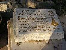
- Ilan Ramon, Israel's first astronaut, is buried in the Nahalal cemetery, though he never lived in Nahalal.
References
- 1 2 "List of localities, in Alphabetical order" (PDF). Israel Central Bureau of Statistics. Retrieved August 26, 2018.
- ↑ Richard KauffmannDie Bebauungsplaene der Kleinsiedlungen Kfar-Nahalal und Kfar-Jecheskiel ('The construction plans for the agricultural small housing estates Kfar Nahalal and Kfar Jecheskiel'), published by the Department for Agricultural Colonization of the Zionist Executive, Jerusalem (1923), in German.
- ↑ King James Version, Joshua 19:15
- ↑ Revised Version, Judges 1:30
- ↑ Mordechai Aviam (2011). "The Sabbath Boundary at Timrat". In Eretz Magazine. A Hebrew version of the article is also available.
- ↑ a total of 16,000 dunams, with 90 families, according to List of villages sold by Sursocks and their partners to the Zionists since British occupation of Palestine, evidence to the Shaw Commission, 1930
- ↑ Rogan, Eugene L.; Shlaim, Avi (2001). The War for Palestine: Rewriting the History of 1948. Cambridge University Press. p. 207. ISBN 0-521-79476-5.
- ↑ Bernard Reich and David H. Goldberg (2008). Historical Dictionary of Israel (2 ed.). Scarecrow Press. p. 329.
- ↑
External links
| Wikimedia Commons has media related to Nahalal. |
- Official website
- Degania & Nahalal UNESCO
- Nahalal Jewish Agency for Israel
- LIFE Magazin, Jul 5, 1937, "Jews made a garden" - aerial photo of Nahalal (page 55), and a girl from Girls' Agricultural Training Farm (page 54), at Google Books.
- 25 Mind-Blowing Aerial Photographs Around the World at twistedsifter.com – better aerial photograph at #9, by Yann Arthus-Bertrand.