Degania Alef
| Degania Alef | |
|---|---|
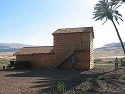
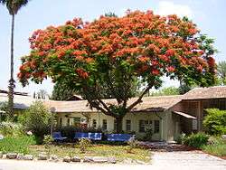 Buildings (1912 or after) of Degania | |
 Degania Alef | |
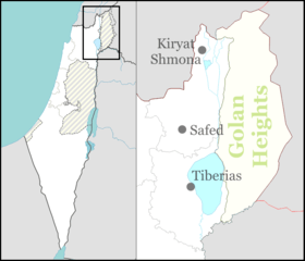
| Coordinates: 32°42′29″N 35°34′29″E / 32.70806°N 35.57472°ECoordinates: 32°42′29″N 35°34′29″E / 32.70806°N 35.57472°E | |
| District | Northern |
| Council | Emek HaYarden |
| Affiliation | Kibbutz Movement |
| Founded | 1910, after first beginnings in 1909 |
| Founded by | Jewish pioneers |
| Population (2017)[1] | 752 |
| Website | www.degania.org.il |
Degania Alef (Hebrew: דְּגַנְיָה א', D'ganya Alef) is a kibbutz in northern Israel. It falls under the jurisdiction of the Emek HaYarden Regional Council. Degania was smaller than a kibbutz. It was established in 1909 by immigrants to Ottoman Palestine.[2] Degania Alef and its neighbour Degania Bet both lie between the southern shore of the Sea of Galilee and the Jordan River. In 2017 it had a population of 752.[1]
Etymology
Degania means "cornflower"[3] and is derived from dagan, meaning "grain".[4] After the first phase at Umm Junieh, the group and its settlement was simply called Degania, Alef being added only after the establishment of the associated kibbutzim of Degania Bet and Gimel in 1920. Alef, Bet and Gimel are the first letters of the Hebrew alphabet and carry the numerical values 1, 2 and 3.
History
Roman period
According to the 1881 Survey of Western Palestine, Umm Junieh was possibly the place called Union, or Homonœa, by Josephus (Vita, 54).[5][6]
Ottoman period
Umm Junieh
The Muslim village called Umm Junieh[7] is mentioned during the Late Ottoman period (late 19th century) at the site from which the first Jewish settlers would start establishing their community in 1909-1910. A map from Napoleon's invasion of 1799 by Pierre Jacotin showed the place as ruined.[8] Umm Junieh was just by the ancient bridge Jisr es Sidd, which was also marked as ruined by Jacotin.[8]
In 1875, Victor Guérin observed the village of Oumm Djouneh, sitting on a hill east of the river Jordan.[9] In 1881, the Palestine Exploration Fund's Survey of Western Palestine (SWP) described the place, (then named Umm Junieh), as a stone and adobe village, on the east side of the river Jordan, on the top of the eastern bank of the river. It contained about 250 Muslim inhabitants. All the plain around was arable soil; no trees. A mill was worked at the village.[10] A population list from about 1887 showed that Umm Juny had about 330 inhabitants, all Muslim.[11]
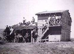
Beginnings of Degania
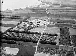
Degania (later Degania Alef) was the first kvutza established by Zionist pioneers of the Yishuv under Ottoman rule. The location was south-west of the Sea of Galilee within the administrative Ottoman area of Acre Sanjak. It was founded by a group of ten men and two women at a place known in Arabic as Umm Junieh or Umm Juni. Degania Bet was established to the south of it in 1920.[12]
In June 1912, the group moved from the mud huts and wooden shack of Umm Juni to the new stone-built compound at its permanent location.[13] That is at the place where the Jordan River emerges from the Sea of Galilee and therefore had the Arabic name Bab al-Tumm, "Gate of the Mouth".[13][14]
The poetess Rachel Bluwstein, the "prophet of labor" A. D. Gordon, and paramilitary commander and leading Zionist Joseph Trumpeldor all worked at Degania Alef. Zionist pioneer and future Israeli politician Yosef Baratz was among the founders of Degania Alef. On June 5, 1912, he married and started the first family. His first child, Gideon Baratz (1913-1988), who was born in Degania Alef,[15] was the first child born in a Jewish collective community in Palestine.[16] The second child to be born in Degania Alef was the prominent Israeli general and politician Moshe Dayan. Dayan was named after Moshe Barsky, a member of Degania Alef who was the first kibbutz member killed in an Arab attack.[17] Barsky was killed in November 1913. He was alone in the kibbutz fields when he was shot in the back and left for dead by Arab marauders.[18]
British Mandate
By 1947 Degania Alef had a population of 380.
Israeli period
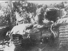
On May 20, 1948, during the Battles of the Kinarot Valley, in one of the first battles of the 1948 Arab–Israeli War, the residents of Degania Alef and Bet, assisted by a small number of military personnel, repelled a Syrian attack and succeeded in halting the advance of the Syrian army into the Jordan Valley.[12] During the attack Degania Alef was completely destroyed by the Syrian army.[19] According to a 1949 book by the Jewish National Fund, the village was destroyed following attacks on the neighboring kibbutzim of Sha'ar HaGolan and Masada. The settlers resisted, however, and launched a counter-attack which helped to recover the neighboring settlements. Reconstruction started almost immediately.[4]
Economy
In 2007, Degania Alef moved to undergo privatisation.[20] Instead of assigned jobs and equal pay under the former communal economy, the reorganisation requires members to find employment, live on their income, and allows them to own their homes, but still offers a form of a social "safety net" supplement for members whose livelihood is inadequate to meet their expenses. This move to privatisation was chronicled in Yitzhak Rubin's 2008 documentary, Degania: The First Kibbutz Fights Its Last Battle.
Awards and recognition
In 1981, Kvutza Degania Alef was awarded the Israel Prize, for its special contribution to society and the State in social pioneering.[21]
Notable members and residents
- Rachel Bluwstein (1890–1931), national poet
- Moshe Dayan (1915–1981), military man and politician; second child born here
- A. D. Gordon (1856–1922), Zionist ideologist (the "prophet of labor") and pioneer
- Joseph Trumpeldor (1880–1920), Zionist leader, army officer
- Yosef Baratz (1890–1968), one of the founders; Zionist activist and Israeli politician
References
- 1 2 "List of localities, in Alphabetical order" (PDF). Israel Central Bureau of Statistics. Retrieved August 26, 2018.
- ↑ Adult children of the dream The Jerusalem Post, 6 May 2010
- ↑ Degania Jewish Agency
- 1 2 Jewish National Fund (1949). Jewish Villages in Israel. Jerusalem: Hamadpis Liphshitz Press. p. 31.
- ↑ Conder and Kitchener, 1881, SWP I, p. 371
- ↑ Josephus, Vita, see paragraph 54
- ↑ Place-name derived from personal name, according to Palmer, 1881, p. 136
- 1 2 Karmon, 1960, p. 167.
- ↑ Guérin, 1880, p. 283
- ↑ Conder and Kitchener, 1881, SWP I, p. 362
- ↑ Schumacher, 1888, p. 187
- 1 2 Yuval El'azari, ed. (2005). Mapa's concise gazetteer of Israel (in Hebrew). Tel-Aviv: Mapa Publishing. p. 125. ISBN 965-7184-34-7.
- 1 2 Degania Alef website: History
- ↑ Henry Stewardson, The Survey of Western Palestine: A General Index..., An Index of the Arabic and English Name Lists, p. 82. Palestine Exploration Fund, 1888
- ↑
- ↑ Brilliant, Moshe: Portrait of Israel (1970)
- ↑ Taslitt, Israel Isaac (1969). Soldier of Israel: the story of General Moshe Dayan. Tel Aviv: Funk and Wagnalls. p. 8.
- ↑ La Guardia, Anton (2002). War without end: Israelis, Palestinians, and the struggle for a promised land. Tel Aviv: Macmillan. p. 113.
- ↑ Martin Van Creveld (2002). The sword and the olive: a critical history of the Israeli defense force. PublicAffairs. pp. 79, 82, 180. ISBN 1-58648-155-X.
- ↑ Tim McGirk (2 May 2007). "Postcard:Galilee". Time Magazine.
- ↑ "Israel Prize Official Site - Recipients in 1981 (in Hebrew)".
Bibliography
- Conder, C.R.; Kitchener, H.H. (1882). The Survey of Western Palestine: Memoirs of the Topography, Orography, Hydrography, and Archaeology. 2. London: Committee of the Palestine Exploration Fund.
- Department of Statistics (1945). Village Statistics, April, 1945. Government of Palestine.
- Guérin, V. (1880). Description Géographique Historique et Archéologique de la Palestine (in French). 3: Galilee, pt. 1. Paris: L'Imprimerie Nationale.
- Karmon, Y. (1960). "An Analysis of Jacotin's Map of Palestine" (PDF). Israel Exploration Journal. 10 (3, 4): 155–173, 244–253.
- Mills, E., ed. (1932). Census of Palestine 1931. Population of Villages, Towns and Administrative Areas. Jerusalem: Government of Palestine.
- Palmer, E.H. (1881). The Survey of Western Palestine: Arabic and English Name Lists Collected During the Survey by Lieutenants Conder and Kitchener, R. E. Transliterated and Explained by E.H. Palmer. Committee of the Palestine Exploration Fund.
- Schumacher, G. (1888). "Population list of the Liwa of Akka". Quarterly statement - Palestine Exploration Fund. 20: 169–191.
Further reading
- Gavron, Daniel (2000). The Kibbutz: Awakening from Utopia. Lanham, MD: Rowman & Littlefield.
External links
| Wikimedia Commons has media related to Degania Alef. |
- Official website (in English)
- Official website (in Hebrew)
- A Day in Degania, from the Steven Spielberg Jewish Film Archive internet site