Kogarah City Council
| Kogarah City Council New South Wales | |||||||||||||||
|---|---|---|---|---|---|---|---|---|---|---|---|---|---|---|---|
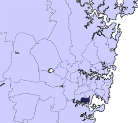 Location in Metropolitan Sydney, 1887–2016 | |||||||||||||||
| Coordinates | 33°58′S 151°08′E / 33.967°S 151.133°ECoordinates: 33°58′S 151°08′E / 33.967°S 151.133°E | ||||||||||||||
| Population | 55,806 (2011)[1] | ||||||||||||||
| • Density | 2,860.4/km2 (7,408/sq mi) | ||||||||||||||
| Established | 22 December 1885 | ||||||||||||||
| Abolished | 12 May 2016 | ||||||||||||||
| Area | 19.51 km2 (7.5 sq mi)a | ||||||||||||||
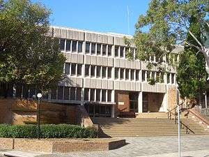
| Council seat | Civic Centre, Kogarah | ||||||||||||||
| Region | St George | ||||||||||||||
|
| |||||||||||||||
| Website | Kogarah City Council | ||||||||||||||
| |||||||||||||||
The Kogarah City Council was a local government area in the St George region of southern Sydney, in the state of New South Wales, Australia. The centre of the city is located 14 kilometres (8.7 mi) south-west of the Sydney central business district and west of Botany Bay.
The Municipality of Kogarah was established on 22 December 1885 and in 2008 Kogarah became the first local government area in New South Wales to become a city by popular vote, known as the "Kogarah City Council". The city was bounded by the Illawarra railway line, Georges River, Rocky Point Road, Princes Highway and Harrow Road. The name Kogarah is Aboriginal, meaning place of reeds and takes its name from the reeds that grew in the inlets along the Georges River and at the head of Kogarah Bay.[2]
A 2015 review of local government boundaries by the NSW Government Independent Pricing and Regulatory Tribunal recommended that the Kogarah City Council merge with the Hurstville City Council to form a new council with an area of 38 square kilometres (15 sq mi) and support a population of approximately 147,000.[3] On 12 May 2016, the NSW Government announced that the Kogarah City Council would merge with the Hurstville City Council to form the Georges River Council with immediate effect.[4]
Council history
The "Municipal District of Kogarah" was proclaimed on 23 December 1885 and the District’s boundaries commenced at the intersection of the Illawarra Railway Line with the northern shore of George’s River. The Municipal District was re-named the "Municipality of Kogarah" following the passage of the Municipalities Act, 1897 on 6 December 1897.[5] On 22 December 1916 and 1 January 1969, parts of Rockdale Municipality were transferred to Kogarah.[5] In 1993, following the passing of the new Local Government Act, the Municipality of Kogarah became known as "Kogarah Council". Kogarah Council was proclaimed a city in 2008.
In December 1920, Kogarah combined with the councils of Rockdale, Hurstville, and Bexley to form the St George County Council. The elected County Council was established to provide electricity to the Kogarah, Rockdale, Hurstville, and Bexley areas and ceased to exist when it was amalgamated with the Sydney County Council on 1 January 1980.[6]
Suburbs and localities in the former local government area
Suburbs in the Kogarah City Council were:
- Allawah (parts are located within City of Rockdale council)
- Beverley Park
- Blakehurst
- Carlton (parts are located within City of Rockdale council)
- Carss Park
- Connells Point
- Hurstville (parts were located within Hurstville City Council)
- Hurstville Grove
- Kogarah (parts are located within City of Rockdale council)
- Kogarah Bay
- Kyle Bay
- Mortdale
- Oatley
- Penshurst (parts were located within Hurstville City Council)
- Sans Souci
- South Hurstville
Kogarah City Council also managed and maintained the following localities:
- Bald Face
- Carss Point
- Connells Bay
- Harness Cask Point
- Neverfail Bay
- Oatley Bay
- Shipwright Bay
- Tom Uglys Point
Demographics
At the 2011 Census, there were 55,806 people in the Kogarah local government area, of these 48.8% were male and 51.2% were female. Aboriginal and Torres Strait Islander people made up 0.4% of the population. The median age of people in the Kogarah City Council was 37 years. Children aged 0 – 14 years made up 17.6% of the population and people aged 65 years and over made up 14.1% of the population. Of people in the area aged 15 years and over, 54.5% were married and 8.8% were either divorced or separated.[1]
Population growth in the Kogarah City Council between the 2001 Census and the 2006 Census was 5.32%; and in the subsequent five years to the 2011 Census, population growth was 6.22%. When compared with total population growth of Australia for the same periods, being 5.78% and 8.32% respectively, population growth in Kogarah local government area was marginally lower than the national average.[7] The median weekly income for residents within the Kogarah City Council was generally on par with the national average.[1][8]
| Selected historical census data for Kogarah local government area | |||||
|---|---|---|---|---|---|
| Census year | 2001[7] | 2006[8] | 2011[1] | ||
| Population | Estimated residents on Census night | 49,885 | 52,537 | 55,806 | |
| LGA rank in terms of size within New South Wales | |||||
| % of New South Wales population | 0.81% | ||||
| % of Australian population | 0.27% | ||||
| Cultural and language diversity | |||||
| Ancestry, top responses | Chinese | 18.7% | |||
| Australian | 14.4% | ||||
| English | 14.1% | ||||
| Greek | 8.7% | ||||
| Irish | 5.1% | ||||
| Language, top responses (other than English) | Mandarin | 4.0% | |||
| Cantonese | 7.0% | ||||
| Greek | 8.0% | ||||
| Arabic | 3.6% | ||||
| Macedonian | n/c | ||||
| Religious affiliation | |||||
| Religious affiliation, top responses | Catholic | 27.8% | |||
| No religion | 12.1% | ||||
| Eastern Orthodox | 13.3% | ||||
| Anglican | 17.4% | ||||
| Buddhism | n/c | ||||
| Median weekly incomes | |||||
| Personal income | Median weekly personal income | A$514 | A$605 | ||
| % of Australian median income | 110.3% | 104.9% | |||
| Family income | Median weekly family income | A$1,164 | A$1,667 | ||
| % of Australian median income | 113.3% | 112.6% | |||
| Household income | Median weekly household income | A$1,354 | A$1,463 | ||
| % of Australian median income | 115.6% | 118.6% | |||
Council
Composition and election method
Kogarah City Council was composed of twelve Councillors elected proportionally as four separate wards, each electing three Councillors. All Councillors were elected for a fixed four-year term of office. The Mayor was elected by the Councillors at the first meeting of the Council. The last election was held on 8 September 2012, and the final makeup of the council for the term 2012–2016, in order of election by ward, was as follows:[9][10][11][12]
| Ward | Councillor | Party | Notes | |
|---|---|---|---|---|
| East Ward[9] | Sam Stratikopoulos | Liberal | Councillor 2012–2016 | |
| Michael Platt | Labor | Deputy Mayor 1996–1997, 2012–2013, Mayor 2004–2005, 2014–2015 | ||
| Annie Tang | Unity | Deputy Mayor 2005–2006, 2008–2011, 2013–2016 | ||
| Middle Ward[10] | Nickolas Varvaris | Liberal | Deputy Mayor 2004–2005, 2006–2007, Mayor 2005–2006, 2008–2013 | |
| Nathaniel Smith | Liberal | Councillor 2012–2016 | ||
| Kathryn Landsberry | Labor | Deputy Mayor 2007–2008 | ||
| North Ward[11] | Lachlan McLean | Independent | Councillor 2008–2016 | |
| Stephen Agius | Liberal | Mayor 2013–2014, 2015–2016 | ||
| Nick Katris | Labor | Mayor 2007–2008 | ||
| West Ward[12] | Nicholas Aroney | Liberal | Councillor 2012–2016 | |
| George Katsabaris | Liberal | Councillor 2012–2016 | ||
| Jacinta Petroni | Labor | Deputy Mayor 2011–2012 | ||
Footnotes
^a Land component is 15.55 square kilometres (6.00 sq mi)
References
- 1 2 3 4 Australian Bureau of Statistics (31 October 2012). "Kogarah (C)". 2011 Census QuickStats. Retrieved 4 November 2012.

- ↑ "Kogarah Residents' Guide: History" (PDF). Kogarah City Council. 2012. Retrieved 4 November 2012.
- ↑ "Merger proposal: Hurstville City Council, Kogarah City Council" (PDF). Government of New South Wales. January 2016. p. 7. Retrieved 28 February 2016.
- ↑ Trembath, Murray (12 May 2016). "John Rayner leads new Georges River Council". St George & Sutherland Shire Leader. Retrieved 15 May 2016.
- 1 2 "3802 Kogarah Council". State Records Archives Investigator. State Archives and Records Authority of New South Wales. Retrieved 25 September 2017.
- ↑ "3489 St George County Council". State Records Archives Investigator. State Archives and Records Authority of New South Wales. Retrieved 25 September 2017.
- 1 2 Australian Bureau of Statistics (9 March 2006). "Kogarah (C)". 2001 Census QuickStats. Retrieved 3 November 2012.
- 1 2 Australian Bureau of Statistics (25 October 2007). "Kogarah (C)". 2006 Census QuickStats. Retrieved 3 November 2012.
- 1 2 "Kogarah City Council - East Ward". Local Government Elections 2012. Electoral Commission of New South Wales. 14 September 2012. Retrieved 17 September 2012.
- 1 2 "Kogarah City Council - Middle Ward". Local Government Elections 2012. Electoral Commission of New South Wales. 14 September 2012. Retrieved 17 September 2012.
- 1 2 "Kogarah City Council - North Ward". Local Government Elections 2012. Electoral Commission of New South Wales. 14 September 2012. Retrieved 17 September 2012.
- 1 2 "Kogarah City Council - West Ward". Local Government Elections 2012. Electoral Commission of New South Wales. 14 September 2012. Retrieved 17 September 2012.