Carlton, New South Wales
| Carlton Sydney, New South Wales | |||||||||||||||
|---|---|---|---|---|---|---|---|---|---|---|---|---|---|---|---|
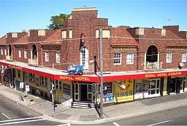 Royal Hotel, Railway Parade | |||||||||||||||
| Population | 10,722 (2016 census)[1] | ||||||||||||||
| Established | 1886 | ||||||||||||||
| Postcode(s) | 2218 | ||||||||||||||
| Location | 15 km (9 mi) south of Sydney CBD | ||||||||||||||
| LGA(s) | |||||||||||||||
| State electorate(s) | Rockdale | ||||||||||||||
| Federal Division(s) | |||||||||||||||
| |||||||||||||||

Carlton is a suburb in southern Sydney, in the state of New South Wales, Australia. Carlton is located 15 kilometres south of the Sydney central business district and is part of the St George area. Carlton lies across the boundary of two local government areas, the Georges River Council and the Bayside Council.
History
The area was originally heavily timbered. Carlton was part of a grant of 1,950 acres (7.9 km2) made to Captain John Townson in 1808. The grant extended from King Georges Road and Stoney Creek Road to beyond Kogarah railway station. When the railway line to Hurstville was opened in 1884, large estates were subdivided and residents began moving in. However, there was no platform at Carlton until 1889. Landholders were given a block of land free if they contributed 400 pounds to finance the construction of the platform and station buildings. They were also guaranteed a first class ticket to Sydney for one year.[2]
Commercial area and transport
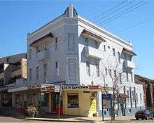
Carlton’s main shopping centre is located on both sides of Carlton railway station, on Railway Parade and Carlton Parade. Commercial developments are also found along the Princes Highway. Carlton railway station is on the Illawarra line of the Sydney Trains network. Limited bus services also run throughout Carlton, such as those provided by Transdev NSW.
Parks and recreation
Parks located in Carlton are Jubilee Oval, Kogarah Park, Tinsdale Reserve, Anglo Square Park & Agusta Park. Carlton is home to the St George Illawarra Dragons National Rugby League team. The St George home ground is located on Jubilee Avenue, and is known as WIN Jubilee Oval (formerly Jubilee Oval and OKI Jubilee Stadium). The Walk of Fame featuring St George legends is located in Park Street. The St George Leagues Club is located nearby on Princes Highway.
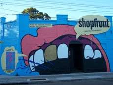
The Shopfront Contemporary Arts Centre in Carlton Parade is a co-operative owned completely by young people aged 8 to 25 with an international reputation that has made Australian and overseas tours. It was founded by Errol Bray in 1976.
Population
Demographics
According to the 2011 census of Population,were 9,808 residents in Carlton. 52.9% stated they were born overseas with the top countries of birth being China 11.5%, Macedonia 3.7% and Greece 3.1%. English was stated as the only language spoken at home by 36.7% residents the most common other languages spoken were Mandarin 9.3%, Greek 8.3% and Cantonese 8.3%. The most common responses for religious affiliation were Catholic 21.1%, No Religion 18.3% and Orthodox 18.1%.[1]
Schools and churches
Carlton has two schools: Carlton Public School and Carlton South Public School.
- St Bernadette's Catholic Church, Carlton Uniting Church, Carlton Baptist Church, Carlton Presbyterian Church, St Cuthbert's Anglican Church
- St Cuthbert's Anglican Church is on the corner of Park Road and Colvin Avenue.[3]
References
- 1 2 Australian Bureau of Statistics (27 June 2017). "Carlton (NSW) (State Suburb)". 2016 Census QuickStats. Retrieved 11 April 2018.

- ↑ The Book of Sydney Suburbs, Compiled by Frances Pollon, Angus & Robertson Publishers, 1990, Published in Australia ISBN 0-207-14495-8, page 52
- ↑ http://www.southcarlton.anglican.asn.au/Index.html%5Bpermanent+dead+link%5D
| Wikimedia Commons has media related to Carlton, New South Wales. |
Coordinates: 33°58′16″S 151°07′28″E / 33.97117°S 151.12439°E