Mundrabilla Land District
| Mundrabilla Western Australia | |||||||||||||||
|---|---|---|---|---|---|---|---|---|---|---|---|---|---|---|---|
 | |||||||||||||||
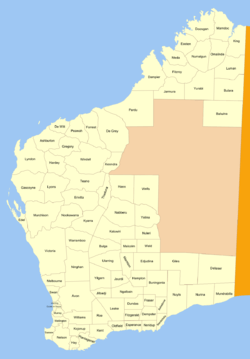
Mundrabilla Land District is a land district (cadastral division) of Western Australia, located within the Eucla Land Division on the Nullarbor Plain. It spans roughly 31°00'S - 32°00'S in latitude and 127°30'E - 129°00'E in longitude.
Location and features
The district is located on the Nullarbor Plain on the Western Australia–South Australia border, and falls generally between the Great Australian Bight to the south and the Trans-Australian Railway to the north. The town of Eucla on the Eyre Highway and the railway town of Forrest are located within its boundaries.[1]
History
The district was created on 4 March 1903.[2] When the Trans-Australian Railway was being built in 1914, the district was adjusted such that the railway formed its northern boundary. It was hence defined in the Government Gazette:[3]
| “ | Bounded on the North by the centre of the Trans-Australian Railway Line; on the East by the East boundary of the State; on the West by a North line from Red Rock Point through Survey Mark E11; and on the South by the sea coast. | ” |
References
- ↑ "Index Map of Western Australia", Department of Lands and Surveys, 1949.
- ↑ "New Land Districts (per 7835/97)". Western Australia Government Gazette. 4 March 1903. p. 1903:613.
- ↑ "The Land Act, 1898. Amendment of Boundaries of Nurina, Mundrabilla and Nuyts Districts. (per 7835/97)". Western Australia Government Gazette. 10 July 1914. p. 1914:2559.
Coordinates: 31°30′S 128°15′E / 31.500°S 128.250°E