Mu'minobod District
| Mu'minobod District Ноҳияи Мӯъминобод | |
|---|---|
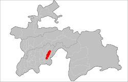 | |
 Mu'minobod District Mu'minobod District Location in Tajikistan | |
| Coordinates: 38°06′32.3″N 70°01′37.9″E / 38.108972°N 70.027194°ECoordinates: 38°06′32.3″N 70°01′37.9″E / 38.108972°N 70.027194°E | |
| Country |
|
| Province | Khatlon |
| Capital | Mu'minobod |
| Area | |
| • Land | 2,387 km2 (922 sq mi) |
| Population (2010) | |
| • Total | 72 300 |
| • Ethnicities |
|
| • Languages | Tajik-Persian |
| Time zone | UTC+5 |
| • Summer (DST) | UTC+5 |
| Website | tj |
Mu'minobod District or Nohiya-i Mu'minobod (Tajik: Ноҳияи Мӯъминобод) is a district in Khatlon province, Tajikistan. Its capital is Mu'minobod, in Soviet times, from 1973 − 1997, known as Leningradskiy.
Administrative divisions
The district is divided administratively into jamoats. They are as follows (and population).[1]
| Jamoats of Mu'minobod District [2] | |
| Jamoat | Population |
|---|---|
| Balhobi | 8315 |
| Bogai | 7961 |
| Childukhtaron | |
| Dehbaland | 11470 |
| Kulchashma | 17086 |
| Leningrad | 11131 |
| Tutu | 7279 |
Geography
This district is situated in the mountainous southeastern part of Khatlon, Kulob Region, and is bordering Afghanistan. The district spans 2,387 square kilometers, and consists of seven jamoats.[3]
History
The district was established in 1973 within Kulob.[4]
References
- ↑ "List of Jamoats". UN Coordination, Tajikistan. Archived from the original on July 16, 2011. Retrieved April 4, 2009.
- ↑ http://www.undp.tj/files/maps/JCP/Tajik_pdf/Local_Governance/Khatlon/LG4.3.pdf
- ↑ Historical Dictionary of Tajikistan, Dushanbe, 2010, p. 245
- ↑ Historical Dictionary of Tajikistan, Dushanbe, 2010, p. 245
| Capital | 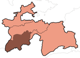 | |
|---|---|---|
| Districts | ||
| Main cities and towns | ||
This article is issued from
Wikipedia.
The text is licensed under Creative Commons - Attribution - Sharealike.
Additional terms may apply for the media files.