Farkhor District
| Farkhor District (Tajik: Ноҳияи Фархор) | |
|---|---|
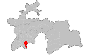 Farkhor District in the map of Tajikistan. | |
 Farkhor District Farkhor Location in Tajikistan | |
| Coordinates: 37°30′0″N 69°24′0″E / 37.50000°N 69.40000°ECoordinates: 37°30′0″N 69°24′0″E / 37.50000°N 69.40000°E | |
| Country |
|
| Province | Khatlon |
| Capital | Farkhor |
| Area | |
| • Land | 1,138,1 km2 (4,394 sq mi) |
| Population (2008) | |
| • Total | 95 040 |
| • Ethnicities |
|
| • Languages | Tajik |
| Time zone | UTC+5 |
| +992 3316 | 735140 |
| Website | tj |
Farkhor District (Tajik: Ноҳияи Фархор) is a district in Khatlon province, Tajikistan. Its capital is Farkhor.
Administrative divisions
The district is divided administratively into jamoats. They are as follows (and population).[1]
| Jamoats of Farkhor District | |
| Jamoat | Population |
|---|---|
| Darqad | 9270 |
| Dehqonariq | 9076 |
| Farkhor | 19338 |
| Galaba | |
| Ghayrat | 11920 |
| Gulshan | 9066 |
| Komsomolobod | 10358 |
| Vatan | 16749 |
| Zafar | 9263 |
References
- ↑ "List of Jamoats". UN Coordination, Tajikistan. Archived from the original on July 16, 2011. Retrieved April 4, 2009.
| Capital | 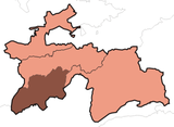 | |
|---|---|---|
| Districts | ||
| Main cities and towns | ||
This article is issued from
Wikipedia.
The text is licensed under Creative Commons - Attribution - Sharealike.
Additional terms may apply for the media files.