Mount Vision Fire
| Mount Vision Fire | |
|---|---|
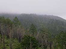 Burned trees from the Mount Vision Fire at Point Reyes | |
| Location | Point Reyes, Inverness, California |
| Coordinates | 38°04′59″N 122°52′59″W / 38.083°N 122.883°WCoordinates: 38°04′59″N 122°52′59″W / 38.083°N 122.883°W |
| Statistics[1] | |
| Cost | $6.2 million ($10 million today) |
| Date(s) | October 3, 1995 – October 16, 1995 |
| Burned area | 12,354 acres (50 km2) |
| Cause | Illegal campfire |
| Buildings destroyed | 45 |
| Map | |
 Location of fire in California  Mount Vision Fire (California) | |
The Mount Vision Fire was a wildfire that burned 12,354 acres (50 km2) of land on the Point Reyes National Seashore peninsula in northern California during October 1995. The fire, which was started by an incompletely extinguished campfire, destroyed 45 homes in Inverness Park.[1]
References
- 1 2 "Vision Fire 10 Year Anniversary Fact Sheet #3 – Incident Statistics" (PDF). National Park Service. Retrieved September 8, 2015.
| Pre-2000 |
|
|---|---|
| 2002 | |
| 2003 | |
| 2004 | |
| 2005 | |
| 2006 | |
| 2007 | |
| 2008 | |
| 2009 | |
| 2010 | |
| 2011 | |
| 2012 | |
| 2013 | |
| 2014 | |
| 2015 | |
| 2016 | |
| 2017 | |
| 2018 | |
| |
This article is issued from
Wikipedia.
The text is licensed under Creative Commons - Attribution - Sharealike.
Additional terms may apply for the media files.