Mount Emmons (New York)
| Mount Emmons | |
|---|---|
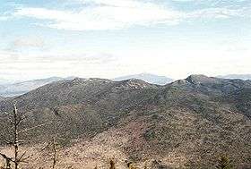 Mount Emmons (left) seen from Seymour Mountain, March 1995 | |
| Highest point | |
| Elevation | 4,039 ft (1,231 m) [1] |
| Prominence | 102 ft (31 m) [1] |
| Listing | Adirondack High Peaks |
| Coordinates | 44°08′37″N 74°12′51″W / 44.1436698°N 74.2140464°WCoordinates: 44°08′37″N 74°12′51″W / 44.1436698°N 74.2140464°W [2] |
| Naming | |
| Etymology | Ebenezer Emmons |
| Geography | |
 Mount Emmons Location of Mount Emmons within New York | |
| Location |
Franklin County, New York United States |
| Parent range |
Seward Mountains, Adirondack Mountains |
| Topo map | USGS Ampersand Lake |
Mount Emmons is a mountain located in the Adirondack Mountains near the southern edge of Franklin County, New York, United States.
Description
The mountain is located within the High Peaks Wilderness Area of Adirondack Park. The mountain (elevation 4,022 feet [1,226 m])[2][1] is part of the Seward Mountains of the Adirondacks. Mount Emmons is flanked to the north by Donaldson Mountain and is the westernmost of the 46 High Peaks.
The summit is named after Ebenezer Emmons[3] (1799–1863), a geologist who named the Adirondack Mountains and led the first recorded ascent of Mount Marcy in 1837.
Mount Emmons stands within the watershed of the Cold River, which drains into the Raquette River, the Saint Lawrence River in Canada, and into the Gulf of Saint Lawrence. The east side of Mt. Emmons drains into Seward Brook, thence into the Cold River. The west side of Emmons drains into Boulder Brook, thence into the Cold River.
See also
References
- 1 2 3 "Mount Emmons, New York". Peakbagger.com. Retrieved 30 Jan 2013.
- 1 2 U.S. Geological Survey Geographic Names Information System: Mount Emmons
- ↑ Gannett, Henry (1905). The Origin of Certain Place Names in the United States. Govt. Print. Off. p. 119.
External links
- "Mount Emmons". SummitPost.org.