Mount Ascutney
| Mount Ascutney | |
|---|---|
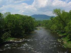 Mount Ascutney from Claremont, New Hampshire | |
| Highest point | |
| Elevation | 3,144 ft (958 m) [1] |
| Prominence | 2,270 ft (690 m) [1] |
| Listing | #25 on New England Fifty Finest |
| Coordinates | 43°26′40″N 72°27′13″W / 43.4445164°N 72.4537019°WCoordinates: 43°26′40″N 72°27′13″W / 43.4445164°N 72.4537019°W [2] |
| Geography | |
 Mount Ascutney | |
| Topo map | USGS Mount Ascutney |
| Climbing | |
| Easiest route | Hike |
| Mt. Ascutney State Park | |
|---|---|
 Mount Ascutney State Park, August 2012 | |
| Type | State park |
| Location |
1826 Back Mountain Road Windsor, Vermont |
| Area | About 2,000 acres |
| Operated by | Vermont Department of Forests, Parks, and Recreation |
| Open | Mid May - Mid October |
| Website | https://vtstateparks.com/ascutney.html |
Mount Ascutney is a monadnock located in southern Vermont. With a summit elevation of about 3144 feet (958 m.), it is the second-highest peak in Windsor County, Vermont (the highest is Gillespie Peak to the west). Particularly noteworthy about Ascutney are its granite outcrops, one of which, near its peak, serves as a launching point for hang-gliders. The mountain is very steep, and its trails traverse a Vermont state forest.
While the name "Ascutney" was originally thought to come from the Abenaki word Ascutegnik, which was the name of a settlement near where the Sugar River meets the Connecticut River, it was later determined that the name actually has no meaning. [3] The Abenaki name for the mountain is Kaskadenak (pronounced: Cas-Cad-Nac), which means "mountain of the rocky summit" or "wide mountain".[4][3] In July 2018, the State of Vermont Board of Libraries, which has the state's mountain naming authority, heard arguments to officially rename the mountain to Mount Kaskadenak. The renaming had strong support from the indigenous tribes. The Board voted 5-0 to reject the name change citing local opposition from residents.[5]
The mountain's base straddles several villages — Ascutney, Brownsville, Windsor, and West Windsor — and it is located only several miles off exit 8 on Interstate 91. The mountain itself is visible from the top of Mount Washington, seventy miles away.
Location and description
Mt. Ascutney is located in the southeastern section of Windsor County, in the Connecticut River Valley. The village of Ascutney, in the town of Weathersfield, is to the south. To the north lie the towns of Windsor and West Windsor. The village of Brownsville, in the town of West Windsor, sits at the northwestern base of the mountain. To the east lies the Connecticut River and the city of Claremont, New Hampshire. To the immediate west stands another, smaller mountain, fittingly named Little Ascutney Mountain.
Viewing the mountain
Vermont Route 131 follows the south face of the mountain, and provides some good views of Ascutney. Similarly, Vermont Routes 44 and 44-A follow the north face, and provide a number of views of that side of the mountain. The north-south route of Interstate 91 runs just east of the mountain and provides extensive views of both the north and south faces. New Hampshire Routes 12 and 12-A provide good views of the east face. Viewing of the west face is difficult, due to the presence, immediately to the west, of Little Ascutney Mountain.
At longer distance, the mountain is visible from many locations quite a few miles away, particularly hilltops and other mountains. Ascutney can be viewed from select locations on the Dartmouth College campus, among them the upper floors of Rauner Library and the Steele Chemistry Building.
Cornish Colony
From the late 1880s to 1930, a community of artists thrived in Cornish and Plainfield, New Hampshire as well as Windsor, Vermont. Besides Augustus Saint-Gaudens, other artists built their homes specifically sited towards the mountain, and it became the focal point of many expansive gardens and Italianate villas.[6] Maxfield Parrish, Charles Platt, Thomas Dewing, and Winston Churchill (the writer) all built homes to view the mountain. Many of these houses remain, view intact, and the estate Augustus Saint Gaudens is now a national park, with, of course, a lovely view.
Geology
Mount Ascutney is part of the White Mountain plutonic-volcanic series of igneous rocks. These rocks intruded from Triassic to Cretaceous time in southern Maine, New Hampshire, and Vermont with the relatively young Ascutney pluton intruding at ~122 MA (K/Ar date on Biotite). The Ascutney pluton is about 8 km × 4 km in map area and intrudes Precambrian basement gneisses of the Chester dome and overlying Paleozoic metasedimentary rocks. The pluton emplacement is probably related to the formation of transform faults and/or fracture zones during (failed) Mesozoic rifting.[7][8] The petrology of the pluton consists of three stocks which are gabbro-diorite, syenite and granite. There is also a partial ring dike and number of other dikes in the area.[9]
The last glacier broke material off the mountain and distributed it southward into Massachusetts. The trail it left is known as the "Mount Ascutney Train."[10]
Hang gliding
Mount Ascutney is the premier hang gliding site in New England. Notable for its excellent soaring, it is not unusual for hang gliders to fly from Mt. Ascutney to nearby states. Some trips can stretch to the New Hampshire or Massachusetts coastline, a flight of over 90 miles. The record cross country flight from Mt. Ascutney is held by Curt Warren who flew 131.6 mi (211.8 km) into Connecticut on August 7, 2002.
Bronson Farm
Actor Charles Bronson owned a farm near the mountain he and his wife named Zuleika, after their daughter. His remains were buried at Brownsville Cemetery in West Windsor, near the foot of the mountain, after his 2003 death.
Wildlife
Wild turkeys, deer, porcupines, and a wide variety of birds are commonly seen on Mt. Ascutney. The mountain is a favorite area for viewing migrating birds, which use the Connecticut River as a navigation pathway. More rarely seen wildlife includes moose, black bears, bobcats and fishers.
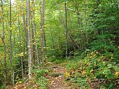
Hiking trails
The mountain features four principal hiking trails, three of which are named for the town from which that trail originates:
- The Weathersfield Trail — The one trail on the south face of the mountain, the base of this trail is located in a parking lot at the end of Cascade Falls Rd, off of Vermont Route 131 in Weathersfield. Highlights of this trail include Cascade Falls, the largest waterfall on the mountain, and the mountain's one launch platform for hang gliders.
- The Windsor Trail — This trail originates from a small parking area off Vermont Route 44-A just east of the junction with Vermont Route 44. About 1/3 of the way up, the trail comes to a small waterfall, approximately 2/3 of the way up the trail comes to a small log lean-to shelter. Near the top, it merges with the Brownsville Trail.
- The Brownsville Trail — This trail begins at a parking area along Vermont Route 44, a little over a mile west of junction with Vermont Route 44-A. The lower end of the trail follows an abandoned logging road for some distance — the road terminating at the location of an old granite quarry. The trail offers many good viewing opportunities to the north and west.
- The Futures Trail — This trail begins in the campground at Mt. Ascutney State Park on Route 44A, one mile west of the junction with U.S. Route 5 in Ascutney. This is the longest trail on Mt. Ascutney — 4.6 miles, covering a wide variety of forest and geography before it connects to the Windsor Trail near the summit. Highlights of this trail include Bare Rock Vista (1.0 mile) and the Steam Donkey — a steam powered machine used for cable logging in the early 1900s (3.5 miles). This trail can also be accessed at two points along the State Park Mountain Road for a shorter hike to summit.
At the top, a relatively level trail follows the ridgeline and crosses the summit. The top of the mountain is well below the tree line and is therefore covered in forest. There are a number of rocky cliffs allow good viewing, one lookout in particular The Nowlan Lookout is named for a local American sculptor Lawrence Nowlan. There is an observation tower, as well. There are also two large communications towers.
The summit can also be reached via a short trail from the parking lot at the end of the only road up the mountain, the Mt. Ascutney State Park Mountain Road.
Skiing and the Ascutney Mountain Resort
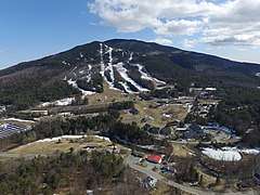
Mt. Ascutney was home to the Ascutney Mountain Resort, which was a ski resort located on the mountain's northwest face, in the village of Brownsville.[11] Opening after the end of World War II, skiing facilities originally consisted of just one rope tow. Prior to its most recent closure in the fall of 2010, the resort boasted several chairlifts, including one high-speed detachable quad, as well as a hotel, condominiums and a large base lodge. The resort's trails accommodated the entire family, but expert and intermediate skiers found themselves most at home at the resort, whose trails averaged from medium grade to steep, and were often icy from the mountain's often harsh winds. The ski resort's primary competitors were Killington, Okemo, Mount Sunapee, and Stratton.
Mount Ascutney State Park
Mount Ascutney State Park, a campground run by the state of Vermont, provides non-primitive RV or tent camping during the summer months. The park entrance is located along Vermont Route 44-A near Windsor. The road into the park, which is also the one road up the mountain, begins climbing almost immediately. The road continues to climb, rising over 2000 feet in less than 4 miles, eventually arriving at a parking lot about a 1/2 mile walk from the summit. The park is listed in the National Register of Historic Places.
See also
References
- 1 2 "Mount Ascutney, Vermont". Peakbagger.com. Retrieved 2013-01-30.
- ↑ "Mount Ascutney". Geographic Names Information System. United States Geological Survey. Retrieved 2010-12-04.
- 1 2 "State board to consider changing mountain's made-up name". AP News. Retrieved 2018-07-13.
- ↑ Bob Lindemann (2003). Dave Hardy, ed. 50 Hikes In Vermont: Walks, Hikes, and Overnights in the Green Mountain State. The Green Mountain Club. p. 74. ISBN 9780881505382.
- ↑ "Vermont board rejects mountain name change proposal". WJHL. 2018-07-17. Retrieved 2018-07-23.
- ↑ Carlisle, Julia. "Cornish, New Hampshire Cornish Colony Artistic and Agricultural". Snyder Donegan Real Estate Group. Retrieved 2016-04-17.
- ↑ Ballard, R.D. and Uchupi, E. (1975) Triassic rift structure in the Gulf of Maine. American Association of Petroleum Geologists Bulletin 59, 7, 1041-1072
- ↑ Foland, K.A. and Faul, H. (1977) Ages of the White Mountain intrusives-New Hampshire, Vermont and Maine, USA. American Journal of Sciences, 277 888-904.
- ↑ Schneiderman, J S. (1991) Petrolog and mineral chemistry of the Ascutney Mountain igneous complex. American Mineralogist, Vol 76 p 218-229
- ↑ Charles W Johnson. The nature of Vermont (eBook). Google. p. 20. ISBN 9780585224497.
- ↑ Jonathan Robinson. "The History of Skiing on Mt. Ascutney". Archived from the original on 2010-07-18.
External links
| Wikimedia Commons has media related to Ascutney State Park. |