Camels Hump State Forest
| Camels Hump State Forest | |
|---|---|
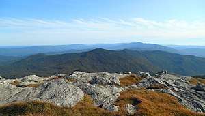 From Camel's Hump Summit looking south toward Mt. Ethan Allen. | |
| Type | State forest |
| Location | Chittenden and Washington Counties, Vermont |
| Coordinates | 44°10′04″N 72°50′57″W / 44.16775°N 72.8492°WCoordinates: 44°10′04″N 72°50′57″W / 44.16775°N 72.8492°W |
| Area | 2,323 acres (9.40 km2) in two blocks |
| Created | 1986 |
| Operated by | Vermont Department of Forests, Parks, and Recreation |
| Website | Website |
Camels Hump State Forest covers a total of 2,323 acres (9.40 km2) in two blocks in Vermont. Steven's Block comprises 1,680 acres (6.8 km2) in Fayston, Buels Gore and Starksboro in Chittenden and Washington Counties. It is managed for wildlife habitat and timber resources, and the Long Trail runs through this area.[1] Howe Block is 643 acres (2.60 km2) in Fayston, and Waitsfield in Chittenden and Washington counties and is popular for mountain biking.[2] The forest is managed by the Vermont Department of Forests, Parks, and Recreation.
References
- ↑ "Camels Hump State Forest". Vermont Dept. of Forests, Parks and Recreation. Retrieved 4 February 2017.
- ↑ "Camel's Hump State Forest: Howe Block Mountain Bike Trails". Trail Finder. Retrieved 5 February 2017.
External links
This article is issued from
Wikipedia.
The text is licensed under Creative Commons - Attribution - Sharealike.
Additional terms may apply for the media files.