Motteggiana
| Motteggiana Munticìana, Moteciàna (Emilian) | |
|---|---|
| Comune | |
| Comune di Motteggiana | |
 Motteggiana Location of Motteggiana in Italy | |
| Coordinates: 45°2′N 10°46′E / 45.033°N 10.767°ECoordinates: 45°2′N 10°46′E / 45.033°N 10.767°E | |
| Country | Italy |
| Region | Lombardy |
| Province | Province of Mantua (MN) |
| Frazioni | Torricella, Villa Saviola |
| Area | |
| • Total | 24.6 km2 (9.5 sq mi) |
| Highest elevation | 26 m (85 ft) |
| Lowest elevation | 16 m (52 ft) |
| Population (Dec. 2014) | |
| • Total | 2,629 |
| • Density | 110/km2 (280/sq mi) |
| Demonym(s) | Motteggianesi |
| Time zone | UTC+1 (CET) |
| • Summer (DST) | UTC+2 (CEST) |
| Postal code | 46020 |
| Dialing code | 0376 |
| Website | Official website |
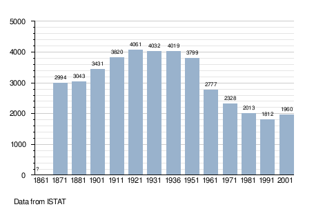
Motteggiana (Lower Mantovano: Munticìana or Moteciàna) is a comune (municipality) in the Province of Mantua in the Italian region Lombardy, located about 130 kilometres (81 mi) southeast of Milan and about 15 kilometres (9 mi) south of Mantua. As of 31 December 2004, it had a population of 2,629 and an area of 24.6 square kilometres (9.5 sq mi).[1]
The municipality of Motteggiana contains the frazioni (subdivisions, mainly villages and hamlets) Torricella and Villa Saviola.
Motteggiana borders the following municipalities: Borgo Virgilio, Pegognaga, San Benedetto Po, Suzzara, Viadana.
Demographic evolution
Twin towns
Motteggiana is twinned with:
References
- ↑ All demographics and other statistics: Istituto Nazionale di Statistica (Istat).
External links
- www.comune.motteggiana.mn.it/
- http://lombardia.indettaglio.it/eng/comuni/mn/motteggiana/motteggiana.html

This article is issued from
Wikipedia.
The text is licensed under Creative Commons - Attribution - Sharealike.
Additional terms may apply for the media files.