Morganville, Kansas
| Morganville, Kansas | |
|---|---|
| City | |
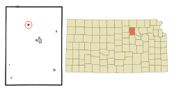 Location within Clay County and Kansas | |
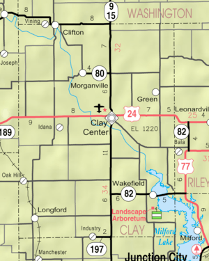 KDOT map of Clay County (legend) | |
| Coordinates: 39°28′2″N 97°12′12″W / 39.46722°N 97.20333°WCoordinates: 39°28′2″N 97°12′12″W / 39.46722°N 97.20333°W | |
| Country | United States |
| State | Kansas |
| County | Clay |
| Area[1] | |
| • Total | 0.34 sq mi (0.88 km2) |
| • Land | 0.34 sq mi (0.88 km2) |
| • Water | 0 sq mi (0 km2) |
| Elevation | 1,234 ft (376 m) |
| Population (2010)[2] | |
| • Total | 192 |
| • Estimate (2016)[3] | 189 |
| • Density | 560/sq mi (220/km2) |
| Time zone | UTC-6 (CST) |
| • Summer (DST) | UTC-5 (CDT) |
| ZIP code | 67468 |
| Area code | 785 |
| FIPS code | 20-48225 [4] |
| GNIS ID | 0476020 [5] |
Morganville is a city in Clay County, Kansas, United States. As of the 2010 census, the city population was 192.[6]
History
Morganville was founded in 1870.[7] It was named for its founder, Ebenezer Morgan.[8] The first store in Morganville opened in 1871.[9]
The post office in Morganville was originally called Della. It was established in 1871.[10]
Morganville was located on the Chicago, Rock Island and Pacific Railroad.[11]
Geography
Morganville is located at 39°28′2″N 97°12′12″W / 39.46722°N 97.20333°W (39.467189, -97.203350).[12] According to the United States Census Bureau, the city has a total area of 0.34 square miles (0.88 km2), all of it land.[1]
Demographics
| Historical population | |||
|---|---|---|---|
| Census | Pop. | %± | |
| 1890 | 233 | — | |
| 1900 | 350 | 50.2% | |
| 1910 | 285 | −18.6% | |
| 1920 | 262 | −8.1% | |
| 1930 | 281 | 7.3% | |
| 1940 | 264 | −6.0% | |
| 1950 | 278 | 5.3% | |
| 1960 | 226 | −18.7% | |
| 1970 | 257 | 13.7% | |
| 1980 | 261 | 1.6% | |
| 1990 | 181 | −30.7% | |
| 2000 | 198 | 9.4% | |
| 2010 | 192 | −3.0% | |
| Est. 2016 | 189 | [3] | −1.6% |
| U.S. Decennial Census | |||
2010 census
As of the census[2] of 2010, there were 192 people, 79 households, and 55 families residing in the city. The population density was 564.7 inhabitants per square mile (218.0/km2). There were 86 housing units at an average density of 252.9 per square mile (97.6/km2). The racial makeup of the city was 97.4% White, 1.0% African American, 0.5% from other races, and 1.0% from two or more races. Hispanic or Latino of any race were 2.6% of the population.
There were 79 households of which 29.1% had children under the age of 18 living with them, 58.2% were married couples living together, 7.6% had a female householder with no husband present, 3.8% had a male householder with no wife present, and 30.4% were non-families. 26.6% of all households were made up of individuals and 16.5% had someone living alone who was 65 years of age or older. The average household size was 2.43 and the average family size was 2.89.
The median age in the city was 43.5 years. 23.4% of residents were under the age of 18; 7.9% were between the ages of 18 and 24; 22.5% were from 25 to 44; 28.6% were from 45 to 64; and 17.7% were 65 years of age or older. The gender makeup of the city was 53.1% male and 46.9% female.
2000 census
As of the census[4] of 2000, there were 198 people, 77 households, and 54 families residing in the city. The population density was 581.0 people per square mile (224.8/km²). There were 88 housing units at an average density of 258.2 per square mile (99.9/km²). The racial makeup of the city was 96.46% White, 0.51% Native American, 1.01% from other races, and 2.02% from two or more races. Hispanic or Latino of any race were 1.01% of the population.
There were 77 households out of which 31.2% had children under the age of 18 living with them, 61.0% were married couples living together, 3.9% had a female householder with no husband present, and 28.6% were non-families. 26.0% of all households were made up of individuals and 11.7% had someone living alone who was 65 years of age or older. The average household size was 2.57 and the average family size was 3.11.
In the city, the population was spread out with 30.8% under the age of 18, 3.5% from 18 to 24, 22.7% from 25 to 44, 23.7% from 45 to 64, and 19.2% who were 65 years of age or older. The median age was 40 years. For every 100 females, there were 104.1 males. For every 100 females age 18 and over, there were 101.5 males.
The median income for a household in the city was $33,125, and the median income for a family was $36,429. Males had a median income of $24,688 versus $21,563 for females. The per capita income for the city was $12,423. About 2.3% of families and 4.4% of the population were below the poverty line, including 7.7% of those under the age of eighteen and none of those sixty five or over.
Education
Morganville is a part of USD 379 Clay County School District.[13]
Morganville schools were closed through school unification. The Morganville High School mascot was Morganville Eagles.[14]
References
- 1 2 "US Gazetteer files 2010". United States Census Bureau. Archived from the original on 2012-01-24. Retrieved 2012-07-06.
- 1 2 "American FactFinder". United States Census Bureau. Retrieved 2012-07-06.
- 1 2 "Population and Housing Unit Estimates". Retrieved June 9, 2017.
- 1 2 "American FactFinder". United States Census Bureau. Retrieved 2008-01-31.
- ↑ "US Board on Geographic Names". United States Geological Survey. 2007-10-25. Retrieved 2008-01-31.
- ↑ "2010 City Population and Housing Occupancy Status". U.S. Census Bureau. Retrieved August 4, 2011.
- ↑ Kansas State Historical Society (1916). Biennial Report of the Board of Directors of the Kansas State Historical Society. Kansas State Printing Plant. p. 161.
- ↑ Heim, Michael (2007). Exploring Kansas Highways. p. 80.
- ↑ Blackmar, Frank Wilson (1912). Kansas: A Cyclopedia of State History, Volume 2. Standard Publishing Company. p. 312.
- ↑ "Kansas Post Offices, 1828-1961 (archived)". Kansas Historical Society. Archived from the original on October 9, 2013. Retrieved 7 June 2014.
- ↑ "Geohydrology of Clay County". Kansas Geological Survey. Retrieved 2 August 2014.
- ↑ "US Gazetteer files: 2010, 2000, and 1990". United States Census Bureau. 2011-02-12. Retrieved 2011-04-23.
- ↑ "Clay County USD 379". USD 379. Retrieved 4 January 2017.
- ↑ "Five Lettermen At Morganville", The Salina Journal, 24 November 1957, p.18.
External links
| Wikimedia Commons has media related to Morganville, Kansas. |
- City
- Schools
- USD 379, local school district
- Maps
- Morganville City Map, KDOT
Municipalities and communities of Clay County, Kansas, United States | ||
|---|---|---|
| Cities | 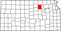 | |
| Unincorporated communities | ||
| Ghost towns | ||
| Townships | ||
| Footnotes | ‡This populated place also has portions in an adjacent county or counties | |