Broughton, Kansas
| Broughton, Kansas | |
|---|---|
| Ghost town | |
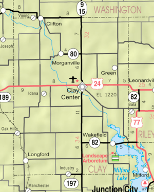 KDOT map of Clay County (legend) | |
 Broughton  Broughton | |
| Coordinates: 39°19′17″N 97°3′12″W / 39.32139°N 97.05333°WCoordinates: 39°19′17″N 97°3′12″W / 39.32139°N 97.05333°W[1] | |
| Country | United States |
| State | Kansas |
| County | Clay |
| Founded | 1869 |
| Elevation[1] | 1,184 ft (361 m) |
| Population | |
| • Total | 0 |
| Time zone | UTC-6 (CST) |
| • Summer (DST) | UTC-5 (CDT) |
| Area code | 785 |
| FIPS code | 20-08625 [1] |
| GNIS ID | 476188 [1] |
Broughton is a ghost town in Clay County, Kansas, United States.[1] It was located a few miles southeast of Clay Center.
History
Broughton was founded in 1869. It was razed in 1966 during the construction of Milford Lake. The communities of Alida and Broughton were razed, while the cities of Wakefield and Milford were moved to higher ground.
References
Further reading
- Broughton Kansas: Portrait of a Lost Town 1869-1966; M.J. Morgan; Chapman Center for Rural Studies at KSU; 2010; ISBN 978-0979778841.
External links
- A short film about Broughton, Kansas, a Lost Town, YouTube
- The Vanished Community of Broughton, Kansas, KSU
- Photos of Broughton, Lost Kansas Communities
- 1907 photo of Broughton, WSU Library
- Clay County Maps: Current, Historic, KDOT
Municipalities and communities of Clay County, Kansas, United States | ||
|---|---|---|
| Cities | 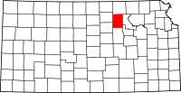 | |
| Unincorporated communities | ||
| Ghost towns | ||
| Townships | ||
| Footnotes | ‡This populated place also has portions in an adjacent county or counties | |
This article is issued from
Wikipedia.
The text is licensed under Creative Commons - Attribution - Sharealike.
Additional terms may apply for the media files.