Idana, Kansas
| Idana, Kansas | |
|---|---|
| Unincorporated community | |
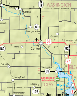 KDOT map of Clay County (legend) | |
| Coordinates: 39°21′33.3″N 97°15′54.0″W / 39.359250°N 97.265000°WCoordinates: 39°21′33.3″N 97°15′54.0″W / 39.359250°N 97.265000°W | |
| Country | United States |
| States | Kansas |
| County | Clay |
| Time zone | UTC-6 (CST) |
| • Summer (DST) | UTC-5 (CDT) |
| ZIP code | 67432 |
| GNIS feature ID | 476474 [1] |


Idana is an unincorporated community in Clay County, Kansas, United States. It is located near the town of Clay Center, south of US Route 24.[2]
History
Idana is combination of the names of two settlers: Ida Howland and Anna Broughton.[3]
A post office was opened in Chapmanville (an extinct town) in 1879, but it was moved to Idana in 1882 and remained in operation until it was discontinued in 1980.[4]
Idana was located on the Union Pacific Railroad.[5]
References
- ↑ "Idana". Geographic Names Information System. United States Geological Survey.
- ↑ http://kansas.hometownlocator.com/ks/clay/idana.cfm
- ↑ "Profile for Idana, Kansas". ePodunk. Retrieved 7 June 2014.
- ↑ "Kansas Post Offices, 1828-1961 (archived)". Kansas Historical Society. Archived from the original on October 9, 2013. Retrieved June 7, 2014.
- ↑ "Geohydrology of Clay County". Kansas Geological Survey. Retrieved 2 August 2014.
External links
Municipalities and communities of Clay County, Kansas, United States | ||
|---|---|---|
| Cities | 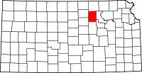 | |
| Unincorporated communities | ||
| Ghost towns | ||
| Townships | ||
| Footnotes | ‡This populated place also has portions in an adjacent county or counties | |
This article is issued from
Wikipedia.
The text is licensed under Creative Commons - Attribution - Sharealike.
Additional terms may apply for the media files.