Morafenobe District
| Morafenobe District | |
|---|---|
| District | |
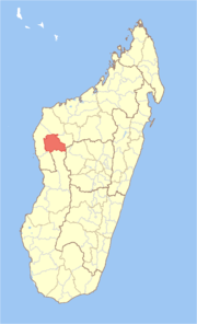 Location in Madagascar | |
| Coordinates: 16°9′S 46°37′E / 16.150°S 46.617°E | |
| Country |
|
| Region | Melaky |
| Area[1] | |
| • Total | 6,976 km2 (2,693 sq mi) |
| Population (2001) | |
| • Total | 20,475 |
| • Density | 2.9/km2 (8/sq mi) |
| • Ethnicities | Sakalava |
| Time zone | UTC3 (EAT) |
Morafenobe is a district in western Madagascar. It is a part of Melaky Region and borders the districts of Besalampy in north, Ambatomainty in east, Miandrivazo in south, Antsalova in southwest and Maintirano in west. The area is 6,976 km2 (2,693 sq mi) and the population was estimated to be 20,475 in 2001.[1]
The district is further divided into three communes:
References and notes
- 1 2 "Madagascar Administrative units". GeoHive. Retrieved 2008-03-04.
Coordinates: 16°9′S 46°37′E / 16.150°S 46.617°E
| Antsalova |  | |
|---|---|---|
| Ambatomainty |
| |
| Besalampy | ||
| Maintirano | ||
| Morafenobe | ||
This article is issued from
Wikipedia.
The text is licensed under Creative Commons - Attribution - Sharealike.
Additional terms may apply for the media files.