Morafenobe
| Morafenobe | |
|---|---|
 Morafenobe Location in Madagascar | |
| Coordinates: 17°49′S 44°55′E / 17.817°S 44.917°E | |
| Country |
|
| Region | Melaky |
| District | Morafenobe |
| Elevation[1] | 210 m (690 ft) |
| Time zone | UTC3 (EAT) |
Morafenobe is a town and commune (Malagasy: kaominina) in western Madagascar. It belongs to the district of Morafenobe, which is a part of Melaky Region.[2]
Morafenobe is served by a local airport. Primary and junior level secondary education are available in town. The town provides access to hospital services to its citizens.[2]
Geography
This town is located at the Manambaho river between Maintirano and Beravina.[3]
References and notes
- ↑ Estimated based on DEM data from Shuttle Radar Topography Mission
- 1 2 "ILO census data". Cornell University. 2002. Retrieved 2008-03-04.
- ↑ Atlas Mondial, France Loisir, page 158
| Antsalova | 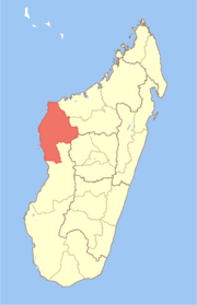 | |
|---|---|---|
| Ambatomainty |
| |
| Besalampy | ||
| Maintirano | ||
| Morafenobe | ||
Coordinates: 17°49′S 44°55′E / 17.817°S 44.917°E
This article is issued from
Wikipedia.
The text is licensed under Creative Commons - Attribution - Sharealike.
Additional terms may apply for the media files.