Besalampy District
| Besalampy District | |
|---|---|
| District | |
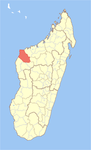 Location in Madagascar | |
| Coordinates: 16°9′S 46°37′E / 16.150°S 46.617°E | |
| Country |
|
| Region | Melaky |
| Area[1] | |
| • Total | 11,753 km2 (4,538 sq mi) |
| Population (2001) | |
| • Total | 37,782 |
| • Density | 3.2/km2 (8/sq mi) |
| • Ethnicities | Sakalava |
| Time zone | UTC3 (EAT) |
Besalampy is a district in western Madagascar. It is a part of Melaky Region and borders the districts of Soalala in northeast, Kandreho in east, Ambatomainty in southeast, Morafenobe in south and Maintirano in southwest. The area is 11,753 km2 (4,538 sq mi) and the population was estimated to be 37,782 in 2001.[1]
The district is further divided into six communes.
Access
By road: from Antananarivo - Tsiroanomandidy -Besalampy by the route nationale n°1 [2]
References and notes
- 1 2 "Madagascar Administrative units". GeoHive. Retrieved 2008-03-04.
- ↑ Madagascar National Parks Archived May 11, 2012, at the Wayback Machine.
Coordinates: 16°9′S 46°37′E / 16.150°S 46.617°E
| Antsalova | 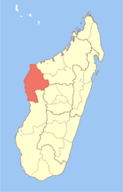 | |
|---|---|---|
| Ambatomainty |
| |
| Besalampy | ||
| Maintirano | ||
| Morafenobe | ||
This article is issued from
Wikipedia.
The text is licensed under Creative Commons - Attribution - Sharealike.
Additional terms may apply for the media files.