Antsalova District
| Antsalova District | |
|---|---|
| District | |
 Location in Madagascar | |
| Coordinates: 16°9′S 46°37′E / 16.150°S 46.617°E | |
| Country |
|
| Region | Melaky |
| Area | |
| • Total | 7,195 km2 (2,778 sq mi) |
| Population (2001) | |
| • Total | 30,062 |
| • Density | 4.2/km2 (11/sq mi) |
| • Ethnicities | Sakalava |
| Time zone | UTC3 (EAT) |
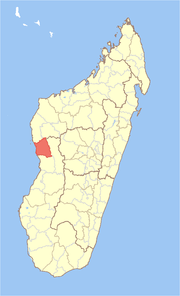
Antsalova is a district in western Madagascar. It is a part of Melaky Region and borders the districts of Maintirano in north, Morafenobe in northeast, Miandrivazo in east and Belon'i Tsiribihina in south. The area is 7,195 km2 (2,778 sq mi) and the population was estimated to be 30,062 in 2001.
The district is further divided into five communes:
References and notes
Coordinates: 16°9′S 46°37′E / 16.150°S 46.617°E
| Antsalova | 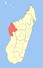 | |
|---|---|---|
| Ambatomainty |
| |
| Besalampy | ||
| Maintirano | ||
| Morafenobe | ||
This article is issued from
Wikipedia.
The text is licensed under Creative Commons - Attribution - Sharealike.
Additional terms may apply for the media files.