Montechiaro d'Asti
| Montechiaro d'Asti | ||
|---|---|---|
| Comune | ||
| Comune di Montechiaro d'Asti | ||
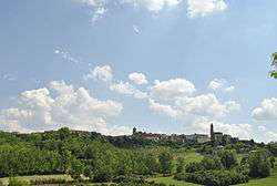 View of Montechiaro d'Asti | ||
| ||
 Montechiaro d'Asti Location of Montechiaro d'Asti in Italy | ||
| Coordinates: 45°0′N 8°7′E / 45.000°N 8.117°E | ||
| Country | Italy | |
| Region | Piedmont | |
| Province | Asti (AT) | |
| Frazioni | Nocciola, Regione Reale | |
| Government | ||
| • Mayor | Paolo Luzi | |
| Area | ||
| • Total | 10.14 km2 (3.92 sq mi) | |
| Elevation | 292 m (958 ft) | |
| Population (31 May 2007[1]) | ||
| • Total | 1,409 | |
| • Density | 140/km2 (360/sq mi) | |
| Demonym(s) | Montechiaresi | |
| Time zone | UTC+1 (CET) | |
| • Summer (DST) | UTC+2 (CEST) | |
| Postal code | 14025 | |
| Dialing code | 0141 | |
| Patron saint | St. Bernard of Clairvaux | |
| Saint day | August 20 | |
| Website | Official website | |
Montechiaro d'Asti (Piedmontese: Monciàir) is a town and comune (municipality) in the Province of Asti in the Italian region Piedmont, located about 35 kilometres (22 mi) east of Turin and about 13 kilometres (8 mi) northwest of Asti.
Montechiaro d'Asti borders the following municipalities: Camerano Casasco, Chiusano d'Asti, Cortanze, Cossombrato, Cunico, Montiglio Monferrato, Soglio, and Villa San Secondo.
Montechiaro is home to a notable example of Romanesque architecture in the Lower Montferrat, the church of St. Nazarius and Celsus (11th and 12th centuries).
Notable people
- Giovanni Pastrone, also known as Piero Fosco (1883–1959), pioneer of Italian film.
Twin towns

References
External links

This article is issued from
Wikipedia.
The text is licensed under Creative Commons - Attribution - Sharealike.
Additional terms may apply for the media files.