Monroe Township, Benton County, Iowa
| Monroe Township | |
|---|---|
| Township | |
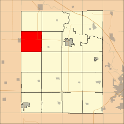 Location in Benton County | |
| Coordinates: 42°10′27″N 92°14′35″W / 42.17417°N 92.24306°WCoordinates: 42°10′27″N 92°14′35″W / 42.17417°N 92.24306°W | |
| Country |
|
| State |
|
| County | Benton |
| Area | |
| • Total | 94.04 km2 (36.31 sq mi) |
| • Land | 94.01 km2 (36.3 sq mi) |
| • Water | 0.03 km2 (0.01 sq mi) 0.03% |
| Elevation | 284 m (932 ft) |
| Population (2000) | |
| • Total | 259 |
| • Density | 2.8/km2 (7.1/sq mi) |
| Time zone | UTC-6 (CST) |
| • Summer (DST) | UTC-5 (CDT) |
| ZIP codes | 52224, 52229 |
| GNIS feature ID | 0468391 |
Monroe Township is one of twenty townships in Benton County, Iowa, USA. As of the 2000 census, its population was 259.[1]
History
Monroe Township was founded in 1851.[2]
Geography
According to the United States Census Bureau, Monroe Township covers an area of 36.31 square miles (94.04 square kilometers); of this, 36.3 square miles (94.01 square kilometers, 99.97 percent) is land and 0.01 square miles (0.03 square kilometers, 0.03 percent) is water.
Adjacent townships
- Bruce Township (north)
- Cedar Township (northeast)
- Jackson Township (east)
- Big Grove Township (southeast)
- Homer Township (south)
- Oneida Township, Tama County (southwest)
- Clark Township, Tama County (west)
- Geneseo Township, Tama County (northwest)
Cemeteries
The township contains these four cemeteries: Gnagy, Ramthun, Saint Joseph and Urmy.
Major highways
School districts
- Union Community School District
- Vinton-Shellsburg Community School District
Political districts
- Iowa's 3rd congressional district
- State House District 39
- State Senate District 20
References
- United States Census Bureau 2007 TIGER/Line Shapefiles
- United States Board on Geographic Names (GNIS)
- United States National Atlas
- ↑ United States Census Bureau American FactFinder
- ↑ The History of Benton County, Iowa, Containing a History of the County, Its Cities, Towns, &c. Western Historical. 1878. p. 312.
External links
| Wikimedia Commons has media related to Monroe Township, Benton County, Iowa. |
Municipalities and communities of Benton County, Iowa, United States | ||
|---|---|---|
| Cities | ||
| Townships | ||
| CDP | ||
| Unincorporated communities | ||
| Footnotes | ‡This populated place also has portions in an adjacent county or counties | |
This article is issued from
Wikipedia.
The text is licensed under Creative Commons - Attribution - Sharealike.
Additional terms may apply for the media files.