Pymmes Brook

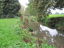

Pymmes Brook is located in North London and named after William Pymme, a local land owner. It is a minor tributary of the River Lea. The brook mostly flows through urban areas and is particularly prone to flooding in its lower reaches. To alleviate the problem the brook has been culverted in many areas. Part of it is a Site of Borough Importance for Nature Conservation, Grade II.[1][2]
Course
The brook rises in Hadley Wood, where it has the name Monken Mead Brook, and flows in a south-easterly direction to merge with the River Lee Navigation at Tottenham. It passes through East Barnet, where it is joined by a small tributary, the Shire Bourne, and then goes on to New Southgate, Arnos Grove, Palmers Green and Edmonton. After flowing through Pymmes Park the brook can be seen at Fore Street, Edmonton before it flows underground and emerges south of the North Circular Road at Angel Road, where it is joined by Salmons Brook. The brook then flows parallel with the River Lee Navigation in Tottenham Marshes until it merges with the Lea near Ferry Lane A503 and Tottenham Lock.
Parks
The brook can be seen in the following larger parks;
It also flows through a number of other open spaces, smaller parks, and greens.
Walking
The new, extended route of the Pymmes Brook Trail starts where the brook's headwaters rise on Hadley Green then follows its approximate course to its confluence with the River Lea at Tottenham Hale, where the trail joins the Lea Valley Walk.
History
The brook is marked thus on the Ordnance Survey map of 1877. In c.1200 it was called, Medeseye that is ' meadow marsh-stream ' from Old English mæd and sæge [3]
During the Middle Ages, it was known as the Medesenge, in the late 17th century as Millicents brook then, by the late 18th century as Bell brook.
See also
References
- ↑ "Pymme's Brook". Greenspace Information for Greater London. 2006. Retrieved 9 September 2012.
- ↑ "iGiGL – helping you find London's parks and wildlife sites". Greenspace Information for Greater London. 2006. Archived from the original on 15 October 2012.
- ↑ Mills . A. D. Oxford Dictionary of London Place Names (2001) p184 ISBN 0-19-860957-4
Further reading
External links
| Wikimedia Commons has media related to Pymme's Brook. |
Coordinates: 51°36′55″N 0°03′52″W / 51.6154°N 0.0645°W