East Barnet
| East Barnet | |
|---|---|
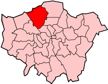
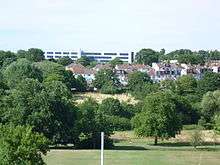
 East Barnet East Barnet shown within Greater London | |
| Population | 16,137 (2011 Census. Ward)[1] |
| OS grid reference | TQ271954 |
| London borough | |
| Ceremonial county | Greater London |
| Region | |
| Country | England |
| Sovereign state | United Kingdom |
| Post town | BARNET |
| Postcode district | EN4 |
| Dialling code | 020 |
| Police | Metropolitan |
| Fire | London |
| Ambulance | London |
| EU Parliament | London |
| UK Parliament | |
| London Assembly | |
East Barnet is an area of north London within the London Borough of Barnet bordered by New Barnet, Cockfosters and Southgate.[2][3] It is a largely residential suburb whose central area contains shops, public houses, restaurants and services, and the parish church of St Mary the Virgin. East Barnet is close to the M25 and the A1 and M1.
History
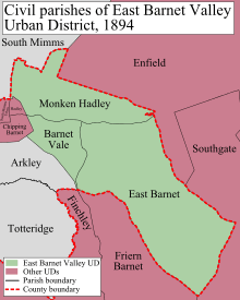
From 1894 until 1965 East Barnet formed part of the East Barnet Urban District of Hertfordshire. In 1965, it was transferred from Hertfordshire to Greater London; abolished; area amalgamated with Barnet and Friern Barnet Urban Districts, Finchley and Hendon Metropolitan Boroughs to form the London Borough of Barnet.
Governance
Barnet local elections are held every four years to elect councillors. East Barnet is covered by two wards:
- East Barnet Ward - East of the railway line and north of Parkside Gardens / Stuart Road.
- Brunswick Park Ward - East of the railway line and south of Parkside Gardens / Stuart Road.
Note: St Mary the Virgin – the Parish Church of East Barnet – is actually in Brunswick Park Ward.
Population
| 1881 | 3,992 |
|---|---|
| 1891 | 5,128 |
| 1901 | 6,839 |
| 1911 | 8,763 |
| 1921 | 9,747 |
| 1931 | 14,146 |
| 1941 | war # |
| 1951 | 31,672 |
| 1961 | 40,641 |
| # no census was held due to war | |
| source: UK census | |
Transport
- Buses
- 125 - Winchmore Hill (Station Road) to Finchley Central
- 184 - Barnet (Chesterfield Road) to Turnpike Lane bus/tube station
- 307 - Barnet (Barnet General Hospital) to Brimsdown railway station
- 326 - Barnet (the Spires) to Brent Cross Shopping Centre
- 382 - Southgate tube station to Mill Hill East tube station
- 383 - Barnet (the Spires) to Woodside Park tube station - Monday to Saturday except late evenings
- 384 - Barnet (Quinta Drive) to Cockfosters tube station
- Railway stations nearby
- Tube stations nearby
- Arnos Grove - Piccadilly line
- Cockfosters - Piccadilly line
- Oakwood - Piccadilly line
- High Barnet - Northern line
- Totteridge & Whetstone - Northern line
Education
- Primary schools
- Danegrove School (formerly Littlegrove Junior School and Oaklands Infant School)
- St. Mary's School
- Church Hill School
- Monkfrith School
- Secondary schools
Theatre and the Arts
Bodens Performing Arts School, aka Bodens, is located in East Barnet. It was founded in 1973 in Enfield, and has since moved to its current site. It is a performing arts school offering Arts education to children and teenagers from the ages of 3 to 18. The Studios are located on East Barnet Road, along with the 'Tony Boden Theatre' which is on premises.
Shops & Restaurants
- Costa Coffee
Geography
Neighbouring areas | |
|---|---|
References
- ↑ "Barnet Ward population 2011". Neighbourhood Statistics. Office for National Statistics. Retrieved 19 October 2016.
- ↑ Ordnance Survey: Landranger map sheet 166 Luton & Hertford (Hitchin & St Albans) (Map). Ordnance Survey. 2012. ISBN 9780319232095.
- ↑ "Ordnance Survey: 1:50,000 Scale Gazetteer" (csv (download)). www.ordnancesurvey.co.uk. Ordnance Survey. 1 January 2016. Retrieved 18 February 2016.
External links
| Wikimedia Commons has media related to East Barnet. |