Mokokchung district
| Mokokchung district | |
|---|---|
| District | |
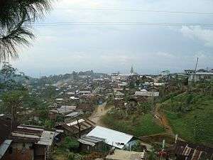 View of the district headquarters | |
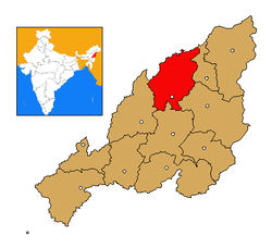 Mokokchung district's location in Nagaland | |
| Coordinates: 26°19′N 94°31′E / 26.317°N 94.517°ECoordinates: 26°19′N 94°31′E / 26.317°N 94.517°E | |
| Country | India |
| State | Nagaland |
| Seat | Mokokchung |
| Area[1] | |
| • Total | 1,615 km2 (624 sq mi) |
| Population (2011) | |
| • Total | 193,171 |
| • Density | 120/km2 (310/sq mi) |
| Time zone | UTC+05:30 (IST) |
| ISO 3166 code | IN-NL-MK |
| Website | http://mokokchung.nic.in/ |
Mokokchung (Pron:/ˌməʊkɒkˈtʃʌŋ/) is a district of Nagaland state in India. The town of Mokokchung is its headquarters. It is mainly occupied by the Ao Naga tribe who consider it their home.[2] It is bounded by the state of Assam to its north, Wokha district to its west, Tuensang and Longleng district to its east, and Zunheboto district to its south.
History
During the British Rule of India the Mokokchung area was part of the Naga Hills District of Assam. The Mokokchung subdivision of Naga Hills District was created in 1889, and it remained so following India independence in 1947. Naga Hills District remained as a district of Assam until 1957, when it and Tuensang Frontier Division of the North-East Frontier Agency (now Arunachal Pradesh) were joined to form the centrally governed Naga Hills Tuensang Area. At that point Mokokchung subdivision became a district, one of three alongside Kohima and Tuensang districts.
February 1961 saw the renaming of Naga Hills Tuensang Area to "Nagaland", and in December 1963 Nagaland became the 16th state of India. Finally December 1973 saw the new districts of Zunheboto and Wokha carved out of Mokokchung, leaving the borders of Mokokchung district as they stand today.[3]:8
Geography
It covers an area of 1,615 km².[1] The physiography of the district shows six distinct hill ranges. The ranges are approximately parallel to each other and are aligned roughly north-east/south-west. The district lies between 94.29 and 94.76 degrees east longitude and 26.20 and 26.77 degrees north latitude. The entire district of Mokokchung is conveniently sub-divided into ranges. The main valleys are Tsurang, Changki and Milak Valleys. The district is agriculturally and industrially among the most progressive districts in the state, along with Dimapur and Kohima. Major agricultural regions are Changki-Longnak, Tsurang, Milak and Dikhu valley regions. Tuli-Milak region and Changki-Longnak valley are the major industrial areas.
Major mountain ranges
- Ongpangkong
- Asetkong
- Jangpetkong
- Japukong
- Langpangkong
- Tsurangkong
Land use
| Category | Area (km2) |
|---|---|
| Total land | 1615 |
| Forest Department purchased land | 49.66 |
| Agriculture | 180.39 |
| Villages and towns | 10.50 |
| Horticulture | 8.12 |
| Different development departments | 386.07 |
| Degraded land | 982.62 |
Administration
Mokokchung district's administrative headquarters with its Indian Administrative Service (IAS) cadre is located at Mokokchung town. The Deputy Commissioner, also in Mokokchung town, is the head of the district.[3]:6
The district has four subdivisions, Mokokchung, Tuli, Mangkolemba and Changtongya,[4] and nine administrative/revenue circles - Ongpangkong, Tuli, Chuchuyimlang, Changtongya, Mangkolemba, Kubolong, Alongkima, Longchem and Merangmen.[5]
The sub-division of Mokokchung town is administered directly by the Deputy Commissioner and one Sub-Divisional Officer; Additional Deputy Commissioner (ADC) offices are located in the sub-divisions of Mangkolemba and Tuli administrative circles; a Sub-Divisional Officer is located in the sub-division of Changtongya circle, and Extra Assistant Commissioner EAC headquarters are located in the six remaining circles of Ongpangkong, Kubolong, Chuchuyimlang, Alongkima, Longchem and Merangmen.[6][4][3]:9[7]
There are six Rural Development Blocks (RDBs) in the district. Longchem and Kubolong circles each have their own RDB; whereas Alongkima, Mangkolemba and Merangmen constitute the Mangkolemba RDB; Tuli, Changtongya and Chuchuyimlang constitute the Changtongya RDB. The 19 villages of Ongpangkong are split between RDBs Ongpangkong North and Ongpangkong South.[3]:11
Assembly constituencies
Mokokchung elects ten members of the 60-seat Nagaland Legislative Assembly. The constituencies are Alongtaki, Jangpetkong, Impur, Angetyongpang, Koridang, Aonglenden, Mokokchung town, Mongoya, Tuli, Arkakong.[2] Presently four of its legislators are in the ruling DAN government while the other six belong to Congress, the main opposition party in the state.
Demographics
According to the 2011 census Mokokchung district has a population of 194,622. This gives it a ranking of 591st in India (out of a total of 640), Mokokchung has a sex ratio of 925 females for every 1000 males, and a literacy rate of 91.6%.[8]
Christianity is the predominant religion with 95% of its population being Baptist. The district was the first to embrace Christianity in the later part of the 19th century and continues to be the Main Baptist belt of India. Impur, the centre of Ao Baptist Arogo Mungdang (ABAM), i.e. Ao Baptist Churches Convention, and the largest convention affiliated with the Nagaland Baptist Churches Convention, is located at the heart of the district.
The Jungli Ao is the main language of the Aos followed by Mongsen Ao language and Changki language.
District's literacy rate of 84.6% (2001 census) is the highest in the state and one of the highest in the entire country. The district has been declared a fully literate district in 2007, to become Nagaland's first 100 percent literate district. With 1004 females for every 1000 males, it has the 7th healthiest sex ratio among the 538 districts of India in the 0-6 age group population (2001 census).
Urbanization
.jpg)
The only urban areas of the district listed at the last census were Mokokchung (35,913), Tuli town (7,864), Changtongya (7,532) and Tsudikong (4,416).[3]:24 Despite the census not listing any metro areas,[9] the District Administration describes the urban spread of Mokokchung town to the nearby towns and villages as a metropolitan area. This zone is said to include Chuchuyimpang, Mokokchung Village, Khensa, Ungma, Alichen and DEF colony.[2]
Towns and villages
Ongpangkong circle comprises the one town (and population) of Mokokchung Municipal Committee (35,913), and the nineteen villages of Ungma (9,443), Mokokchung Village (5,338), Chungtia (4,661), Alichen (4,198), Mangmetong (4,159), Longmisa (3,962), Longkhum (3,811), Chuchuyimpang (3,774), Longsa (3,206), Khensa (1,447), Aliba (1,045), Kupza (912), Kinunger (501), Settsu (497), Mekuli (280), Longjongkong (228), Chubayimkum (190), Moalenden (124), Meyilong (108).[10]
Tuli circle comprises the two towns (and population) of Tuli Town Committee (7,864) and Tsudikong Census Town (4,416), and the eleven villages of Kangtsung (3,008), Merangkong (2,562), Asangma (1,593), Anaki (840), Wamaken (625), Aopenzu (558), Kangtsung Yimsen (478), Anakiyimsen (473), Merangkong Comp. (456), Anaki 'C' (400), Wamakenyimsen (104).[11]
Chuchuyimlang circle comprises the eleven villages of Chuchuyimlang Vill. (5,674), Mongsenyimti (2,867), Chuchuyimlang (2,132), Chakpa (1,604), Longkong (1,259), Yaongyimti (999), Salulemang (953), Yisemyong Comp. (909), Mongsenyimti Comp. (779), Yaongyimti (437), Phangsang Comp. (219).[12]
Changtongya circle comprises the one town (and population) of Changtongya Town Committee (7,532), and the nineteen villages of Yaongyimsen (3,080), Changtongya (2,248), Unger (1,394), Akhoia (1,123), Yaongyimsen Comp. (1,062), Changtongya (478), Kilingmen (455).[13]
Mangkolemba circle comprises the thirteen villages of Mangkolemba Hq (3,713), Khar (3,614), Changki (2,486), Longnak (768), Japu (487), Longsemdang (369), Chungliyimsen (337), Longtho (267), Atuphumi (257), Satsukba (242), Shihaphumi (206), Merakiong (175), Puneboto Comp. (36).[14]
Kobulong circle comprises the ten villages of Sungratsu (3,590), Longjang (3,504), Mopungchuket (3,072), Longpa (602), Kubolong Hq (517), Impur Mission Centre (458), Alongchen Comp. (374), Yimchalu (197), Khanimu (184), Chami (181).[15]
Alongkima circle comprises the ten villages of Molungkimong (2,816), Molungyimsen (2,650), Waromong (2,132), Yimjenkimong (1,420), Molungyimsen 'B' (1,099), Dibuia (538), Mongchen (485), Alongkima Hq (333), Dibuia Comp. (269), Waromong Comp. (205).[16]
Longchem circle comprises the sixteen villages of Yajang 'C' (1,690), Nokpu (1,380), Longchem Comp. (699), Lirmen (671), Yajang 'A' (653), Saring (581), Tsurmen (529), Lakhuni (503), Changdang (498), Akumen (354), Aonokpu (290), Yajang 'B' (260), Alongtaki Comp. (204), Aonokpuyimsen (158), Yajang Model Vill. (109), Lizo Model Vill. (38).[17]
Merangmen circle comprises the ten villages of Chungtiayimsen (1,839), Longphayimsen (1,548), Moayimti (841), Watiyim (728), Medemyim (335), Aosenden (246), Aosungkum (217), Aokum (116), Vikuto (114), Tsutapela (60).[18]
Economy
The main industrial regions of the district are the Changki Valley, Tsurang Valley, Lower Milak-Tuli Region and the Dikhu-Chichung Valley.[2]
The main agricultural products of the district are Rice, Maize, Tomatoes, Passion Fruit, and Oranges.[7]
The education sector comprises 42 primary, middle and high government schools, 10 private schools, Two government colleges and two private Colleges .[7]
Culture
The Moatsü and Tsüngremong festivals are celebrated greatly in Mokokchung district.[7]
Media
- All India Radio, Mokokchung
- Ao Milen (daily newspaper in Ao)
- Tir Yimyim (daily newspaper in Ao)
- Nagaland Post
- http://www.easternmirrornagaland.com/
- Morung Express
See also
- Natwar Thakkar, Gandhian social activist from Mokokchung district
References
- 1 2 "Home : Mokokchung : Nagaland". mokokchung.nic.in.
- 1 2 3 4 "About Mokokchung". mokokchung.nic.in. National Informatics Centre. 2017.
- 1 2 3 4 5 "District Census Handbook Mokokchung" (PDF). Census of India. 2011.
- 1 2 Deloitte (4 December 2011). "Project Report: e-District Mission Mode Project Implementation" (PDF). edistrict.gov.in. Government of Nagaland. pp. 10, 28.
- ↑ "Circles in Mokokchung District, Nagaland". www.census2011.co.in.
- ↑ "Districts". Government of Nagaland. 29 October 2012.
- 1 2 3 4 "District Profile". ipr.nagaland.gov.in. Department of Information & Public Relations, Nagaland. Retrieved 11 November 2017.
- ↑ "District Census 2011". Census2011.co.in. 2011. Retrieved 2011-09-30.
- ↑ "Mokokchung District Population Census 2011, Nagaland literacy sex ratio and density". www.census2011.co.in.
Metros in Mokokchung District
- ↑ "Villages & Towns in Ongpangkong Circle of Mokokchung, Nagaland". www.census2011.co.in.
- ↑ "Villages & Towns in Tuli Circle of Mokokchung, Nagaland". www.census2011.co.in.
- ↑ "Villages & Towns in Chuchuyimlang Circle of Mokokchung, Nagaland". www.census2011.co.in.
- ↑ "Villages & Towns in Changtongya Circle of Mokokchung, Nagaland". www.census2011.co.in.
- ↑ "Villages & Towns in Mangkolemba Circle of Mokokchung, Nagaland". www.census2011.co.in.
- ↑ "Villages & Towns in Kubolong Circle of Mokokchung, Nagaland". www.census2011.co.in.
- ↑ "Villages & Towns in Alongkima Circle of Mokokchung, Nagaland". www.census2011.co.in.
- ↑ "Villages & Towns in Longchem Circle of Mokokchung, Nagaland". www.census2011.co.in.
- ↑ "Villages & Towns in Merangmen Circle of Mokokchung, Nagaland". www.census2011.co.in.
External links
- Mokokchung District at National Informatics Center
- VoiceOfBharat - About Mokokchung
Places adjacent to Mokokchung district | ||||||||||
|---|---|---|---|---|---|---|---|---|---|---|
| ||||||||||