Mittenwalde
| Mittenwalde | ||
|---|---|---|
| ||
 Mittenwalde Location of Mittenwalde within Dahme-Spreewald district  | ||
| Coordinates: 52°16′N 13°32′E / 52.267°N 13.533°ECoordinates: 52°16′N 13°32′E / 52.267°N 13.533°E | ||
| Country | Germany | |
| State | Brandenburg | |
| District | Dahme-Spreewald | |
| Government | ||
| • Mayor | Maja Buße | |
| Area | ||
| • Total | 98.48 km2 (38.02 sq mi) | |
| Elevation | 37 m (121 ft) | |
| Population (2017-12-31)[1] | ||
| • Total | 9,104 | |
| • Density | 92/km2 (240/sq mi) | |
| Time zone | CET/CEST (UTC+1/+2) | |
| Postal codes | 15749 | |
| Dialling codes | 033764 | |
| Vehicle registration | LDS | |
| Website | www.mittenwalde.de | |

Mittenwalde is a town in the Dahme-Spreewald district, in Brandenburg, Germany. It is situated 30 km southeast of Berlin (centre).
On May 28, 1562 the town of Mittenwalde lent Berlin 400 guilders. The debt has never been repaid, though the town has attempted to collect the debt on rare occasion. The amount in 2012 would be about 112 million euros ($136.79 million), with simple interest. With compound interest the debt would be in the trillions of euros.[2]
Demography
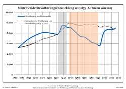 Development of Population since 1875 within the Current Boundaries (Blue Line: Population; Dotted Line: Comparison to Population Development of Brandenburg state; Grey Background: Time of Nazi rule; Red Background: Time of Communist rule)
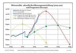 Recent Population Development and Projections (Population Development before Census 2011 (blue line); Recent Population Development according to the Census in Germany in 2011 (blue bordered line); Projection by the Brandenburg state for 2005-2030 (yellow line); Projection by the Brandenburg state for 2014-2030 (red line); Projection by the Bertelsmann Foundation for 2012-2030 (green line)
| Mittenwalde: Population development within the current boundaries (2017)[3] | ||||||||||||||||||||||||||||||||||||||||||||||||||||||||||||||||||||||||||||||||||||||||||||||||||||||||||||||||||||||||||||||||||||||
|---|---|---|---|---|---|---|---|---|---|---|---|---|---|---|---|---|---|---|---|---|---|---|---|---|---|---|---|---|---|---|---|---|---|---|---|---|---|---|---|---|---|---|---|---|---|---|---|---|---|---|---|---|---|---|---|---|---|---|---|---|---|---|---|---|---|---|---|---|---|---|---|---|---|---|---|---|---|---|---|---|---|---|---|---|---|---|---|---|---|---|---|---|---|---|---|---|---|---|---|---|---|---|---|---|---|---|---|---|---|---|---|---|---|---|---|---|---|---|---|---|---|---|---|---|---|---|---|---|---|---|---|---|---|---|
|
|
| ||||||||||||||||||||||||||||||||||||||||||||||||||||||||||||||||||||||||||||||||||||||||||||||||||||||||||||||||||||||||||||||||||||
References
- ↑ "Bevölkerung im Land Brandenburg nach amtsfreien Gemeinden, Ämtern und Gemeinden 31. Dezember 2017 (Fortgeschriebene amtliche Einwohnerzahlen auf Grundlage des Zensus 2011)". Amt für Statistik Berlin-Brandenburg (in German). 2018.
- ↑ https://news.yahoo.com/cash-strapped-berlin-stalked-540-old-debt-161927512.html
- ↑ Detailed data sources are to be found in the Wikimedia Commons.Population Projection Brandenburg at Wikimedia Commons
This article is issued from
Wikipedia.
The text is licensed under Creative Commons - Attribution - Sharealike.
Additional terms may apply for the media files.