Halbe
| Halbe | ||
|---|---|---|
| ||
 Halbe Location of Halbe within Dahme-Spreewald district 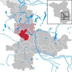 | ||
| Coordinates: 52°6′31″N 13°42′3″E / 52.10861°N 13.70083°ECoordinates: 52°6′31″N 13°42′3″E / 52.10861°N 13.70083°E | ||
| Country | Germany | |
| State | Brandenburg | |
| District | Dahme-Spreewald | |
| Municipal assoc. | Schenkenländchen | |
| Government | ||
| • Mayor | Ralf Kunze (Ind.) | |
| Area | ||
| • Total | 78.08 km2 (30.15 sq mi) | |
| Elevation | 35 m (115 ft) | |
| Population (2017-12-31)[1] | ||
| • Total | 2,402 | |
| • Density | 31/km2 (80/sq mi) | |
| Time zone | CET/CEST (UTC+1/+2) | |
| Postal codes | 15757 | |
| Dialling codes | 033765 | |
| Vehicle registration | LDS | |
| Website | gemeinde-halbe.de | |

Halbe (Lower Sorbian Łobje) is a municipality in the Dahme-Spreewald district of Brandenburg, Germany. It is situated near the capital city Berlin and the Spreewald. Four other villages are part of Halbe: Briesen/Brand with the Tropical Islands resorts of Dom, Teurow, Freidorf and Oderin.
Demography
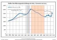
Development of population since 1875 within the current boundaries (Blue line: Population; Dotted line: Comparison to population development of Brandenburg state; Grey background: Time of Nazi rule; Red background: Time of communist rule)
| Halbe: Population development within the current boundaries (2017)[2] | ||||||||||||||||||||||||||||||||||||||||||||||||||||||||||||||||||||||||||||||||||||||||||||||||||||||||||||||||||||||||||||||||||||||
|---|---|---|---|---|---|---|---|---|---|---|---|---|---|---|---|---|---|---|---|---|---|---|---|---|---|---|---|---|---|---|---|---|---|---|---|---|---|---|---|---|---|---|---|---|---|---|---|---|---|---|---|---|---|---|---|---|---|---|---|---|---|---|---|---|---|---|---|---|---|---|---|---|---|---|---|---|---|---|---|---|---|---|---|---|---|---|---|---|---|---|---|---|---|---|---|---|---|---|---|---|---|---|---|---|---|---|---|---|---|---|---|---|---|---|---|---|---|---|---|---|---|---|---|---|---|---|---|---|---|---|---|---|---|---|
|
|
| ||||||||||||||||||||||||||||||||||||||||||||||||||||||||||||||||||||||||||||||||||||||||||||||||||||||||||||||||||||||||||||||||||||
See also
- The Battle of Halbe, which was fought in the last days of the Second World War.
- The Kaiserbahnhof Halbe, which was built for Kaiser Wilhelm I
References
- ↑ "Bevölkerung im Land Brandenburg nach amtsfreien Gemeinden, Ämtern und Gemeinden 31. Dezember 2017 (Fortgeschriebene amtliche Einwohnerzahlen auf Grundlage des Zensus 2011)". Amt für Statistik Berlin-Brandenburg (in German). 2018.
- ↑ Detailed data sources are to be found in the Wikimedia Commons.Population Projection Brandenburg at Wikimedia Commons
This article is issued from
Wikipedia.
The text is licensed under Creative Commons - Attribution - Sharealike.
Additional terms may apply for the media files.