Mihama, Fukui
| Mihama 美浜町 | |||
|---|---|---|---|
| Town | |||
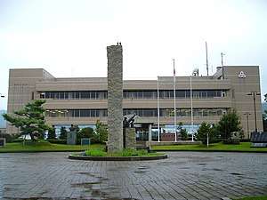 Mihama Town Hall | |||
| |||
 Location of Mihama in Fukui Prefecture | |||
 Mihama | |||
| Coordinates: 35°36′2.2″N 135°56′26.1″E / 35.600611°N 135.940583°ECoordinates: 35°36′2.2″N 135°56′26.1″E / 35.600611°N 135.940583°E | |||
| Country | Japan | ||
| Region | Chūbu (Hokuriku) | ||
| Prefecture | Fukui | ||
| District | Mikata | ||
| Area | |||
| • Total | 152.35 km2 (58.82 sq mi) | ||
| Population (August 2018) | |||
| • Total | 9,643 | ||
| • Density | 63/km2 (160/sq mi) | ||
| Time zone | UTC+9 (Japan Standard Time) | ||
| City symbols | |||
| -Tree | Pine | ||
| -Flower | Rhododendron | ||
| Phone number | 0770-32-1111 | ||
| Address | 25-25, Goichi, Mihama-cho, Mikata-gun, Fukui-ken 919-1192 | ||
| Website |
www | ||


Mihama (美浜町 Mihama-chō) is a town located in Fukui Prefecture, Japan. As of 1 May 2018, the city had an estimated population of 9,643 in 3175 households and the population density of 63 persons per km².[1] The total area of the town was 152.35 square kilometres (58.82 sq mi).
Geography
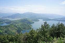
Mihama is located in southwestern Fukui Prefecture, bordered by Shiga Prefecture to the south and the heavily indented ria coast of Wakasa Bay of Sea of Japan to the north. Parts of the town are within the borders of the Wakasa Wan Quasi-National Park.
Neighbouring municipalities
- Fukui Prefecture
- Shiga Prefecture
Climate
Mihama has a Humid climate (Köppen Cfa) characterized by warm, wet summers and cold winters with heavy snowfall. The average annual temperature in Mihama is 14.7 °C. The average annual rainfall is 2200 mm with September as the wettest month. The temperatures are highest on average in August, at around 27.1 °C, and lowest in January, at around 3.6 °C.[2]
Demographics
Per Japanese census data,[3] the population of Mihama has been experiencing a steep population decline..
| Census Year | Population |
|---|---|
| 1970 | 13,157 |
| 1980 | 13,036 |
| 1990 | 13,222 |
| 2000 | 11,630 |
| 2010 | 10,563 |
History
Mihama is part of ancient Wakasa Province. During the Edo period, the area was part of the holdings of Obama Domain. Following the Meiji restoration, it was organised into part of Mikata District in Fukui Prefecture. With the establishment of the modern municipalities system on April 1, 1889, the villages of Kitasaigō, Minamisaigō, Mimi, and Santō were established. The four villages merged to form the town of Mihama on February 11, 1954.
On August 9, 2004, a non-radioactive steam leak killed five and burnt twelve others in the nearby Mihama Nuclear Power Plant; the high-pressure steam pipe lost 85% of its wall thickness and failed five days before its first inspection since 1976.[4]
Economy
The economy of Mihama, previously dependent on commercial fishing and agriculture, is now very heavily dependent on the nuclear power industry. The closure of the Mihama Nuclear Power Plant has since the 2011 Fukushima Nuclear Disaster has crippled the local economy.
Education
Mihama has three public elementary schools and one public middle school operated by the town government. The town does not have a high school.
Transportation
Railway
Highway
International relations
Local attractions
- Wakasa Wan Quasi-National Park
- Mikata Five Lakes, a Ramsar Site
- Lake Suigetsu
References
- ↑ "Official website of Mihama Town" (in Japanese). Japan: Mihama Town. Retrieved 25 May 2018.
- ↑ Mihama climate data
- ↑ Mihama population statistics
- ↑ http://www.corrosion-doctors.org/NuclearIndustry/nuclear-accident-1.htm
External links

- Official website (in Japanese)
- Tourist website of Mihama (in Japanese)
| Special city | ||
|---|---|---|
| Cities | ||
| Districts | ||