Ōi, Fukui
| Ōi おおい町 | |||
|---|---|---|---|
| Town | |||
 Ōi Town Hall | |||
| |||
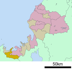 Location of Ōi in Fukui Prefecture | |||
 Ōi | |||
| Coordinates: 35°28′52.2″N 135°37′1,8″E / 35.481167°N 135.61667°ECoordinates: 35°28′52.2″N 135°37′1,8″E / 35.481167°N 135.61667°E | |||
| Country | Japan | ||
| Region | Chūbu (Hokuriku) | ||
| Prefecture | Fukui | ||
| District | Ōi | ||
| Area | |||
| • Total | 212.19 km2 (81.93 sq mi) | ||
| Population (April 2018) | |||
| • Total | 8,102 | ||
| • Density | 38/km2 (99/sq mi) | ||
| Time zone | UTC+9 (Japan Standard Time) | ||
| City symbols | |||
| -Tree | Myrica rubra | ||
| -Flower | Sakura | ||
| Phone number | 0770-77-1111 | ||
| Address | 71-7-1 Miyazaki, Takahama-cho, Ōi-gun, Fukui-ken 919-2292 | ||
| Website |
www | ||


Ōi (おおい町 Ōi-chō) is a town located in Fukui Prefecture, Japan. As of 1 June 2018, the town had an estimated population of 8,102 and a population density of 63 persons per km². The total area of the town was 212.19 square kilometres (81.93 sq mi). It is one of the few Hiragana towns in Japan.
Geography
Ōi is located in the far southwestern corner of Fukui Prefecture, bordered by Kyoto Prefecture to the south, Shiga Prefecture to the southeast and the heavily indented ria coast of Wakasa Bay of Sea of Japan to the north. Parts of the town are within the borders of the Wakasa Wan Quasi-National Park.
Neighbouring municipalities
- Fukui Prefecture
- Shiga Prefecture
- Kyoto Prefecture
Climate
Ōi has a Humid climate (Köppen Cfa) characterized by warm, wet summers and cold winters with heavy snowfall. The average annual temperature in Ōi is 14.9 °C. The average annual rainfall is 1949 mm with September as the wettest month.The temperatures are highest on average in August, at around 27.34nbsp;°C, and lowest in January, at around 3.9 °C.[1]
Demographics
Per Japanese census data,[2] the population of Ōi is in decline.
| Census Year | Population |
|---|---|
| 1970 | 9,291 |
| 1980 | 9,156 |
| 1990 | 10,598 |
| 2000 | 9,983 |
| 2010 | 8,580 |
History
Ōi is part of ancient Wakasa Province. During the Edo period, the area was part of the holdings of Obama Domain. Following the Meiji restoration, it was organised into part of Ōi District in Fukui Prefecture. With the establishment of the modern municipalities system on April 1, 1889, the villages of Saburi, Ōshima, and Hongō were established. These villages merged to form the town of Ōi on January 15, 1955. On March 3, 2006 the village of Natashō, from Onyū District, was merged into Ōi, which is since written with hiragana instead of kanji. Before the merger the town was written 大飯町.
Economy
The economy of Ōi, previously dependent on commercial fishing, forestry and agriculture is now very heavily dependent on the nuclear power industry. The partial closure of the Ōi Nuclear Power Plant has since the 2011 Fukushima Nuclear Disaster has adversely affected the local economy.
Education
Ōi has four public elementary schools and two public middle schools operated by the town government. The town does not have a high school.
Transportation
Railway
Highway
Local attractions
- Obama Domain Battery Sites, a National Historic Site
References
External links

- Official website (in Japanese)