Katsuyama, Fukui
| Katsuyama 勝山市 | |||
|---|---|---|---|
| City | |||
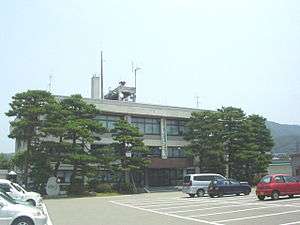 Katsuyama City Hall | |||
| |||
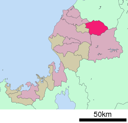 Location of Katsuyama in Fukui Prefecture | |||
 Katsuyama | |||
| Coordinates: 36°3′39.1″N 136°30′2.3″E / 36.060861°N 136.500639°ECoordinates: 36°3′39.1″N 136°30′2.3″E / 36.060861°N 136.500639°E | |||
| Country | Japan | ||
| Region | Chūbu (Hokuriku) | ||
| Prefecture | Fukui | ||
| Area | |||
| • Total | 253.88 km2 (98.02 sq mi) | ||
| Population (May 2018) | |||
| • Total | 23,527 | ||
| • Density | 93/km2 (240/sq mi) | ||
| Time zone | UTC+9 (Japan Standard Time) | ||
| City symbols | |||
| -Tree | Cryptomeria | ||
| -Flower | Satsuki Azalea | ||
| Phone number | 0779-88-1111 | ||
| Address | 1-1-1 Motomachi, Katsuyama-shi, Fukui-ken 911-8501 | ||
| Website |
www | ||


Katsuyama (勝山市 Katsuyama-shi) is a city located in Fukui Prefecture, Japan. As of 31 May 2018, the city has an estimated population of 23,527, with 7,973 households,[1] and a population density of 93 persons per km². The total area of the city was 253.88 square kilometres (98.02 sq mi). Katsuyama was the ninth-best ranking city in a ranking that compared health and sanitation in cities around the world published in April 2007.[2]
Geography
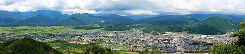
Katsuyama is located in the Katsuyama Basin of far northern Fukui Prefecture, bordered by Ishikawa Prefecture to the north, and surrounded by mountains on all sides. The Kuzuryū River flows through part of the city. Parts of the city are within the borders of Hakusan National Park.
Neighbouring municipalities
Climate
Katsuyama has a Humid climate (Köppen Cfa) characterized by warm, wet summers and cold winters with heavy snowfall. The average annual temperature in Katsuyama is 13.5 °C. The average annual rainfall is 2431 mm with September as the wettest month.The temperatures are highest on average in August, at around 26.3 °C, and lowest in January, at around 1.5 °C.[3]
Demographics
Per Japanese census data,[4] the population of Katsuyama has been declining over the past 40 years.
| Census Year | Population |
|---|---|
| 1970 | 32,691 |
| 1980 | 30,852 |
| 1990 | 29,805 |
| 2000 | 28,143 |
| 2010 | 25,466 |
History
Katsuyama is part of ancient Echizen Province. During the Edo period, the area was divided between the holdings of Echizen-Katsuyama Domain, Fukui Domain, Ōno Domain, and Gujō Domain. Following the Meiji restoration, it was organised into part of Ōno District in Fukui Prefecture. With the establishment of the modern municipalities system on April 1, 1889, the town of Katsuyama was established. It annexed the village of Inose on April 15, 1931, On September 1,1954, Katsuyama merged with the villages of Arado, Muraoka, Kitago, Kitadani, Shikadani, Osoha, Heisen-ji and Nomuki to form the city of Katsuyama.
Government
Katsuyama has a mayor-council form of government with a directly elected mayor and a unicameral city legislature of 16 members.
Economy
The economy of Katsuyama is primarily agricultural.
Education
Katsuyama has nine public elementary schools and thee middle schools operated by the city government, and one combined private elementary/middle school. The city has one public high school operated by the Fukui Prefectural Board of Education. The prefecture also operates one special education school.
Transportation
Railway
Highway
International relations

Local attractions
Notable people from Katsuyama
- Unshō Ishizuka, voice actor
References
- ↑ "Population of Katsuyama City" (in Japanese). Japan: Katsuyama City. Retrieved 8 July 2018.
- ↑ http://www.mercerhr.com/knowledgecenter/reportsummary.jhtml/dynamic/idContent/1128060#top50health
- ↑ Katsuyama climate data
- ↑ Katsuyama population statistics
External links


- Katsuyama City official website (in Japanese)
- Katsuyama City official website (in English)
| Special city | ||
|---|---|---|
| Cities | ||
| Districts | ||