Madikeri
| Madikeri Mercara | |
|---|---|
| town | |
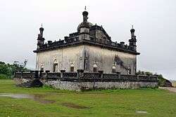 Gaddige Tomb | |
 Madikeri Location in Karnataka, India  Madikeri Madikeri (India) | |
| Coordinates: 12°25′15″N 75°44′23″E / 12.4209°N 75.7397°ECoordinates: 12°25′15″N 75°44′23″E / 12.4209°N 75.7397°E | |
| Country |
|
| State | Karnataka |
| District | Kodagu |
| Region | Coorg, Malnad |
| Elevation | 1,150 m (3,770 ft) |
| Population (2011) | |
| • Total | 33,381 |
| Languages | |
| • Administrative | Kannada |
| • Regional | Kodava, Arebhashe |
| Time zone | UTC+5:30 (IST) |
| PIN | 571 201 |
| Telephone code | 08272 |
| Vehicle registration | KA-12 |
| Website |
www |
Madikeri (previously called Mercara) is a hill station town in Madikeri taluk in Karnataka state, India. It is the headquarters of the district of Kodagu.
Etymology
Madikeri was formerly known as Muddu raja keri.[1] Muddurajakeri which means Mudduraja's town, was named after the prominent Haleri king Mudduraja who ruled Kodagu from 1633 to 1687.
History
The history of Madikeri is related to the history of Kodagu. From the 2nd to the 6th century AD, the northern part of Kodagu was ruled by Kadambas. The southern part of Kodagu was ruled by Gangas from the 4th to the 11th century. After defeating the Gangas in the 11th century, Cholas became the rulers of Kodagu. In the 12th century, the Cholas lost Kodagu to the Hoysalas. Kodagu fell to the Vijayanagar kings in the 14th century. After their fall, the local chieftains like Karnambahu (Palegars) started ruling their areas directly. They were defeated by Haleri Dynasty founder Veeraraju, (Nephew of Ikkeri Sadashiva Nayaka who were descendants of Talakadu Ganga Dynasty), and his father in-law Bomma Gowda, the Seeme Gowda of Haleri kings. In the year 1700AD Ikkeri Somashekara Nayaka gifted Puttur and Amara Sullia Magnes of Tulunadu to Haleri Kings. Descendants of Veeraraju who are known as "Haleri Dynasty" ruled Kodagu from 1600-1834 AD. Haleri king Mudduraja built the Fort in Madikeri and made it[2] as their capital. Mudduraja, the third Haleri king started leveling the land around Madikeri and built a fort in the year 1681. Madikeri Fort which was original built of mud and was replaced by Tipu Sultan. Kodagu became the part of British India after 1834 AD.[3]
Demographics
As of 2001 India census,[4] Madikeri had a population of 47,257. Males constitute 57.2% of the population and females 42.8%. Madikeri had an average literacy rate of 81%, higher than the national average of 57.2: male literacy was 83%, and female literacy 79%. 11% of the population was under 6 years of age. This town is situated at an elevation of over 6000 ft above sea level.
Geography and climate
Madikeri features a tropical highland climate as it has an elevation of 1150 metres (3838 feet). Madikeri is located at 12°25′N 75°44′E / 12.42°N 75.73°E.[5][6] Madikeri lies in the Western Ghats and is a popular hill station. The nearest cities are Mangaluru to the west, and Mysuru to the east.
The mean daily minimum temperature is lowest in January at about 11 °C. Maximum temperature in summer is around 24 °C to 27 °C.[7] With the onset of the south-west monsoon, the temperature decreases in June and the weather becomes chilly. The lowest temperature recorded is 4.5 °C.
| Climate data for Madikeri | |||||||||||||
|---|---|---|---|---|---|---|---|---|---|---|---|---|---|
| Month | Jan | Feb | Mar | Apr | May | Jun | Jul | Aug | Sep | Oct | Nov | Dec | Year |
| Record high °C (°F) | 29.9 (85.8) |
32.0 (89.6) |
33.1 (91.6) |
34.1 (93.4) |
35.2 (95.4) |
32.0 (89.6) |
30.8 (87.4) |
31.1 (88) |
31.5 (88.7) |
31.2 (88.2) |
30.4 (86.7) |
29.8 (85.6) |
35.2 (95.4) |
| Average high °C (°F) | 24.5 (76.1) |
27.2 (81) |
28.1 (82.6) |
28.4 (83.1) |
28.5 (83.3) |
24.8 (76.6) |
23.5 (74.3) |
21.8 (71.2) |
23.3 (73.9) |
25.0 (77) |
25.0 (77) |
25.2 (77.4) |
25.4 (77.8) |
| Average low °C (°F) | 13.3 (55.9) |
15.2 (59.4) |
16.6 (61.9) |
17.0 (62.6) |
17.5 (63.5) |
16.8 (62.2) |
16.5 (61.7) |
16.6 (61.9) |
16.7 (62.1) |
15.7 (60.3) |
14.7 (58.5) |
12.2 (54) |
15.7 (60.3) |
| Record low °C (°F) | 4.5 (40.1) |
4.8 (40.6) |
7.1 (44.8) |
12.2 (54) |
13.0 (55.4) |
13.0 (55.4) |
12.6 (54.7) |
12.3 (54.1) |
10.4 (50.7) |
8.8 (47.8) |
5.6 (42.1) |
5.0 (41) |
4.5 (40.1) |
| Average rainfall mm (inches) | 1.6 (0.063) |
1.1 (0.043) |
3.0 (0.118) |
33.0 (1.299) |
407.2 (16.031) |
1,010.1 (39.768) |
894.1 (35.201) |
741.5 (29.193) |
214.0 (8.425) |
177.6 (6.992) |
69.2 (2.724) |
3.5 (0.138) |
3,555.9 (139.995) |
Transportation
By road
Madikeri lies on the National Highway 275 that runs from Mangaluru to Bengaluru, via Mysuru within Karnataka. It is 120 km from Mysuru and 136 km from Mangaluru. From Bengaluru, the state capital of Karnataka, one can take the State Highway 17 (Bengaluru - Mysuru Highway) and take a deviation just after the town of Srirangapatna to join National Highway 275 towards Madikeri. It can be approached from Mangaluru via Puttur, Sullia passing through Sampaje Ghat. From Bengaluru, Madikeri is at a distance of 252 km. Nearby towns are Hassan (103 km), Sullia at a distance of 52 km in Karnataka state and Kasaragod, Kannur, Thalassery, Kanhangad and Uppala in Kerala state (each around 114 km away).
By rail
Madikeri does not have a railway station. The nearest railheads are Hassan, Kasaragod, Kanhangad, Kannur and Thalassery (each of which are almost equidistant at 115 km away). Mysuru at 120 km and Mangaluru at 136 km away are good alternatives to reach Madikeri from within Karnataka.
By air
Mangalore International Airport at Mangaluru (137 km) is the nearest International airport and offers flights from Mumbai, Bengaluru, New Delhi, Hyderabad, Chennai, Pune and Gulf countries.[8]
Places to see
.jpg)
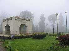
- Raja Seat: This is a small square viewing spot like a mantapa in brick and mortar of four pillars bridged by arches, enhanced by beautiful surroundings. This spot was a favourite place of recreation for the Rajas and hence was permanently associated with them. It is built on a high level ground with a commanding view of the cliffs and valleys to the west.
- Madikeri Fort: This fort was first built by Mudduraja in the last quarter of the 17th century. He also built a palace inside the fort. It was eventually rebuilt in granite by Tipu Sultan who named the site as Zafarabad. In 1790, Doddavira Rajendra took control of the fort. The British added to the fort in 1834. The palace was renovated by Linga Rajendra II between 1812 and 1814. In the north-east corner at the entrance are two life size masonry elephants, and a church is present in the south-east corner. There is a famous Lord Ganesha temple known as "Kote Ganapathi" just at the main entrance of the fort.
- St. Mark's Church: This disused church is located within the Mercara Fort, Coorg, India and was raised in 1859, by the officers and men of the East India Company and funded by the Government of Madras,[9] under the Church of England in India, Diocese of Madras.[10] The Church was closed after Indian independence, and taken over by the Government of Karnataka in 1971.[11] The building now houses the Madikeri Fort Museum, managed by the Karnataka State Archaeological Department.[12]
- Omkareshwara Temple: Located at the heart of the Town, Omkareshwara temple was built by king Linga Rajendra II in 1820. The temple has both Islamic and Gothic styles of architecture, built around a central pool. It is said Linga Rajendra killed an honest and pious Brahmin to fulfill his political ambitions. That Brahmin became a "Brahmarakshasa" and started troubling the king. In order to purify himself for the killing of a Brahmin, he was advised to construct a temple to Lord Shiva. He brought a Shivalinga from Kashi, and the temple was built and named "Omkareshwara".
- Abbey Falls is a waterfall situated 6 km from Madikeri town. Water from Kootu Holey dam near the town flows into the falls.
- Dubare Elephant Camp: At a distance of 29 km from Madikeri and 15 km from Kushalnagar, Dubare Elephant Camp is an elephant training center situated on the banks of the Kaveri. Dubare is a natural island formed by the river.
See also
References
- ↑ Coorg History Archived 2009-04-26 at the Wayback Machine.
- ↑ Puttur Anantharaja Gowda (2015). "IN PURSUIT OF OUR ROOTS".
- ↑ Jerry Dupont, The Common Law Abroad, Wm. S. Hein Publishing, 2001, ISBN 0-8377-3125-9, from p 592
- ↑ "Census of India 2001: Data from the 2001 Census, including cities, villages and towns (Provisional)". Census Commission of India. Archived from the original on 2004-06-16. Retrieved 2008-11-01.
- ↑ Madikeri, FallingRain.com
- ↑ "Maps, Weather, and Airports for Madikeri, India". www.fallingrain.com.
- ↑ Ground Water Information Booklet, Ministry of Water Resources, 2007. Retrieved 23 June 2011.
- ↑ "Airports Authority of India". Airports Authority of India. Archived from the original on 7 February 2015. Retrieved 31 January 2015.
- ↑ Penny, Frank (1922). The Church in Madras : being the History of the Ecclesiastical and Missionary Action of the East India Company in the Presidency of Madras From 1835 to 1861: Volume III. London: John Murray. p. 98. Retrieved 14 August 2015.
- ↑ "Chuches Vested in The Crown: Diocese of Madras". Lords Sitting of 31 May 1927. 67 (5): cc650-1. Retrieved 20 August 2015.
- ↑ "Museums in Karnataka". Government of Karnataka: Department of Archaeology, Museums and Heritage. 2015. Retrieved 21 August 2015.
- ↑ Madur (13 October 2014). "Madikeri Fort, Coorg". Karnataka. Retrieved 20 August 2015.
External links
| Wikimedia Commons has media related to Madikeri. |

- Madikeri.org: Portal on Madikeri and Coorg
- Madikeri: History and Architecture