Virajpet
| Virajpet Virajendrapete | |
|---|---|
| town | |
 Virajpet Location in Karnataka, India  Virajpet Virajpet (India) | |
| Coordinates: 12°12′N 75°48′E / 12.2°N 75.8°ECoordinates: 12°12′N 75°48′E / 12.2°N 75.8°E | |
| Country |
|
| State | Karnataka |
| District | Kodagu |
| Established | 1792 |
| Founded by | Dodda Virarajendra |
| Government | |
| • Body | Virajpet Town Panchayat |
| • President | E. C. Jeevan |
| • Vice-President | Tasma Akhtar |
| Area[1] | |
| • Total | 8.26 km2 (3.19 sq mi) |
| Elevation | 909 m (2,982 ft) |
| Population (2011) | |
| • Total | 17,246 |
| • Density | 2,100/km2 (5,400/sq mi) |
| Languages | |
| • Official | Kannada[2] |
| • Regional | Kodava, Konkani, Are Bhashe, Tulu, Marathi |
| Time zone | UTC+5:30 (IST) |
| PIN | 571 218 |
| Telephone code | 08274 |
| ISO 3166 code | IN-KA |
| Vehicle registration | KA-12 |
| Website |
www |
The town of Virajpet also spelled as Virajapete is the second town of the district of Kodagu, in Karnataka. It is the main town of the Virajpet taluka, south of the district, in the Kerala-Karnataka border. The name is an abbreviation of Virarajendrapete after the former ruler of Kodagu, Virarajendra, and this latter form is still sometimes used.
It is a small town of importance for the local coffee and spice crops. Nearby towns are Gonikoppal, Ammathi and Ponnampet. Virajpet is around 30 km away from Madikeri, the district headquarters and is about 250 km from Bangalore and 165 km from Mangalore. The only way to reach Virajpet is by road.
History
The name "Virajpet" is a shorter version of previous name "Virarajendrapet", named after the Haleri King Dodda Virarajendra who founded the town in 1792.[3] He founded the town to commemorate his meeting with General Robert Abercromby, his ally against Tipu Sultan, the ruler of the Kingdom of Mysore, in 1791. It was the headquarters of Yedenalknad taluk.[4]
The history of the destination is rich as it was ruled by various South Indian dynasties. The Gangas, the Kadambas, the Chalukyas, the Cholas, the Hoysalas, the Rastrakutas and the Vijaynagar Rayas also ruled the region. After the end of the ruling period, the region was segmented into three major towns namely, Madikeri, Virajpet and Somwarpet.
Tourism
Virajpet town is situated in the Kodagu District of Karnataka. It is considered as the main town of Virajpet Taluka. Located at a distance of 30 km from the district headquarters Madikeri, it shares its geographical borders with the major towns of the district – Ammathi, Gonikoppal and Ponnampet.
Some of the tourist attractions in and around Virajpet are the Ayyappa temple halfway up and the Shiva temple at the top of the Malethirike hill, a semispherical hill at Kakotuparambu which is about 8 km from Virajpet, St. Anne's church which is about 220 years old and has been built in Gothic architecture style. The tower of the church has two massive bells of the ancient times and are in use till date, the clock tower (pictured), Tadiandamol (the highest mountain in Kodagu) and the Igguthappa (local deity) temple, both in Kakkabe about 15 km from Virajpet.
The town is famous for its huge plantations of local coffee and spice crops. Virajpet is the largest honey producer in Asia. Ayyappa Temple and Shiva Temple on the top of Malethirike Hill, a semi-spherical hill at Kakotuparambu, are the prominent attractions that attract thousands of devotees.
Madikeri or Mercara Dasara is a prominent festival here, celebrated in the month of October. The celebration lasts for ten days along with cultural programmes depicting the victory of goddess of power over the asuras. A huge procession constituting singers, traditional dancers and music along with beautifully decorated ten tabloos is carried out. Virajpet can be visited in any season as the destination experiences pleasant climatic conditions throughout the year.
Demographics
Virajpet town has a population of 17,246 as per the 2011 Census of India. The number of males was 8,724 and females 8,522, thus a gender ration of 977 females to 1,000 males.[5] Virajpet's literacy rate is 93.12 per cent[5]—significantly higher than the national average of 74.04 per cent. The rate among males was 94.75 per cent and 91.46 per cent in females. 1,641 in number, 9.52 per cent of the population fall in the under-6 age group.[5]
Civic administration
| Virajpet Town officials[6] | |
|---|---|
| President | E. C. Jeevan |
| Vice-President | Tasma Akhtar |
The Virajpet Town Panchayat is the municipality in charge of the civic and infrastructural assets of the town. Virajpet has a town area of 8.26 km2 (3.19 sq mi).[1] The municipal council consists of 18 elected representatives, called councillors, one from each of the 18 wards (localities) of the town.[7] A councillor from the majority party is selected as a President.
For elections to the Lok Sabha, Virajpet falls under the Mysore constituency. Prior to revision of the constituencies by the Delimitation commission in 2008, the town came under Mangalore constituency.[8] For elections to the State Legislative Assembly, the town falls under the constituency that, apart from the town, includes the surrounding villages, and sends one member to the assembly.
Places of worship
- Malethirke temple
- Pathyarakkara temple
- St.Anne's Church
- Rahmaniya Mosque
Getting there
Virajpet is well connected with Mangalore, Mysore and Bangalore with road. Virajpet is also well connected by road with other places like Kannur, Thalassery, Iritty and Wayanad of neighbouring state Kerala.
The nearest railway stations are Thalassery and Kannur in Kerala, at a distance of 80 km each. Hassan and Mysore are other nearest Railway stations in Karnataka, at a distance of 138 km and 105 km respectively.
The nearest airports are Mysore Airport and Mangalore International Airport. Mysore Airport is at a distance of 115 km from Virajpet and Mangalore International Airport is at a distance of 172 km from Virajpet. Other major airports for Virajpet are Bangalore International Airport at a distance of 265 km and Kozhikkode International Airport at a distance of 176 km, which are much far from Virajpet. Kannur International Airport, under construction at Mattannur in Kerala is at a distance of 58 km from Virajpet.
See also
Gallery
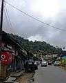 Jain Street
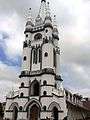 St.Anne's Church
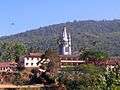 St.Anne's Church, Virajpet
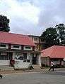 Post Office
 Temple near Post Office
 Temple on Rehmaniya Masjidh road
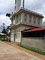 Church in Virajpet
References
- 1 2 "Virajpet Town Panchayat About Us". virajpettown.mrc.gov.in. Retrieved 23 February 2017.
- ↑ "THE KARNATAKA OFFICIAL LANGUAGE ACT, 1963" (PDF). Government of Karnataka. Retrieved 23 February 2017.
- ↑ "A melting pot of cultures". Deccan Herald. 19 December 2011. Archived from the original on 24 February 2017. Retrieved 24 February 2017.
- ↑ Rice, Lewis (1878). "History of Coorg". Mysore and Coorg, A Gazetteer compiled for the Government, Volume 3, Coorg. Bangalore: Mysore Government Press. p. 423.
- 1 2 3 "Virajpet Population Census 2011". census2011.co.in. Retrieved 23 February 2017.
- ↑ "Council Members". Virajpet Town Panchayat. Retrieved 23 February 2017.
- ↑ "Delimitation of Wards" (PDF). virajpettown.mrc.gov.in. 21 February 2017. Retrieved 23 February 2017.
- ↑ "Kodagu voters end up in Mysore". Business Standard. 22 April 2009. Archived from the original on 23 February 2017. Retrieved 23 February 2017.
External links
| Wikivoyage has a travel guide for Virajpet. |