Haymarket Square (Boston)
Haymarket Square is the historic name of a former town square in Boston, located between the North End, Government Center, the Bulfinch Triangle, and the West End. The square was a well-known feature of Boston from the mid-19th century to the mid-20th century, when the buildings around it were demolished to make way for the Central Artery[1] and Government Center. The Haymarket produce market continues to operate at a location near the historic site of the square.
History of the square
During the early years of European settlement in Boston, the future site of Haymarket Square was in a part of Boston Harbor called Mill Cove.[2]:73 The mouth of the cove was dammed in the 1640s, turning it into Mill Pond.[2]:74 In 1807, the town of Boston gave the Boston Mill Corporation permission to begin filling in Mill Pond.[3] A street plan for the filled land was proposed in 1808 by Charles Bulfinch.[2]:81 Filling of the pond to create the area known as the Bulfinch Triangle was completed in the early 1820s.[2]:98 The future location of Haymarket Square, where Merrimack, Canal, and Charleston Streets converged at the southern tip of the Bulfinch Triangle, appears on an 1826 map.[4]
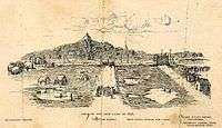
A drawing published in 1895[5] entitled "View of the New Land in 1828" shows Haymarket Square. Images from the early 1800s show hay being sold in the square.[6] The name Haymarket Square appears on an 1844 map.[7]
From its opening in 1845 to its demolition in 1897, the most prominent building on the square was the Boston and Maine Railroad depot.[8] In 1893, the depot was replaced by North Union Station, several blocks to the north on Causeway Street. The depot was demolished to make way for construction of the Canal Street Incline, the northern end of the Tremont Street Subway, the predecessor to the MBTA Green Line. The Haymarket Station on the subway line opened in 1898, with an entrance kiosk in the center of Haymarket Square. In 1902, the Haymarket Relief Station, a branch of Boston City Hospital, opened in a new building on the former site of the depot on the north side of the square.[9]
Most of the buildings around the square were demolished in the 1950s for the construction of the elevated Central Artery,[1] or in the 1960s for the construction of Government Center. Construction began in January 2017[10] on "Bulfinch Crossing,"[11] a 2.9 million square foot redevelopment on the site of the Government Center Garage.[12] The northeast corner of the garage is at the location of Haymarket Square.
The name "Haymarket" in Boston
The Haymarket Theatre operated in a building on the other side of Boston Common several decades before the creation of Haymarket Square.
Haymarket Station on the MBTA Orange and Green lines is located adjacent to the historic site of the square.
The Haymarket produce market is operated by the Haymarket Pushcart Association.[13]
Haymarket Square is the name of a hotel and market building[14] proposed for construction on Blackstone Street between Hanover Street and North Street, a block south of the historic location of Haymarket Square.
Image gallery
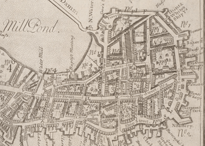 1743 map. Haymarket Square was built on land filled in the early 1800s. Its location was just north of the "Water Mill" shown on this map.
.jpg) Plan for the filling of the Bulfinch Triangle, 1807. Haymarket Square is at bottom center, at the southern end of Canal Street.
Plan for the filling of the Bulfinch Triangle, 1807. Haymarket Square is at bottom center, at the southern end of Canal Street.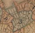 1826 map showing the newly filled land
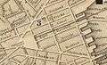 1844 map showing Haymarket Square
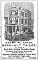 Advertisement for Henry Stone, tailor, 1850
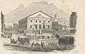 1852 engraving of Haymarket Square, with hay wagons. At rear is the Boston and Maine Railroad Depot, built in 1845.
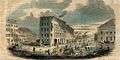 1853 view
.jpg) 1859 engraving by Winslow Homer, "Sleighing in Haymarket Square, Boston"
1859 engraving by Winslow Homer, "Sleighing in Haymarket Square, Boston" Advertisement for Sargent, Harlow & Co., carriages, sleighs and harnesses, 1861
 1865 photograph of Boston and Maine station
 1877 engraving of an aerial view of downtown Boston from the north; Haymarket Square is at center
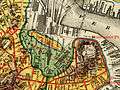 1880 map showing the location of Haymarket Square in relation to the original shoreline of Boston.
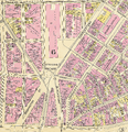 1895 Bromley Atlas
 1897 view to the south
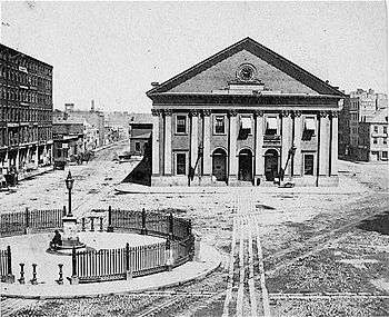
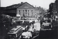 1897 view to the north, showing the Boston and Maine depot shortly before its demolition
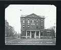 1905 photo of Boston City Hospital Haymarket Relief Station, built on the site of the train depot
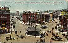 1909 postcard view. The kiosk in the square is an entrance to the Tremont Street Subway.
 1909 view from the north, showing the back of the Haymarket Relief Station. Subway tracks run on the Canal Street Incline, below the station.
 1955 drawing by Jack Frost: Connecting Links As Seen from Customs House Tower. Haymarket Square is in the center, with the new Central Artery at right.
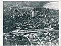 Late 1950s view of downtown looking west. Haymarket Square is the traffic circle at right center.
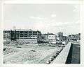 The John F. Kennedy Federal Building under construction in the 1960s. Haymarket Square and the Haymarket Relief Station are at right.
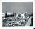 The Federal Building nears completion, and the Haymarket Relief Station is gone.
 Late 1960s view from the north, with the elevated Central Artery at left. What remains of Haymarket Square is the traffic circle at the center
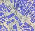 Approximate location of 2006 buildings overlaid on an 1881 map. The large building just to the west of Haymarket Square is the Government Center Garage.
 2007 view to the southwest of the Government Center Garage. The former location of Haymarket Square is in the foreground.
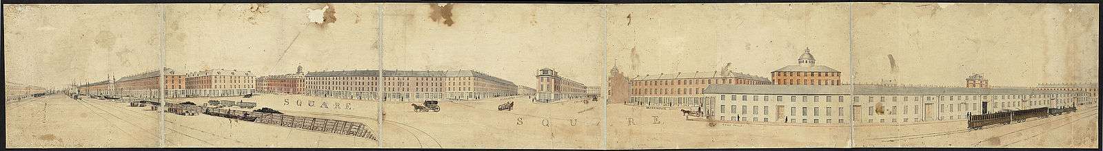
 Panoramic view looking north from the former location of Haymarket Square in 2016. The One Canal[15] apartment building is under construction at center.
References
- 1 2 Tsipis, Yanni (2000). Boston's Central Artery. Charleston, SC: Arcadia Publishing. pp. 38–42. ISBN 978-0-7385-0526-8.
- 1 2 3 4 5 Seasholes, Nancy S. (2003). Gaining Ground. Cambridge: MIT Press. ISBN 0-262-19494-5.
- ↑ Seasholes, Nancy (2006). Walking Tours of Boston's Made Land. Cambridge: The MIT Press. p. 33. ISBN 978-0-262-69339-4.
- ↑ Annin & Smith & J.V.N. Throop. "Plan of Boston comprising a part of Charlestown and Cambridge". Digital Commonwealth. Retrieved 23 January 2016.
- ↑ Johnson, James C. (1895). "The New Land". The Bostonian. II: 74. Retrieved 26 January 2016.
- ↑ "View of Haymarket Square, Boston, Mass". Digital Commonwealth. Retrieved 26 January 2016.
- ↑ Boynton. "Plan of the city of Boston". Digital Commonwealth. Boston Public Library. Retrieved 23 January 2016.
- ↑ Sammarco, Anthony Mitchell (2007). Boston's North End. Charleston, SC: Arcadia Publishing. p. 58. ISBN 978-0-7385-5503-4.
- ↑ "Relief Station Opens". Boston Evening Transcript. 20 February 1902. Retrieved 15 January 2016.
- ↑ Acitelli, Tom. "Bulfinch Crossing construction officially starts". Curbed Boston. Retrieved 31 January 2017.
- ↑ "Bulfinch Crossing". HYM Investment Group. Retrieved 22 June 2016.
- ↑ Boston Redevelopment Authority. "Government Center Garage Redevelopment". Retrieved 17 January 2016.
- ↑ "Haymarket". Haymarket Pushcart Association. Retrieved 19 January 2016.
- ↑ "Haymarket Square Parcel 9". Boston Redevelopment Authority. Retrieved 2 August 2015.
- ↑ "One Canal Apartment Homes". One Canal. Retrieved 18 January 2016.
Coordinates: 42°21′48.1″N 71°03′30.8″W / 42.363361°N 71.058556°W