Columbus Avenue (Boston)
Columbus Avenue (est.1860) in Boston, Massachusetts,[1] runs from Park Square to just south of Melnea Cass Boulevard, as well as from Tremont Street to Walnut Avenue and Seaver Street, where it continues as Seaver Street to Blue Hill Avenue and to Erie Street, where it ends.[2] It intersects the South End and Roxbury neighborhoods.
Buildings & tenants
|
|
Images
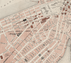 Map of Columbus Ave. and vicinity, 1883
 Boston and Providence R.R. Station, Park Square, late 19th century
 Bird's-eye view of Columbus Ave. and vicinity, 1902
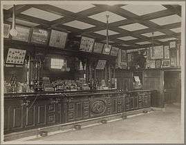 McGreevey's Third Base Saloon, no.940 Columbus Avenue, Roxbury Crossing, 1914 (Boston Public Library)
 2009
2009
References
- ↑ Boston Street Laying-Out Dept. A record of the streets, alleys, places, etc. in the city of Boston. Boston: City Printing Dept., 1910.
- ↑ City of Boston. Street book. Retrieved 2011-12-30
- ↑ School of Theology Library. "Methodist Churches in Boston Since 1792". New England Conference Commission on Archives and History. Boston University. Retrieved January 30, 2015.
- ↑ WGBH. Remembering the Savoy Cafe Archived 2012-05-12 at the Wayback Machine., 1976
- ↑ "Susan "Suze" Deitch". Northeastern Alumni. Northeastern University. Retrieved January 31, 2014.
External links
| Wikimedia Commons has media related to Columbus Avenue (Boston). |
- Bostonian Society has materials related to the street.
- Historic American Buildings Survey (Library of Congress).
- Police Station No. 10, 1170 Columbus Avenue, Boston. "This building is one of the first municipal buildings built in Roxbury after its annexation to Boston in 1868. It is also important as a work by Gridley J.F. Bryant, who with various partners designed a number of buildings in Boston and New England in the late 19th century."
- Edison-Spencer-Grafton Block, 254-264 Columbus Avenue, Boston
- New York Public Library. Item related to Columbus Ave., Boston
- Boston College.
- Hotel Statler, Columbus Avenue and Arlington Street photo, 1926
- Intersection of Stuart Street and Columbus Avenue, photo c. 1933
- City of Boston Archives. Photo of Columbus Avenue divisional strip project, June 2, 1948
- Columbus Avenue looking north east toward Concord Square, Columbus Ave. Anniversary of Battle of Bunker Hill, 1875. Photo by J.W. Black
- MIT. Photo
Route map:
This article is issued from
Wikipedia.
The text is licensed under Creative Commons - Attribution - Sharealike.
Additional terms may apply for the media files.