Mason, Michigan
| Mason, Michigan | |
|---|---|
| City, county seat | |
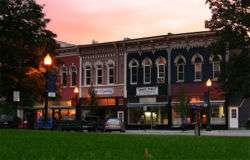 Downtown Mason, looking west from the Town Square. | |
| Nickname(s): Hometown, USA | |
 Location of Mason in Michigan. | |
| Coordinates: 42°34′45″N 84°26′37″W / 42.57917°N 84.44361°WCoordinates: 42°34′45″N 84°26′37″W / 42.57917°N 84.44361°W | |
| Country | United States |
| State | Michigan |
| County | Ingham |
| Settled | 1836 |
| Incorporated | 1865 |
| Government | |
| • Type | Council-Manager |
| • Body | Mason City Council |
| • Mayor | Russell W. Whipple |
| • Administrator | Deborah Stuart |
| Area[1] | |
| • Total | 5.13 sq mi (13.29 km2) |
| • Land | 5.10 sq mi (13.21 km2) |
| • Water | 0.03 sq mi (0.08 km2) |
| Elevation | 919 ft (280 m) |
| Population (2010)[2] | |
| • Total | 8,252 |
| • Estimate (2016)[3] | 8,395 |
| • Density | 1,600/sq mi (620/km2) |
| Time zone | UTC-5 (EST) |
| • Summer (DST) | UTC-4 (EDT) |
| ZIP code | 48854 |
| Area code(s) | 517 |
| FIPS code | 26-52180[4] |
| GNIS feature ID | 0631694[5] |
| Website | http://www.mason.mi.us |
Mason is a city in the U.S. state of Michigan. It is named after the state's first governor, Stevens T. Mason. As of the 2010 census, the city population was 8,252. It is the county seat of Ingham County.[6] Mason is the only city in the U.S. that serves as a county seat ahead of a state capital, with the capital of Lansing also in Ingham County. Despite Mason being the county seat, many county offices and courtrooms are located in Lansing.
History
In 1836 Charles Noble knew that Michigan would be seeking a central location for a new capital when it became a state. He purchased an area of forest, cleared 20 acres (81,000 m2), and founded Mason Center. The "Center" was soon dropped. In 1847, however, the state chose Lansing Township 12 miles (19 km) northward to be its capital due to its potential for water power. Noble managed to make Mason the county seat instead. Ingham County's first downtown courthouse was built in 1843, and was replaced in 1858, and then again in 1905.
In 1865, Mason was incorporated as a village; in 1875 the town became a city. In the 1800s, Mason was the center of Ingham County activity, even more than was Lansing, the state capital. In 1877, Lansing attempted to take the status of county seat for itself, but the two cities made an agreement that moved some county offices and courts to Lansing in exchange for Mason remaining the county seat. As a result, Michigan is the only state in the country with a capital city that is not also a county seat.
Up into the early 1900s, the local Ojibwa tribe had a visible presence in the town. In the 1900s, The Wyeth Corporation began producing baby formula in Mason, but that was discontinued in the 1990s. Today, it is home to the headquarters of Dart Container Corporation. Michigan Packaging Company, Lear Corporation, Gestamp Hardtech, and Ingham Intermediate School District also have facilities in the Mason area. Cattle can still be seen grazing within the city limits.[7]
The courthouse scenes of the 2011 film Real Steel were filmed at the Ingham County Courthouse in downtown Mason.
Geography
According to the United States Census Bureau, the city has a total area of 5.13 square miles (13.29 km2), of which 5.10 square miles (13.21 km2) is land and 0.03 square miles (0.08 km2) is water.[1] Sycamore Creek flows through the city.[8]
Mason sits upon the Mason Esker, which is one of the longest eskers in the western hemisphere.[9]
Transportation


- The Capital Area Transportation Authority (CATA) provides bus service from Lansing to Mason. Route 46 runs weekdays from downtown Lansing to the southside of Mason. The Mason Connector runs weekdays and Saturday from south Lansing to Mason.[10]
- Jewett Field is a general aviation airport located southeast of Mason. Scheduled passenger air carrier flights are provided by Capital Region International Airport located at the northwest corner of Ingham County.
Demographics
| Historical population | |||
|---|---|---|---|
| Census | Pop. | %± | |
| 1860 | 363 | — | |
| 1870 | 1,212 | 233.9% | |
| 1880 | 1,809 | 49.3% | |
| 1890 | 1,875 | 3.6% | |
| 1900 | 1,828 | −2.5% | |
| 1910 | 1,742 | −4.7% | |
| 1920 | 1,879 | 7.9% | |
| 1930 | 2,575 | 37.0% | |
| 1940 | 2,867 | 11.3% | |
| 1950 | 3,514 | 22.6% | |
| 1960 | 4,522 | 28.7% | |
| 1970 | 5,468 | 20.9% | |
| 1980 | 6,019 | 10.1% | |
| 1990 | 6,768 | 12.4% | |
| 2000 | 6,714 | −0.8% | |
| 2010 | 8,252 | 22.9% | |
| Est. 2016 | 8,395 | [3] | 1.7% |
| U.S. Decennial Census[11] | |||
2010 census
As of the census[2] of 2010, there were 8,252 people, 3,278 households, and 2,032 families residing in the city. The population density was 1,618.0 inhabitants per square mile (624.7/km2). There were 3,574 housing units at an average density of 700.8 per square mile (270.6/km2). The racial makeup of the city was 90.2% White, 5.9% African American, 0.4% Native American, 0.9% Asian, 0.8% from other races, and 1.7% from two or more races. Hispanic or Latino of any race were 3.7% of the population.
There were 3,278 households of which 30.4% had children under the age of 18 living with them, 44.8% were married couples living together, 13.3% had a female householder with no husband present, 3.9% had a male householder with no wife present, and 38.0% were non-families. 32.6% of all households were made up of individuals and 11.6% had someone living alone who was 65 years of age or older. The average household size was 2.29 and the average family size was 2.91.
The median age in the city was 37.8 years. 21.8% of residents were under the age of 18; 9.6% were between the ages of 18 and 24; 29.5% were from 25 to 44; 25.7% were from 45 to 64; and 13.5% were 65 years of age or older. The gender makeup of the city was 50.8% male and 49.2% female.
2000 census
As of the census[4] of 2000, there were 6,714 people, 2,806 households, and 1,826 families residing in the city. The population density was 1,466.6 per square mile (566.0/km²). There were 2,961 housing units at an average density of 646.8 per square mile (249.6/km²). The racial makeup of the city was 95.98% White, 0.64% African American, 0.46% Native American, 0.71% Asian, 0.74% from other races, and 1.46% from two or more races. Hispanic or Latino of any race were 2.73% of the population.

There were 2,806 households out of which 33.0% had children under the age of 18 living with them, 48.7% were married couples living together, 12.5% had a female householder with no husband present, and 34.9% were non-families. 30.4% of all households were made up of individuals and 11.0% had someone living alone who was 65 years of age or older. The average household size was 2.38 and the average family size was 2.96.
In the city, the population was spread out with 25.6% under the age of 18, 8.3% from 18 to 24, 30.7% from 25 to 44, 22.0% from 45 to 64, and 13.4% who were 65 years of age or older. The median age was 36 years. For every 100 females, there were 89.8 males. For every 100 females age 18 and over, there were 85.0 males.
The median income for a household in the city was $41,790, and the median income for a family was $53,519. Males had a median income of $41,081 versus $26,266 for females. The per capita income for the city was $20,866. About 1.3% of families and 4.1% of the population were below the poverty line, including 1.7% of those under age 18 and 7.6% of those age 65 or over
Government
Mason was first incorporated as a village in 1865, and was later incorporated as a municipality in 1875. The city provides a full range of services and facilities including public sanitary sewer, storm sewer, water, police and fire protection, street maintenance, parks and recreation facilities, and cemetery services. The city also owns and provides the land and building facilities for the Mason branch of the Capital Area District Library (CADL).
The City of Mason has a Council-Manager form of government, where a City Administrator manages the daily operation of city services and other functions, and a seven-member city council provides general oversight of city government by determining policy, enacting legislation, and approving the annual budget. Councilmembers are elected to four-year terms and the city council appoints one of its members to serve as mayor and another to serve as mayor pro tem.
| Name | Office | Term Expires |
|---|---|---|
| Russell W. Whipple | Mayor | 2020 |
| Marlon I. Brown | Mayor Pro Tem | 2018 |
| Mike Waltz | Councilmember | 2018 |
| Rita Vogel | Councilmember | 2020 |
| Jon Droscha | Councilmember | 2018 |
| Elaine Ferris | Councilmember | 2020 |
| Angela Madden | Councilmember | 2020 |
Economy
- Mason is home to Dart Container Corporation, the largest manufacturer of foam cups and containers in the world. Dart is known for being vertically integrated, and is one of the largest privately owned corporations in Michigan. Dart container also owns Solo.
Points of interest

- Mason Branch of the Capital Area District Library
- Mason Area Historical Museum
- Mason Skate Park
- Ingham County Fairgrounds
- Mason Antiques District "Cobblestone Village"
- Spartan Speedway
- Rayner Park
- Mason's Courthouse (was featured in Real Steel)
Celebrations and festivals
- Down Home Days, a Thursday through Sunday festival, centered on the third Saturday in September. A variety of community activities are planned for each day. Beginning in 1973, the outdoor Courthouse Show features arts, crafts, and other booths on Saturday around the courthouse, hosted by the Mason Area Chamber of Commerce.
- Spring Fling, a Thursday through Sunday festival, centered on the first Saturday in May. A variety of community activities are planned for each day. Beginning in 1983, the outdoor Courthouse Show features arts, crafts, and other booths on Saturday around the courthouse, hosted by the Mason Area Chamber of Commerce.
- Ingham County Fair the last week of July. This county fair began over 155 years ago.
- Mason Steam Engine & Thresher's Club Show, a steam engine show, starting the last Friday in July.
- Mason Aviation Day at Mason Jewett Airport in mid-August, hosted by EAA Chapter 55.
- Independence Day Celebration, on the 4th of July, daytime car show around the downtown Courthouse, evening parade hosted by the Mason Area Chamber of Commerce, and twilight fireworks at the Fairgrounds.
- Mason Holidays Celebration, the Friday after Thanksgiving, community tree lighting on Courthouse Square downtown light parade after dark, and more, hosted by the Mason Area Chamber of Commerce.
- Thursday Night Live summer outdoor concert series (weather permitting) on eight select Thursday evenings in the downtown Courthouse lawn, hosted by the Mason Area Chamber of Commerce.
- Annual Memorial Day Parade, Veterans Day Parade, and Homecoming Parade.
- Sun Dried Music Fest third weekend of August, hosted by the Mason Downtown Development Authority
- Friday night Meijer parking lot, every friday night all of the local hooligans get their trucks together and hang out in the local Meijer parking lot, it's a real hoot.
Notable people
- Malcolm X (then known as Malcolm Little) spent part of his childhood in the Ingham County Juvenile Home in Mason.[12][13]
- David Feintuch, author of the science fiction series the Seafort Saga, was a longtime resident of Mason.
- Mason is home to Kristin Haynie, a former point guard, who played in college basketball at Michigan State University. She played professionally in the Women's National Basketball Association and Europe. She is currently an assistant coach at Central Michigan University.
- John W. Longyear, a judge and politician, moved to Mason in 1844, where he taught school and studied law.
- Steve Clark, a Mason native, plays professional soccer for Columbus Crew SC in the MLS.
- Floyd Wilcox, born in Mason in 1886,[14] was the third president of Shimer College.
- Denny Stolz, a 1951 graduate of Mason High School, is a former college football coach. During his 23-year college coaching career, he was head coach for Alma College, Michigan State University, Bowling Green State University, and San Diego State University.
- Alan Curtis, born in Mason in 1934 and a graduate of Mason High School in 1951, was a harpsichordist, musicologist and conductor of baroque opera.
- Ion Cortright, a 1907 graduate of Mason High School, is a former college football and men's basketball coach. During his coaching career, he was head coach for the University of South Dakota, University of Cincinnati, and North Dakota Agricultural College (now North Dakota State University.
Notes
- 1 2 "US Gazetteer files 2010". United States Census Bureau. Archived from the original on 2012-01-24. Retrieved 2012-11-25.
- 1 2 "American FactFinder". United States Census Bureau. Retrieved 2012-11-25.
- 1 2 "Population and Housing Unit Estimates". Retrieved June 9, 2017.
- 1 2 "American FactFinder". United States Census Bureau. Retrieved 2008-01-31.
- ↑ U.S. Geological Survey Geographic Names Information System: Mason, Michigan
- ↑ "Find a County". National Association of Counties. Retrieved 2011-06-07.
- ↑ Schultz, Todd: Michigan History Magazine, issue January/February 2008, page 50.
- ↑ The National Map Archived 2012-04-05 at WebCite, accessed 2015-09-23
- ↑ Field Manual of Soil Engineering. Michigan. State Highway Dept. 1952. p. 8.
The longest esker in Michigan is called the Mason esker and it extends from the outskirts of Lansing to a point beyond Mason
- ↑ CATA Route 46 Mason, Limited, CATA.org, retrieved 2009-Nov-05
- ↑ "Census of Population and Housing". Census.gov. Retrieved June 4, 2015.
- ↑ Marable, Manning (2011). Malcolm X: A Life of Reinvention. New York: Viking. pp. 36–38. ISBN 978-0-670-02220-5.
- ↑ Perry, Bruce (1991). Malcolm: The Life of a Man Who Changed Black America. Barrytown, N.Y.: Station Hill. pp. 36–38, 42–43. ISBN 978-0-88268-103-0.
- ↑ "Students: 1913". The Institution Bulletin. 4. p. 274.
External links
| Wikimedia Commons has media related to Mason, Michigan. |
- Official Website of the City of Mason
- Official Website of the Mason Mason Area Chamber of Commerce
- Official Website of the Mason Public Schools
Municipalities and communities of Ingham County, Michigan, United States | ||
|---|---|---|
| Cities | 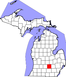 | |
| Villages | ||
| Charter townships | ||
| General law townships | ||
| CDPs | ||
| Other unincorporated communities | ||
| Footnotes | ‡This populated place also has portions in an adjacent county or counties | |