Marrucheti
| Marrucheti | |
|---|---|
| Frazione | |
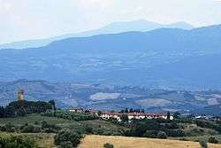 View of Marrucheti | |
 Marrucheti Location of Marrucheti in Italy | |
| Coordinates: 42°49′29″N 11°13′19″E / 42.82472°N 11.22194°ECoordinates: 42°49′29″N 11°13′19″E / 42.82472°N 11.22194°E | |
| Country |
|
| Region |
|
| Province | Grosseto (GR) |
| Comune | Campagnatico |
| Elevation | 115 m (377 ft) |
| Population (2011) | |
| • Total | 104 |
| Demonym(s) | Marruchetani |
| Time zone | UTC+1 (CET) |
| • Summer (DST) | UTC+2 (CEST) |
| Postal code | 58042 |
| Dialing code | (+39) 0564 |
Marrucheti is a village in Tuscany, central Italy, administratively a frazione of the comune of Campagnatico, province of Grosseto. At the time of the 2001 census its population amounted to 90.[1]
Marrucheti is about 14 km from Grosseto and 12 km from Campagnatico, and it is situated on the ancient road between Campagnatico and Istia d'Ombrone. The village was formerly known as Campino.
Main sights
- Church of Santa Maria Ausiliatrice, main parish church of the village, it was built in 1947.
- Chapel of Casetta Manini, a little church built in 1922.
- Castle of Stertignano (13th century), ancient castle situated a few kilometres west of the centre of Marrucheti.
References
Bibliography
- Aldo Mazzolai, Guida della Maremma. Percorsi tra arte e natura, Le Lettere, Florence, 1997
See also
This article is issued from
Wikipedia.
The text is licensed under Creative Commons - Attribution - Sharealike.
Additional terms may apply for the media files.