Marklesburg Historic District
|
Marklesburg Historic District | |
 The northwest side of Raystown Rd at the intersection with Chestnut and Aitch (also known as Clay, PA 3010, and Railroad St) | |
  | |
| Location | Jct. of PA 26 and PA 3010, Marklesburg, Pennsylvania |
|---|---|
| Coordinates | 40°22′57″N 78°10′22″W / 40.38250°N 78.17278°WCoordinates: 40°22′57″N 78°10′22″W / 40.38250°N 78.17278°W |
| Area | 35 acres (14 ha) |
| Architectural style | Gothic Revival |
| NRHP reference # | 96000084[1] |
| Added to NRHP | February 16, 1996 |
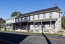
Marklesburg Historic District is a national historic district located at Marklesburg in Huntingdon County, Pennsylvania. The district includes 58 contributing buildings and 1 contributing site. The buildings primarily date between about 1845 and 1870 and include notable example of the Gothic Revival style. They are primarily of wood construction. It reflects the development of the community as a local service and commercial center for local agricultural and industrial customers. Notable buildings include the former Town Hall, former Indian Queen Hotel, former James Creek School House, former Methodist Episcopal Church, and St. Matthew's Lutheran Church. The Union Cemetery is the contributing site.[2]
It was listed on the National Register of Historic Places in 1996.[1]
References
- 1 2 National Park Service (2010-07-09). "National Register Information System". National Register of Historic Places. National Park Service.
- ↑ "National Historic Landmarks & National Register of Historic Places in Pennsylvania" (Searchable database). CRGIS: Cultural Resources Geographic Information System. Note: This includes Nancy L. Smith (July 1995). "National Register of Historic Places Inventory Nomination Form: Marklesburg Historic District" (PDF). Retrieved 2011-12-03.
| Wikimedia Commons has media related to Marklesburg Historic District. |
| Topics |   | |
|---|---|---|
| Lists by county |
| |
| Lists by city | ||
| Other lists | ||
| ||