Malmsmead
| Malmsmead | |
|---|---|
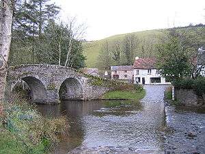 Malmsmead Bridge and the old ford | |
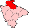
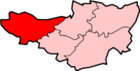
 Malmsmead Malmsmead shown within Devon | |
| OS grid reference | SS790478 |
| Civil parish | |
| District | |
| Shire county | |
| Region | |
| Country | England |
| Sovereign state | United Kingdom |
| Post town | LYNTON |
| Postcode district | EX35 6 |
| Police | Devon and Cornwall |
| Fire | Devon and Somerset |
| Ambulance | South Western |
| EU Parliament | South West England |
Malmsmead is a hamlet on the border between the English counties of Devon and Somerset. The nearest town is Lynton, which lies approximately 4.7 miles (7.6 km) west of the hamlet. The hamlet is situated in the Doone Valley within the Exmoor National Park.[1][2]
The border between the counties is along Badgworthy Water, which is crossed by the 17th-century Malmsmead Bridge and an even older adjacent ford. Badgworthy Water is also the boundary between the parishes of Oare (Somerset) and Brendon and Countisbury (Devon).
Malmsmead is both on the route of the Coleridge Way and Samaritans Way South West. Just to the north of the hamlet, Badgworthy Water merges with Oare Water to form the East Lyn River that flows into the sea at Lynmouth.
References
- ↑ "Malmsmead". Visit Exmoor. Retrieved 16 February 2016.
- ↑ "Doone Valley Campsite, Malmsmead". Retrieved 16 February 2016.
External links

This article is issued from
Wikipedia.
The text is licensed under Creative Commons - Attribution - Sharealike.
Additional terms may apply for the media files.