Malham
| Malham | |
|---|---|
 Malham Malham shown within North Yorkshire | |
| Population | 238 (2011 census)[1] |
| OS grid reference | SD900629 |
| District | |
| Shire county | |
| Region | |
| Country | England |
| Sovereign state | United Kingdom |
| Post town | SKIPTON |
| Postcode district | BD23 |
| Dialling code | 01729 |
| Police | North Yorkshire |
| Fire | North Yorkshire |
| Ambulance | Yorkshire |
| EU Parliament | Yorkshire and the Humber |
| UK Parliament | |
Malham is a village and civil parish in the Craven district of North Yorkshire, England. Before 20th century boundary changes, the village was part of the Settle Rural District, in the historic West Riding of Yorkshire. In the Domesday Book, the name is given as Malgun, meaning "settlement by the gravelly places".[2] In 2001 the parish had a population of approximately 150.[3] Malham parish increased in size geographically (to include Malham Moor) and so at the 2011 Census had a population of 238.[1]
Malham lies at the upper end of the valley of the River Aire, known above Airton as Malhamdale, in the Yorkshire Dales.[4] The surrounding countryside is well known for its limestone pavements and other examples of limestone scenery. Tourist attractions include Malham Tarn, Malham Cove, Gordale Scar, Janet's Foss and the Dry Valley. The village hosts an annual agricultural and horticultural show on the Saturday before the August Bank Holiday. Known as the Malham Show, it has competitions for everything from Lego models to fell running. Another major annual event is the Malham Safari, when the villagers and particularly the local school build sculptures around the village. This event attracts many tourists and stalls are put up on the green.
Tourism
Malham is a popular walkers' destination. The rise in tourism over Malham's history has led to some deterioration of the area's surrounding paths as tourists wander off the paths and cause pockets of erosion, a process often called "footpath erosion". The footpaths in the area are maintained by the Yorkshire Dales National Park Authority.
In the village there is a National Park Information Centre and a large car park. The Pennine Way long distance path passes through the village. Nearby natural landmarks include Malham Cove, Malham Tarn, Gordale Scar and Janet's Foss. The Malham Show Fell Race course runs over the nearby 301-metre (988 ft) Cawden.
In May 2006, it was reported that a covert listening device was discovered hidden in the local parish hall, leaving the villagers baffled. The electronic transmitter was found in a wall socket during a safety inspection at Malham village hall.[5]
Part of Harry Potter and the Deathly Hallows Part 1 was filmed around the Malham Cove limestone pavement.[6]
In the 1950s the village gave its name to a Ham class minesweeper, HMS Malham.
Governance
Malham has a joint parish council, Kirkby Malhamdale Parish Council, with the parishes of Malham Moor, Kirkby Malham and Hanlith.[7]
Climate
Malham has an Oceanic climate, but is generally colder and wetter than most settlements in Britain.[8] It has a relatively low altitude of around 200 metres, but is partly surrounded by fells. This exposed position means the temperature range is limited, due to little pooling of cold air. Extremes of temperature (since 1960) range from 28.2 °C (82.8 °F) during August 1990,[9] down to −13.5 °C (7.7 °F) during March 2001.[10]
| Climate data for Malham Tarn 381m asl, 1981-2010, extremes 1960- | |||||||||||||
|---|---|---|---|---|---|---|---|---|---|---|---|---|---|
| Month | Jan | Feb | Mar | Apr | May | Jun | Jul | Aug | Sep | Oct | Nov | Dec | Year |
| Record high °C (°F) | 12.5 (54.5) |
15.3 (59.5) |
18.9 (66) |
21.0 (69.8) |
23.7 (74.7) |
27.2 (81) |
28.0 (82.4) |
28.2 (82.8) |
24.4 (75.9) |
20.1 (68.2) |
15.2 (59.4) |
10.9 (51.6) |
28.2 (82.8) |
| Average high °C (°F) | 4.6 (40.3) |
4.7 (40.5) |
6.8 (44.2) |
9.5 (49.1) |
13.0 (55.4) |
15.3 (59.5) |
17.2 (63) |
16.8 (62.2) |
14.5 (58.1) |
10.8 (51.4) |
7.3 (45.1) |
5.0 (41) |
10.5 (50.9) |
| Average low °C (°F) | −0.3 (31.5) |
−0.5 (31.1) |
0.8 (33.4) |
2.5 (36.5) |
5.2 (41.4) |
8.1 (46.6) |
10.1 (50.2) |
9.9 (49.8) |
8.0 (46.4) |
5.2 (41.4) |
2.3 (36.1) |
0.1 (32.2) |
4.3 (39.7) |
| Record low °C (°F) | −11.5 (11.3) |
−13 (9) |
−13.5 (7.7) |
−7.5 (18.5) |
−4.2 (24.4) |
−1.1 (30) |
1.7 (35.1) |
2.1 (35.8) |
−1.0 (30.2) |
−4.9 (23.2) |
−9.2 (15.4) |
−12.6 (9.3) |
−13.5 (7.7) |
| Average rainfall mm (inches) | 167.1 (6.579) |
120.7 (4.752) |
132.1 (5.201) |
95.3 (3.752) |
86.1 (3.39) |
99.4 (3.913) |
105.0 (4.134) |
128.3 (5.051) |
125.3 (4.933) |
161.0 (6.339) |
157.8 (6.213) |
172.0 (6.772) |
1,550.1 (61.029) |
| Average rainy days | 18.0 | 14.4 | 16.0 | 13.7 | 12.8 | 13.6 | 13.5 | 15.3 | 14.0 | 16.9 | 18.2 | 17.4 | 183.8 |
| Mean monthly sunshine hours | 36.8 | 58.0 | 83.2 | 124.9 | 158.3 | 137.4 | 142.8 | 139.8 | 107.5 | 74.8 | 43.9 | 35.4 | 1,142.8 |
| Source #1: Met Office[11] | |||||||||||||
| Source #2: Royal Dutch Meteorological Institute/KNMI[12] | |||||||||||||
Picture gallery
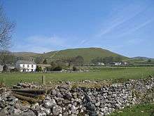 Malham is surrounded by stone-walled pastures
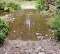 Ford
Ford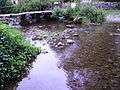 Small bridge
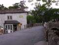 Sweet shop and Post Office
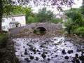
See also
References
- 1 2 UK Census (2011). "Local Area Report – Malham Parish (1170216772)". Nomis. Office for National Statistics. Retrieved 10 April 2018.
- ↑ Internet Surname Database
- ↑ "2001 census". Neighbourhood Statistics. Office for National Statistics.
- ↑ Yorkshire Dales National Park: Malhamdale Archived 17 May 2013 at the Wayback Machine.
- ↑ "Mystery surrounds parish hall bug". BBC News. 27 May 2006. Retrieved 8 November 2008.
- ↑ "Malham Cove Tourist Website". Malham Tourism. 12 June 2011. Retrieved 7 February 2011.
- ↑ "Kirkby Malhamdale Parish Council". malhamdale.com. Retrieved 4 February 2016.
- ↑ https://www.metoffice.gov.uk/public/weather/climate/gcw7y8w53
- ↑ "1990 temperature". KNMI.
- ↑ "2001 temperature". KNMI.
- ↑ "Malham Tarn 1981 - 2010 averages". UKMO. Retrieved 28 November 2017.
- ↑ "Malham extremes". KNMI. Retrieved 8 November 2011.
External links
| Wikimedia Commons has media related to Malham. |
| Wikivoyage has a travel guide for Malham. |